Aichi Prefecture
| Aichi Prefecture 愛知県 | |||
|---|---|---|---|
| Prefecture | |||
| Japanese transcription(s) | |||
| • Japanese | 愛知県 | ||
| • Rōmaji | Aichi-ken | ||
| |||
 | |||
| Coordinates: 35°10′48.68″N 136°54′48.63″E / 35.1801889°N 136.9135083°ECoordinates: 35°10′48.68″N 136°54′48.63″E / 35.1801889°N 136.9135083°E | |||
| Country | Japan | ||
| Region | Chūbu (Tōkai) | ||
| Island | Honshu | ||
| Capital | Nagoya | ||
| Government | |||
| • Governor | Hideaki Ōmura (since February 2011) | ||
| Area | |||
| • Total | 5,153.81 km2 (1,989.90 sq mi) | ||
| Area rank | 28th | ||
| Population (May 1, 2016) | |||
| • Total | 7,498,485 | ||
| • Rank | 4th | ||
| • Density | 1,454.94/km2 (3,768.3/sq mi) | ||
| ISO 3166 code | JP-23 | ||
| Districts | 7 | ||
| Municipalities | 54 | ||
| Flower | Kakitsubata (Iris laevigata) | ||
| Tree | Hananoki (Acer pycnanthum) | ||
| Bird | Scops-owl (Otus scops japonicus) | ||
| Fish | Kuruma prawn (Penaeus japonicus) | ||
| Website |
www | ||


Aichi Prefecture (愛知県 Aichi-ken) is a prefecture of Japan located in the Chūbu region.[1] The region of Aichi is also known as the Tōkai region. The capital is Nagoya. It is the focus of the Chūkyō Metropolitan Area.[2]
History
Originally, the region was divided into the two provinces of Owari and Mikawa.[3] After the Meiji Restoration, Owari and Mikawa were united into a single entity. In 1871, after the abolition of the han system, Owari, with the exception of the Chita Peninsula, was established as Nagoya Prefecture, while Mikawa combined with the Chita Peninsula and formed Nukata Prefecture. Nagoya Prefecture was renamed to Aichi Prefecture in April 1872, and was united with Nukata Prefecture on November 27 of the same year.
The government of Aichi Prefecture is located in the Aichi Prefectural Government Office in Nagoya, which is the old capital of Owari.
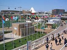
The Expo 2005 World Exposition was held in Seto and Nagakute.
Etymology
In the third volume of the Man'yōshū there is a poem by Takechi Kurohito that reads: "The cry of the crane, calling to Sakurada; it sounds like the tide, draining from Ayuchi flats, hearing the crane cry". Ayuchi is the original form of the name Aichi, and the Fujimae tidal flat is all that remains of the earlier Ayuchi-gata. It is now a protected area.[4][5]
For a time, an Aichi Station existed on the Kansai Line (at the time the Kansai Railway) between Nagoya and Hatta stations, but its role was overtaken by Sasashima-Live Station on the Aonami Line and Komeno Station on the Kintetsu Nagoya Line.
Geography


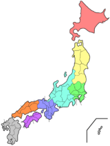
Located near the center of the Japanese main island of Honshu, Aichi Prefecture faces the Ise and Mikawa Bays to the south and borders Shizuoka Prefecture to the east, Nagano Prefecture to the northeast, Gifu Prefecture to the north, and Mie Prefecture to the west. It measures 106 km east to west and 94 km south to north and forms a major portion of the Nōbi Plain. With an area of 5,153.81 km2 it accounts for approximately 1.36% of the total surface area of Japan. The highest spot is Chausuyama at 1,415 m above sea level.
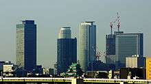
The western part of the prefecture is dominated by Nagoya, Japan's third largest city, and its suburbs, while the eastern part is less densely populated but still contains several major industrial centers. Due to its robust economy, for the period from October 2005 to October 2006, Aichi was the fastest growing prefecture in terms of population, beating Tokyo, at 7.4 per cent.
As of April 1, 2012, 17% of the total land area of the prefecture was designated as Natural Parks, namely the Aichi Kōgen, Hida-Kisogawa, Mikawa Wan, and Tenryū-Okumikawa Quasi-National Parks along with seven Prefectural Natural Parks.[6]
Cities
Thirty-eight cities are located in Aichi Prefecture.
Towns and villages

These are the towns and villages in each district:
Mergers
Economy
Companies headquartered in Aichi include the following.
| Aisin Seiki | Kariya |
| Brother Industries, Ltd. | Nagoya |
| Central Japan Railway Company | Nagoya |
| Denso Corporation | Kariya |
| Makita Corporation | Anjō |
| Matsuzakaya | Nagoya |
| Nagoya Railroad | Nagoya |
| Nippon Sharyo | Nagoya |
| Noritake | Nagoya |
| Sumitomo Riko | Komaki[7] |
| Toyota Motor Corporation | Toyota |
Companies such as Fuji Heavy Industries, Mitsubishi Motors, Pfizer, Sony, Suzuki, Bodycote, and Volkswagen Group also operate plants and/or branch offices in Aichi.
Demographics
As of 2001, Aichi Prefecture's population was 50.03% male and 49.97% female. 139,540 residents (nearly 2% of the population) are of foreign nationality.
Population by age (2001)
| Age | % population | % male | % female |
|---|---|---|---|
| 0 - 9 | 10.21 | 10.45 | 9.96 |
| 10 - 19 | 10.75 | 11.02 | 10.48 |
| 20 - 29 | 15.23 | 15.71 | 14.75 |
| 30 - 39 | 14.81 | 15.31 | 14.30 |
| 40 - 49 | 12.21 | 12.41 | 12.01 |
| 50 - 59 | 15.22 | 15.31 | 15.12 |
| 60 - 69 | 11.31 | 11.22 | 11.41 |
| 70 - 79 | 6.76 | 6.01 | 7.52 |
| Over 80 | 3.12 | 2.01 | 4.23 |
| Unknown | 0.38 | 0.54 | 0.23 |
Sports

The sports teams listed below are based in Aichi.
Football (soccer)
Baseball
Volleyball
- Toyoda Gosei Trefuerza (Nishikasugai District)
- Denso Airybees (Nishio)
- Toyota Auto Body Queenseis (Kariya)
Rugby
- Toyota Verblitz (Toyota)
- Nagoya Redbacks Australian Football Club
Tourism


Notable sites in Aichi include the Meiji Mura open-air architectural museum in Inuyama, which preserves historic buildings from Japan's Meiji and Taishō periods, including the reconstructed lobby of Frank Lloyd Wright's old Imperial Hotel (which originally stood in Tokyo from 1923 to 1967).
Other popular sites in Aichi include the tour of the Toyota car factory in the city by the same name, the monkey park in Inuyama, and the castles in Nagoya, Okazaki, Toyohashi, and Inuyama.
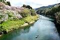
Because of Aichi's location along the Eastern seacoast, there are some scenic spots, but other than the Atsumi Peninsula surf beaches there are no significant beach destinations when compared to neighboring Shizuoka Prefecture. Most attractions are man-made destinations, dealing with the region's history or modern marvels.
-

Kiyosu Castle and Kiyosu Castle Park in Kiyosu
-

Meiji-mura
-

Tokoname pottery footpath
-
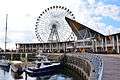
Laguna Ten Bosch
-

Site of Expo 2005
-

Field Mustard, Tahara
-
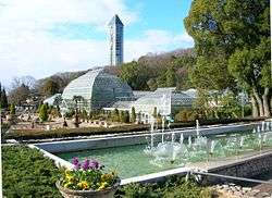
Higashiyama Zoo and Botanical Gardens
-
Sakurabuchi Park
-

Kisogawazutsumi


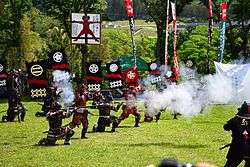
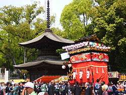
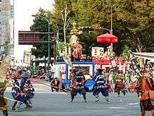
Festival and events
- Owari Tsushima Tenno Matsuri
- Inuyama Festival
- Kamezaki Shiohi Festival
- Chiryu Festival
- Nagoya Festival
- Tsutsui-chō/Dekimachi Tennō Festival
- Miya Festival
- Sea bream Festival
-

Owari Tsushima Tennōsai(eve)
-

Inuyama Festival
-

Kamezaki Shiohi Festival
-
Chiryu Festival
-
Nagoya Festival
-

Tsutsui-chō/Dekimachi Tennō Festival
-
Miya Festival
-

Sea bream Festival
Transport
Road
Expressways and toll roads
- Tomei Expressway
- Chuo Expressway
- Meishin Expressway
- East Meihan Expressway
- Tokai-Hokuriku Expressway
- Ise Bayside Expressway
- Chita Peninsula Road
- South Chita Road
- Chubu International Airport Connecting Road
- Chita across Road
- Nagoya Seto Road
- Nagoya Expressway
National highways
- Route 1
- Route 19 (Nagoya-Kasugai-Tajimi-Nagiso-Matsumoto-Nagano)
- Route 22 (Nagoya-Ichinomiya-Gifu)
- Route 23 (Ise-Matsuzaka-Suzuka-Yokkaichi-Nagoya-Toyoake-Chiryu-Gamagori-Toyohashi)
- Route 41 (Nagoya-Komaki-Inuyama-Gero-Takayama-Toyama)
- Route 42
- Route 151
- Route 153
- Route 154
- Route 155 (Tokoname-Chita-Kariya-Toyota-Seto-Kasugai-Komaki-Ichinomiya-Tsushima-Yatomi)
- Route 247
- Route 248
- Route 257 (Hamamatsu-Shinshiro-Toyota-Ena-Nakatsugawa-Gero-Takayama)
- Route 259
- Route 301
- Route 302
- Route 362
- Route 363
- Route 366
- Route 419
- Route 420
- Route 473 (Gamagori-Okazaki-Toyota-Shitara-Hamamatsu)
- Route 474
- Route 475
Rail

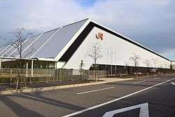
- JR Central
- Meitetsu
- Kintetsu
- Aonami Line
- Nagoya Municipal Subway
- Higashiyama Line
- Meijo Line
- Tsurumai Line (connecting to Meitetsu Toyota and Inuyama Line)
- Sakura-dori Line
- Meiko Line
- Kamiiida Line (connecting to Meitetsu Komaki Line)
- Toyohashi Railroad
- Aichi Loop Line
People movers and tramways
- Nagoya Guideway Bus
- Linimo
- Toyohashi Railroad
Airports
Ports
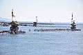
- Nagoya Port - International Container hub and ferry route to Sendai and Tomakomai, Hokkaido
- Mikawa Port - mainly automobile and car parts export and part of inport base
Notes
- ↑ Nussbaum, Louis-Frédéric. (2005). "Aichi-ken" Japan Encyclopedia, p. 11, p. 11, at Google Books; "Chūbu" Japan Encyclopedia, p. 126, p. 126, at Google Books.
- ↑ Nussbaum, "Nagoya" p. 685, p. 685, at Google Books.
- ↑ Nussbaum, "Provinces and prefectures" Japan Encyclopedia, p. 780, p. 780, at Google Books.
- ↑ "Summary of Aichi Prefecture". Aichi Prefecture. Retrieved 23 March 2011.
- ↑ Kato, Sadamichi (2000). "Rediscovering an Ancient Poem to Save a Tidal Flat". International Studies in Literature and Environment. Oxford University Press. 7 (2): 189–197. doi:10.1093/isle/7.2.189.
- ↑ "General overview of area figures for Natural Parks by prefecture" (PDF). Ministry of the Environment. Retrieved 8 July 2012.
- ↑ "Domestic production and sales bases." Sumitomo Riko. Retrieved on January 28, 2015.
References
- Nussbaum, Louis-Frédéric and Käthe Roth. (2005). Japan encyclopedia. Cambridge: Harvard University Press. ISBN 978-0-674-01753-5; OCLC 58053128
External links
| Wikimedia Commons has media related to Aichi prefecture. |
 Aichi travel guide from Wikivoyage
- Official website
- Aichi Now-Official Site for Tourism Aichi
- Aichi, HOME of the Samurai Spirit
- Oda, Nobunaga
- Tokugawa, Ieyasu
| Wards of Nagoya | ||
|---|---|---|
| Core cities | ||
| Special cities | ||
| Cities | ||
| Aichi District | ||
| Ama District | ||
| Chita District | ||
| Kitashitara District | ||
| Nishikasugai District | ||
| Niwa District | ||
| Nukata District | ||