Akita Prefecture
| Akita Prefecture 秋田県 | |||
|---|---|---|---|
| Prefecture | |||
| Japanese transcription(s) | |||
| • Japanese | 秋田県 | ||
| • Rōmaji | Akita-ken | ||
| |||
 | |||
| Country | Japan | ||
| Region | Tōhoku | ||
| Island | Honshu | ||
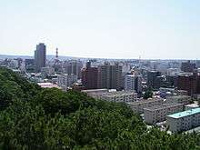
| Capital | Akita (city) | ||
| Government | |||
| • Governor | Norihisa Satake | ||
| Area | |||
| • Total | 11,612.22 km2 (4,483.50 sq mi) | ||
| Area rank | 6th | ||
| Population (2015-05-01[1]) | |||
| • Total | 1,026,983 | ||
| • Rank | 37th | ||
| • Density | 88/km2 (230/sq mi) | ||
| ISO 3166 code | JP-05 | ||
| Districts | 6 | ||
| Municipalities | 25 | ||
| Flower | Fuki (a kind of butterbur, Petasites japonicus) | ||
| Tree | Akita-sugi (Cryptomeria japonica) | ||
| Bird | Copper pheasant (Phasianus soemmerringii) | ||
| Website |
www | ||


Akita Prefecture (秋田県 Akita-ken) is a prefecture of Japan located in the Tōhoku region of northern Honshu, the main island of Japan.[2] The capital is the city of Akita.[3]
History
The area of Akita has been created from the ancient provinces of Dewa and Mutsu.[4]
Separated from the principal Japanese centres of commerce, politics, and population by several hundred kilometres and the Ōu and Dewa mountain ranges to the east, Akita remained largely isolated from Japanese society until after the year 600. Akita was a region of hunter-gatherers and principally nomadic tribes.
The first historical record of what is now Akita Prefecture dates to 658, when the Abe no Hirafu conquered the native Ezo tribes at what are now the cities of Akita and Noshiro. Hirafu, then governor of Koshi Province (the northwest part of Honshū bordering the Sea of Japan), established a fort on the Mogami River, and thus began the Japanese settlement of the region.
In 733, a new military settlement—later renamed Akita Castle—was built in modern-day Akita city at Takashimizu, and more permanent roads and structures were developed. The region was used as a base of operations for the Japanese empire as it drove the native Ezo people from northern Honshū.
It shifted hands several times. During the Tokugawa shogunate it was appropriated to the Satake clan, who ruled the region for 260 years, developing the agriculture and mining industries that are still predominant today. Throughout this period, it was classified as part of Dewa Province.[2] In 1871, during the Meiji Restoration, Dewa Province was reshaped and the old daimyō domains were abolished and administratively reconstructed, resulting in the modern-day borders of Akita.
The famous Heian period waka poet, Ono no Komachi, is said to have been born in Yuzawa City, Ogachi Town, located in the southeast of the prefecture.
Geography
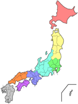
Located in the north of Honshu, Akita Prefecture faces the Sea of Japan in the west and is bordered by four other prefectures: Aomori in the north, Iwate in the east, Miyagi in the southeast, and Yamagata in the south.
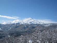
Akita Prefecture is rectangular in shape, roughly 181 km from north to south and 111 km from west to east. The Ōu Mountains mark the eastern border of the prefecture, and the higher Dewa Mountains run parallel through the center of the prefecture. Like much of northern Japan, the prefecture has cold winters, particularly away from the sea.
The Oga Peninsula is a prominent feature of the coastline.
Cities
Thirteen cities are located in Akita Prefecture:
Towns and villages
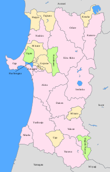
These are the towns and villages in each district:
Mergers
Economy
Like much of the Tōhoku Region, Akita's economy remains dominated by traditional industries, such as agriculture, fishing, and forestry. This has led many young people to migrate to Tokyo and other large cities. Akita Prefecture is where declines in population are most severe in Japan; it is one of four prefectures in Japan registering declines in population since 1945. It also has the lowest number of children as a percentage of the population, at 11.2%.[5] As of 2010, it has a population of just over 1 million people.[6]
Culture
Akita is famous for rice farming and its sake breweries.[7] It is well known for having the highest consumption of sake in Japan,[8] and thought to be the origin of the Akita breed of dog which carries the prefecture's name. The women of the region, referred to as Akita bijin (秋田美人 'beauties of Akita'), have also gained widespread renown for their white skin, rounded faces and high voices, all of which are considered highly desirable. Ono no Komachi is a famous example of an Akita bijin.
Food
Tourism

Near Lake Tazawa, there are a number of hot springs resorts (onsen). These are popular with tourists from all over Japan. In addition, its numerous seasonal festivals (matsuri) offer a glimpse of rural or traditional Japan. Some famous examples are the Akita Kantō, the Omagari Fireworks, Namahage Festival, and the Yokote Kamakura Festivals.
Kakunodate is a particularly charming old town, known as the little Kyoto, full of preserved samurai houses. The Aoyagi house is the former residence of Odano Naotake, the man who illustrated Japan's first modern guide to the human anatomy. The house is now a museum and gallery of medical illustrations and traditional crafts.
Starting in 2009, Akita began experiencing a huge surge in Korean tourism after the airing of the popular drama Iris, which featured several scenes shot in Akita, most notably at Lake Tazawa and Oga's GAO Aquarium.[10]
Famous festival and events
- Kariwano Big Tug Festival, Daisen (February[11])
- Amekko Festival, Odate (February[12])
- Kamakura Snow Statue Event, Yokote (February[13])
- Tsuchizaki Shinmei Festival, Akita (July)
- Akita Kanto Festival, Akita (August)
- Nishimonai Bon Dancing Festival, Ugo (August[14][15])
- Kemanai Bon Dancing Festival, Daisen (August[16])
- All Japan Firework Competition, Daisen (August[17])
- Kakunodate Festival, Senboku (September)
Transportation
Railroad
- JR East
- Akita Trans Inland Railway (Akita Nairiku Jyukan Railway)
- Yuri Plateau Railway (Yuri Kogen Railway)
Road
Expressway
- Akita Expressway
- Nihonkai-Tohoku Expressway
- Tohoku Expressway
- Yuzawa-Yokote Road
National Highway
- Route 7 (-Nikaho-Yurihonjō-Akita-Katagami-Ikawa-Gojōme-Hachirōgata-Mitane-Noshiro-Kitaakita-Ōdate-)
- Route 13 (-Yuzawa-Yokote-Misato-Daisen-Akita)
- Route 46 (-Senboku-Daisen-Akita)
- Route 101 (-Happō-Noshiro-Mitane-Oga-Katagami-Akita)
- Route 103 (-Kosaka-Kazuno-Ōdate)
- Route 104 (-Kazuno-Ōdate)
- Route 105 (Yurihonjō-Daisen-Senboku-Kitaakita)
- Route 107 (-Yokote-Yurihonjō)
- Route 108 (-Yuzawa-Yurihonjō)
- Route 282 (-Kazuno-Kosaka-)
- Route 341 (Kazuno-Senboku-Daisen-Akita-Yurihonjō)
- Route 342 (Yokote-Higashinaruse-)
- Route 397 (-Higashinaruse-Yokote)
- Route 398 (-Yuzawa-Ugo-Yurihonjō)
- Route 454 (-Kazuno-Towada, Aomori-Kosaka-)
Airport


Education
Universities in Akita Prefecture
- Akita International University
- Akita Prefectural University
- Akita University
- Akita University of Nursing and Welfare
- North Asia University
Media
Television
- Akita Asahi Broadcasting (AAB)
- Akita Broadcasting System (ABS)
- Akita Television (AKT)
Notes
- ↑ National Census 2015 Preliminary Results
- 1 2 Nussbaum, Louis-Frédéric. (2005). "Provinces and prefectures" in Japan Encyclopedia, p. 780, p. 780, at Google Books; "Tōhoku" in p. 970, p. 970, at Google Books.
- ↑ Nussbaum, "Akita" in p. 20, p. 20, at Google Books.
- ↑ Nussbaum, "Provinces and prefectures" in p. 780, p. 780, at Google Books
- ↑ "Number of children in Japan falls to record low for 29th year in row". The Japan Times. Kyodo News. May 4, 2010. Archived from the original on June 6, 2011. Retrieved May 26, 2011.
- ↑ 県人口108万5845人に減少 落ち込み幅最大、国勢調査速報 (in Japanese). December 28, 2010. Archived from the original on July 17, 2011. Retrieved December 28, 2010.
- ↑ Omura, Mika (November 6, 2009). "Weekend: Sake breweries go with the flow to survive". Retrieved December 29, 2009.
- ↑ The Appellation System for Sake in Akita Prefecture and Development Program for Akita Shun-ginjo, Kyuichi Saito, Journal of the Brewing Society of Japan; Vol. 87, No.11, 1992
- ↑ Akita Prefectural Guide, AKITA Prefecture
- ↑ 笠井 (Kasai), 哲也 (Tetsuya); 矢島大輔 (Yajima Daisuke) (April 21, 2010). 韓国人ファン、秋田に殺到 ドラマ「アイリス」効果. Asahi Shimbun (in Japanese). Japan. Archived from the original on April 23, 2010. Retrieved April 22, 2010.
- ↑ "刈和野の大綱引き" (pdf) (in Japanese). Daisen City. Retrieved November 26, 2015.
- ↑ "大館アメッコ市 - 秋田県大館市" (in Japanese). Odate City. Retrieved November 26, 2015.
- ↑ "(冬)横手のかまくら|横手市" (in Japanese). Yokote City. Retrieved November 26, 2015.
- ↑ "総合案内|羽後町" (in Japanese). Ugo Town. Retrieved November 26, 2015.
- ↑ "English|羽後町". Ugo Town. Retrieved November 26, 2015.
- ↑ "毛馬内の盆踊" (in Japanese). Kazuno City. Archived from the original on November 26, 2015. Retrieved November 26, 2015.
- ↑ "全国花火競技大会「大曲の花火」オフィシャルサイト|大曲商工会議所" (in Japanese). Omagari Enterpreneurs Group. Retrieved November 26, 2015.
References
- Nussbaum, Louis-Frédéric and Käthe Roth. (2005). Japan encyclopedia. Cambridge: Harvard University Press. ISBN 978-0-674-01753-5; OCLC 58053128
External links
| Wikivoyage has a travel guide for Akita (prefecture). |
![]() Media related to Akita prefecture at Wikimedia Commons
Media related to Akita prefecture at Wikimedia Commons
- Official Akita Prefecture website (Japanese)
- Official Akita Prefecture website
- Akita Sightseeing Guide
| Core city | ||
|---|---|---|
| Cities | ||
| Kazuno District | ||
| Kitaakita District | ||
| Minamiakita District | ||
| Ogachi District | ||
| Semboku District | ||
| Yamamoto District | ||
Coordinates: 39°43′7″N 140°6′9″E / 39.71861°N 140.10250°E