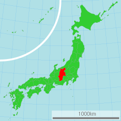
Nagano Prefecture
| Nagano Prefecture 長野県 | |||
|---|---|---|---|
| Prefecture | |||
| Japanese transcription(s) | |||
| • Japanese | 長野県 | ||
| • Rōmaji | Nagano-ken | ||
| |||
 | |||
| Country | Japan | ||
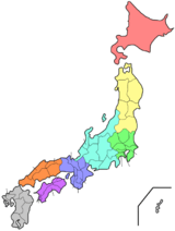
| Region | Chūbu (Kōshin'etsu) | ||
| Island | Honshu | ||
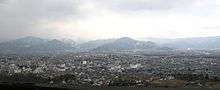
| Capital | Nagano | ||
| Government | |||
| • Governor | Shuichi Abe | ||
| Area | |||
| • Total | 13,585.22 km2 (5,245.28 sq mi) | ||
| Area rank | 4th | ||
| Population (February 1, 2011) | |||
| • Total | 2,148,425 | ||
| • Rank | 16th | ||
| • Density | 158.14/km2 (409.6/sq mi) | ||
| ISO 3166 code | JP-20 | ||
| Districts | 14 | ||
| Municipalities | 77 | ||
| Flower | Gentian (Gentiana scabra var. buergeri) | ||
| Tree | White birch (Betula platyphylla var. japonica) | ||
| Bird | Rock ptarmigan (Lagopus muta) | ||
| Website |
www | ||


Nagano Prefecture (長野県 Nagano-ken) is a landlocked prefecture of Japan located in the Chūbu region of the island of Honshu.[1] The capital is the city of Nagano.[2] Due to the abundance of mountain ranges in this area, the land available for inhabitance is relatively limited.
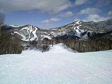
Nagano has impressive highland areas, including most of the Kita-Alps, Chūō-Alps, and Minami-Alps, which extend into the neighbouring prefectures. In addition to its natural scenic beauty and rich history, Nagano was host to the 1998 Winter Olympics, which gained the prefecture international recognition as a world-class winter sport destination, and a Shinkansen line to Tokyo.
History
See Shinano Province
Geography
Nagano is an inland prefecture and it borders more prefectures than any other in Japan. Nagano contains the point furthest from the sea in the whole of Japan - this point lies within the city of Saku. The province's mountains have made it relatively isolated, and many visitors come to Nagano for its mountain resorts and hot springs. Nine of the twelve highest mountains in Japan can be found in Nagano and one of its lakes, Lake Kizaki, is a beach resort popular for its water attractions and games.
As of April 1, 2012, 21% of the total land area of the prefecture was designated as Natural Parks, namely the Chichibu Tama Kai, Chūbu-Sangaku, Jōshin'etsu Kōgen, and Minami Alps National Parks; Myōgi-Arafune-Saku Kōgen, Tenryū-Okumikawa, and Yatsugatake-Chūshin Kōgen Quasi-National Parks; and Chūō Alps, Enrei Ōjō, Hijiriyama Kōgen, Mibugawa Suikei, Ontake, and Tenryū Koshibu Suikei Prefectural Natural Parks.[3]


Cities
Nineteen cities are located in Nagano Prefecture:
- Azumino
- Chikuma
- Chino
- Iida
- Iiyama
- Ina
- Komagane
- Komoro
- Matsumoto
- Nagano (capital)
- Nakano
- Okaya
- Ōmachi
- Saku
- Shiojiri
- Suwa
- Suzaka
- Tōmi
- Ueda
Towns and villages

These are the towns and villages in each district:
Mergers
Demographics
The lifespan in Nagano prefecture is the longest nationwide with the average life expectancy of 87.18 years for women and 80.88 years for men.[4]
Transportation
Railway
- East Japan Railway Company
- Nagano Shinkansen
- Shin'etsu Main Line
- Chūō Main Line (east line)
- Shinonoi Line
- Ōito Line (from Matsumoto to Minami-Otari)
- Koumi Line
- Central Japan Railway Company
- Chūō Main Line (west line)
- Iida Line
- West Japan Railway Company
- Ōito Line (from Minami-Otari to Itoigawa)
- Shinano Railway
- Nagano Electric Railway
- Nagano Line
- Yashiro Line
- Matsumoto Electric Railway
- Ueda Dentetsu
Road
Expressways
- Chuo Expressway
- Nagano Expressway
- Joshinetsu Expressway
- Sanen-nanshin Expressway
- Chubu-jukan Expressway
- Chubu-odan Expressway
National highways
- Route 18
- Route 19 (Nagano-Matsumoto-Shioriri-Nagiso-Nakatsugawa-Tajimi-Nagoya)
- Route 20 (Matsumoto-Suwa-Kofu-Otsuki-Hachioji-Nihonbashi of Tokyo)
- Route 117
- Route 141
- Route 142
- Route 143 (Matsumoto-Azumino-Ueda)
- Route 144
- Route 147 (Matsumoto-Omachi)
- Route 148 (Omachi-Itoigawa)
- Route 151 (Iida-Shinshiro-Toyohashi)
- Route 152
- Route 153 (Nagoya-Toyota-Iida-Shioriri)
- Route 158 (Fukui-Gujo-Takayama-Matsumoto)
- Route 254
- Route 256 (Gifu-Gujo-Gero-Nakatsugawa-Nagiso-Iida)
- Route 403
- Route 406 (Omachi-Hakuba-Nagano-Susaka-Tsumagoi-Takasaki)
- Route 418 (Ono-Seki-Ena-Iida)
Airports
Education
Universities
- Nagano University
- Nagano College of Nursing
- Shinshu University
- Matsumoto University
- Matsumoto Dental University
- Saku University
- Seisen Jogakuin College
- Suwa Tokyo University of Science
Tourism

- Lake Kizaki
- Lake Suwa
- Mount Kirigamine
- Suwa Taisha, one of the oldest shrines in Japan
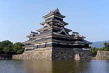
- Matsumoto Castle, one of Japan's national treasures.
- One of the world's highest geysers (about 40 to 50 meters) in Suwa.
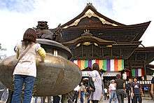
- Zenkō-ji temple in Nagano city
Sports
There are two local clubs J.League, AC Nagano Parceiro, Matsumoto Yamaga FC.
Prefectural symbols
- Siberian Silver Birch
- Gentian
- Ptarmigan
- Japanese Serow
- Shinano no Kuni (prefecture song)
Sister cities
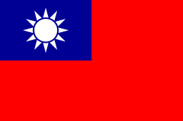 Changhua County, Taiwan (2008)
 Hebei, China
 Missouri, USA
Personalities
- Nagano's former governor, Yasuo Tanaka, is an independent who has made a reputation internationally for attacking Japan's status quo. Among other issues, he has refused national government money for construction projects that he deems unnecessary, such as dams, and has overhauled (locally) the press club system that is blamed for limiting government access to journalists who give favorable coverage. Tanaka was voted out from office on August 6, 2006 and was replaced by Jin Murai.
- Sasuke competitor Shinji Kobayashi, who works as a garbage man, is from Matsumoto in Nagano Prefecture.
- Tatsumi Yoda (aka Tom Yoda), former chairman of Avex, is from Chikuma-shi.
See also
Notes
- ↑ Nussbaum, Louis-Frédéric. (2005). "Nagano prefecture" in Japan Encyclopedia, p. 682, p. 682, at Google Books; "Chūbu" at p. 126, p. 126, at Google Books
- ↑ Nussbaum, "Nagano" at p. 682, p. 682, at Google Books
- ↑ "General overview of area figures for Natural Parks by prefecture" (PDF). Ministry of the Environment. Retrieved 25 April 2012.
- ↑ Nagano Prefecture has achieved the highest life expectancy in Japan, after long efforts of improving each one’s lifestyle (December 9, 2013). Foreign Press Center/Japan
References
- Nussbaum, Louis-Frédéric and Käthe Roth. (2005). Japan encyclopedia. Cambridge: Harvard University Press. ISBN 978-0-674-01753-5; OCLC 58053128
External links
| Wikivoyage has a travel guide for Nagano (prefecture). |
| Wikimedia Commons has media related to Nagano Prefecture. |
Coordinates: 36°15′N 138°6′E / 36.250°N 138.100°E