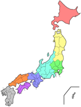
Tokushima Prefecture
| Tokushima Prefecture 徳島県 | |||
|---|---|---|---|
| Prefecture | |||
| Japanese transcription(s) | |||
| • Japanese | 徳島県 | ||
| • Rōmaji | Tokushima-ken | ||
| |||
|
| |||
| Country | Japan | ||
| Region | Shikoku | ||
| Island | Shikoku | ||
| Capital | Tokushima | ||
| Government | |||
| • Governor | Kamon Iizumi | ||
| Area | |||
| • Total | 4,144.95 km2 (1,600.37 sq mi) | ||
| Area rank | 36th | ||
| Population (May 1, 2016) | |||
| • Total | 751,969 | ||
| • Rank | 44th | ||
| • Density | 180/km2 (470/sq mi) | ||
| ISO 3166 code | JP-36 | ||
| Districts | 8 | ||
| Municipalities | 24 | ||
| Flower | Sudachi (Citrus sudachi) | ||
| Tree | Yamamomo (Myrica rubra) | ||
| Bird | White heron | ||
| Website | pref.tokushima.jp/english/ | ||
Tokushima Prefecture (徳島県 Tokushima-ken) is a prefecture of Japan located on Shikoku island.[1] The capital is the city of Tokushima.[2]
History
Until the Meiji Restoration, Tokushima Prefecture was known as Awa Province.[3]
Tokushima Prefecture and Myodo Prefecture
In ancient times, Tokushima City belonged to a region known as Myōdō-gun. In the first wave of government consolidation following the abolishment of the fiefdom system and construction of prefectures in 1871, it became known as Myodo Prefecture. At the time, it included the Awa region to the south and the Awaji Island regions as well. In 1873 it further incorporated the region currently occupied by Kagawa Prefecture in its borders.
In the second wave of government consolidation, on September 5, 1875, the Sanuki Region separated to form the modern day Kagawa Prefecture. On August 21, 1876, Awaji Island separated to join Hyogo Prefecture and the Awa region separated to form Kochi Prefecture.
On March 2, 1880, Myodo Prefecture fully separated from Kochi Prefecture to be inaugurated as Tokushima Prefecture.
Post-war
- 1945 August - End of World War II. The Washi no Mon gate to Tokushima Castle is destroyed by fire.
- 1946 December - The Nankai Earthquake occurs, causing vast damage throughout the prefecture.
- 1947 May - Naruto City is inaugurated.
- 1949 May - Tokushima University is created.
- 1951 June - Komatsushima City is inaugurated.
- 1953 November - The Prefectural Library is completed in Tokushima Park
- 1957 November - The Nagayasuguchi Dam is completed along the Naka River
- 1958 January - A ferry from Komatsushima to Wakayama sinks. All passengers are lost.
- 1958 May - Anan City is inaugurated.
- 1959 April - Shikoku Hoso begins TV broadcasts.
- 1960 May - A tsunami caused by a quake in Chile causes damage in the prefecture's south.
- 1961 April - The Short Term Women's College in Tokushima is opened, later reformed into Shikoku University.
- 1961 July - The Lesser Naruto Bridge is opened in the Lesser Naruto Straits.
- 1963 April - The Tokushima Municipal Culture Center is completed.
- 1963 July - A new thermal electric power plant is created in Anan.
- 1967 January - Construction of the Tokushima Airport terminal is completed.
- 1970 August - Construction of the Koboke Dam on the Yoshino River is terminated.
- 1972 January - Use of a railway connecting the towns of Itano and Kamiita is terminated.
- 1972 July - Construction of Route 11 over the Yoshino River Ohashi is completed.
- 1973 April - A railway is opened connecting the Mugi and Kaifu regions.
- 1974 October - Tokushima-born Takeo Miki is elected as Prime Minister of Japan.
- 1975 March - Construction of the Ikeda Dam over the Yoshino River is completed.
- 1976 July - A ceremony is held to celebrate the beginning of construction for the Onaruto Bridge.
- 1981 October - The National University Naruto Kyoiku Daigaku is opened.
- 1982 August - Ikeda Highschool takes first place in the 64th National Baseball Championships.
- 1985 March - Use of the Komatsushima trainline is stopped.
- 1985 - The Onaruto Bridge, connecting Tokushima and Hyogo Prefectures, is completed.
- 1989 May - The 40th National Planting Festival is held in the Kamiyama Shirin Park.
- 1990 January - Plans for a seaside park in Tokushima City are called off.
- 1990 November - Construction of the Bunka no Mori park area is completed, and the Tokushima Prefectural Library shifts grounds to here.
- 1991 June - Plans for a resort in the Kurozo Marsh in Ikeda-cho are called off.
- 1992 March - A railway is opened connecting the Kaifu and Kamoura regions.
- 1993 August - Route 55 is extended from Komatsushima City down to Anan City.
- 1993 September - The 48th National Citizen's Athletics Festival, Shikoku East Summer Festival is held conjunctively with Kagawa Prefecture.
- 1993 October - The East Shikoku Autumna Athletics Festival is held.
- 1993 October - Construction of Asty Tokushima is completed.
- 1994 March - The first highway in the prefecture is completed, running from Aizumi to Wakimachi.
- 1995 January - The Kobe Earthquake occurs, registering as a scale three quake in Tokushima.
- 1998 March - The Otsuka Museum of Fine Arts is opened.
- 1998 April - Tokushima and mainland Japan are connected with the completion of the Akaishi Kaikyo Bridge
- 1999 July - Construction of the Awa Odori Dance Hall is completed.
- 2000 January - A referrendum for building a sluice-gate dam over the Yoshino River is rejected by the citizens.
- 2000 July - Construction of a second thermal electric power generator is completed within the prefecture.
- 2000 October - Construction of the Hosokawauchi Dam over the Naka River is terminated.
- 2001 August - The 13th National Agricultural Youth Exchange takes place.
- 2002 March - Governor Toshi Endo is arrested under charges of bribery.
- 2002 October - The Prefectural Calligraphy Hall is opened.
- 2003 June - The Komatsushima factory for Toyobo is shut down.
- 2004 October - Yoshinogawa City is inaugurated.
- 2004 October - The 28th National Planting Festival is held in Kamiyama's Shirin Park.
- 2004 December - The soccer team Tokushima Vortis enters J2, making the first ever Shikoku J-league team.
- 2005 March - Mima City and the towns of Tsurugi and Naka are inaugurated.
- 2005 April - Anan City is inaugurated, and the South District Administration Bureau is created.
- 2005 April - The Shikoku Island League is created, and baseball team The Indigo Socks represents Tokushima.
- 2006 March - Miyoshi City and Higashi Miyoshi Town are inaugurated.
- 2006 March - The towns of Minami and Kaiyo are inaugurated.
- 2006 April - The West District Administration Bureau is created.
- 2006 May - The Tokushima Red Cross Hospital shifts location.
- 2007 May - The sports stadium Aguri Anan Stadium is opened.
- 2007 October - Tokushima becomes home for the 22nd National Culture Festival.
Geography
The Sanuki Mountains run along the northern border of the prefecture.
As of April 1, 2012, 9% of the total land area of the prefecture was designated as Natural Parks, namely the Setonaikai National Park; Muroto-Anan Kaigan and Tsurugisan Quasi-National Parks; and Chūbu Sankei, Dochū-Kōtsu, Hashikura, Higashi Sankei, Okumiyagawa-Uchidani, and Ōasayama Prefectural Natural Parks.[4]
Cities
Eight cities are located in Tokushima Prefecture:
|
Towns and villages
These are the towns and villages in each district:
Mergers
Economy and Industry
Tokushima depends on agriculture, forestry and fisheries. The percentage of agricultural workers and productivity is the second largest in Shikoku next to Kochi. Rice fields occupy the lower region of the Yoshino River and the small, narrow plains along the shore. Much of the remaining land is used for vegetables and flowers. The prefecture is the nation's largest supplier of cauliflower and lotus roots, and the fourth largest producer of carrots. Japanese indigo is only produced here.
Northern Tokushima's growth was accelerated by the completion of the Akashi Channel Bridge, which completes the road connection from Tokushima to Kobe. Industrial development continues around the Tokushima and Naruto districts. In particular, Itano District's Aizumi Town and Kitajima Town have experienced rapid growth, which has led to a proposed merger of the towns of Itano District into Itano City in the future.
Agriculture
Tokushima abounds in agricultural resources and is the site of large-scale production of many different types of vegetables. The plains north of the Yoshino River are particularly fertile and the produce here is often shipped to mainland Japan in the areas around Kobe, Osaka and Kyoto. Produce from Tokushima always claims top shares in markets in the Kansai region and particularly prominent are Naruto sweet potatoes, the citrus fruit "sudachi", lotus roots and strawberries.
The lack of goods heading to Tokyo has led to a relatively low national profile for local Tokushima brands. To combat this, the local Tokushima government now sends the "Fresh! Tokushima" moving display about the country with its mobile kitchen set to increase general awareness of the local food available in Tokushima Prefecture.
- Rice - Anan City
- Naruto Sweet Potatoes - Naruto City
- Corn - Ishii-cho, Yoshinogawa City East
- Sudachi - All across the prefecture, but mainly in Kamiyama-cho
- Bamboo Shoots - Anan City
- Spring Onions - Tokushima City
- Lettuce - Awa City and the north shore of the Yoshino River
- Lotus roots - Naruto City
- Carrots - All across the prefecture, but mainly in Aizumi-cho
- Cranshaw - All across the north shore of the Yoshino River, but mainly in Itano-cho
- Rakkyo - Naruto City
- Taranome - All across the West of the prefecture, but mainly in Yamashiro-cho, Miyoshi City
- Sencha - Yamashiro-cho, Naka-cho, and the former Aioi-cho
- Strawberries - All through the mountainous regions, but mainly in Sanagouchi-son
- Grapes - Awa City
- Egg plant - Naruto City
- Satsuma mandarins - All across the prefecture, but mainly in Katsuura-cho
- Yuzu - Naka-cho
- Yamamomo - Komatushima City
- Tsumamono - Kamikatsu-cho, Yamashiro-cho, Kamiyama-cho
- Daikon raddish - Naruto City
- Japanese apricot - Awa-shi, but mainly in Misato-son
Culture
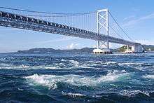
- Naruto whirlpools
- Awa Odori Kaikan Hall
- Mt. Bizan
- Jurobei Yashiki
- Tokushima Handicraft Village
- Iya Valley
- Oboke Koboke Gorge


Sports
The sports teams listed below are based in Tokushima.
Football (soccer)
Baseball
Prefectural symbols
Tokushima's prefectural symbol is a stylized combination of the hiragana for to and ku, the first two characters in the hiragana spelling of the prefecture's name.
Politics
Prefectural Governor (as elected by public vote)
- 1st - Goro Abe (阿部五郎 - April 16, 1947 - April 1, 1951
- 2nd - Kuniichi Abe (阿部邦一) - May 21, 1951 - March 30, 1955
- 3rd - Kikutaro Hara (原菊太郎) - April 25, 1955 - September 15, 1965
- 4th - Yasunobu Takeichi (武市恭信) - October 9, 1965 - October 4, 1981
- 5th - Shinzo Miki (三木申三) - October 5, 1981 - October 4, 1993
- 6th - Toshio Endo (圓藤寿穂) - October 5, 1993 - March 15, 2002
- 7th - Tadashi Oota (大田正) - April 30, 2002 - March 30, 2003
- 8th - Kamon Iizumi (飯泉嘉門) - May 19, 2003 – present
Prefectural Assembly
- All data is current to May 1, 2007.
| Party | Total |
|---|---|
| Total | 41 |
| Liberal Democratic Party / Shinsei Club | 11 |
| Liberal Democratic Party / Koyu Club | 9 |
| Meisei Club | 7 |
| Shinpu Democratic Club | 6 |
| Kaikaku Isshin Club | 3 |
| Japanese Communist Party | 3 |
| New Komeito Group | 2 |
See also
Notes
- ↑ Nussbaum, Louis-Frédéric. (2005). "Tokushima prefecture" in Japan Encyclopedia, p. 980, p. 980, at Google Books.
- ↑ Nussbaum, "Tokushima" at p. 980, p. 980, at Google Books.
- ↑ Nussbaum, "Awa no Kuni" at p. 62, p. 62, at Google Books; "Provinces and prefectures" at p. 780, p. 780, at Google Books
- ↑ "General overview of area figures for Natural Parks by prefecture" (PDF). Ministry of the Environment. Retrieved 26 June 2012.
References
- Nussbaum, Louis-Frédéric and Käthe Roth. (2005). Japan encyclopedia. Cambridge: Harvard University Press. ISBN 978-0-674-01753-5; OCLC 58053128
External links
| Wikimedia Commons has media related to Tokushima prefecture. |
 Tokushima Prefecture travel guide from Wikivoyage
- English language pages of the official Tokushima Prefecture website
- English Living Guide to Tokushima
- English Guide AWANAVI
| Cities | |
|---|---|
| Itano District | |
| Kaifu District | |
| Katsuura District | |
| Mima District | |
| Miyoshi District | |
| Myōdō District | |
| Myōzai District | |
| Naka District | |
Coordinates: 34°2′N 134°26′E / 34.033°N 134.433°E