Shaker Village Historic District (Shaker Heights, Ohio)
|
Shaker Village Historic District | |
|
Houses in the district | |
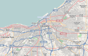   | |
| Location | Roughly bounded by Fairmount and Lomond Blvds., Green, Warrensville Center, Becket, and Coventry Rds., Shaker Heights, Ohio |
|---|---|
| Coordinates | 41°28′33″N 81°33′11″W / 41.47583°N 81.55306°WCoordinates: 41°28′33″N 81°33′11″W / 41.47583°N 81.55306°W |
| Area | 2,500 acres (1,000 ha) |
| Built | 1905 |
| Architect | Multiple |
| Architectural style | Late 19th And 20th Century Revivals |
| NRHP Reference # | [1] |
| Added to NRHP | May 31, 1984 |
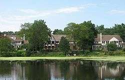
Shaker Village Historic District is a historic district between Fairmount and Lomond Boulevards, and Green, Warrensville Center, Becket, and Coventry Roads in Shaker Heights, Ohio. The district comprises roughly seventy percent of the city of Shaker Heights.[2]
The district was largely constructed between the late nineteenth century and early twentieth century. The area was once home to a large Shaker population. The district was added to the National Register of Historic Places in 1984.
See also
References
- ↑ National Park Service (2008-04-15). "National Register Information System". National Register of Historic Places. National Park Service.
- ↑ Mitchell, Sandy. "Shaker Heights, Ohio". Retrieved 2008-01-20.


This article is issued from Wikipedia - version of the 11/28/2016. The text is available under the Creative Commons Attribution/Share Alike but additional terms may apply for the media files.