Shaker Heights, Ohio
| Shaker Heights | ||
|---|---|---|
| City | ||
 | ||
| ||
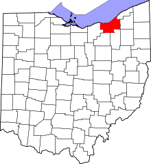
 Location in Cuyahoga County and the state of Ohio. | ||
.svg.png) Location of Ohio in the United States | ||
| Coordinates: 41°28′35″N 81°33′6″W / 41.47639°N 81.55167°W | ||
| Country | United States | |
| State | Ohio | |
| County | Cuyahoga | |
| Established | 1911 | |
| Incorporated | 1912 | |
| Government | ||
| • Mayor | Earl Leiken (D) | |
| Area[1] | ||
| • Total | 6.32 sq mi (16.37 km2) | |
| • Land | 6.28 sq mi (16.27 km2) | |
| • Water | 0.04 sq mi (0.10 km2) | |
| Elevation[2] | 1,050 ft (320 m) | |
| Population (2010)[3] | ||
| • Total | 28,448 | |
| • Estimate (2012[4]) | 28,039 | |
| • Density | 4,529.9/sq mi (1,749.0/km2) | |
| Time zone | Eastern (EST) (UTC-5) | |
| • Summer (DST) | EDT (UTC-4) | |
| ZIP codes | 44118, 44120, 44122 | |
| Area code(s) | 216 | |
| FIPS code | 39-71682[5] | |
| GNIS feature ID | 1065308[2] | |
| Website | www.shakeronline.com | |
Shaker Heights is a city in Cuyahoga County, Ohio, United States. As of the 2010 Census, the city population was 28,448. Shaker Heights is an inner-ring streetcar suburb of Cleveland, abutting the eastern edge of the city's limits. In July 1911, a petition by property owners was successful in detaching a long strip of land from the south of Cleveland Heights, to be named Shaker Village. In November 1911, the voters of Shaker Village formed Shaker Heights Village, which was incorporated in January 1912.
Shaker Heights was a planned community developed by the Van Sweringen brothers, railroad moguls who envisioned the community as a suburban retreat from the industrial inner city of Cleveland.
Geography
Topography
Shaker Heights is located at 41°28′35″N 81°33′6″W / 41.47639°N 81.55167°WCoordinates: 41°28′35″N 81°33′6″W / 41.47639°N 81.55167°W.[6] According to the United States Census Bureau, the city has a total area of 6.32 square miles (16.37 km2), of which 6.28 square miles (16.27 km2) is land and 0.04 square miles (0.10 km2) is water.[1]
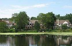
Shaker Heights is roughly 1,050 feet (320 m) above sea level,[2] and is located about 6 miles (10 km) inland from Lake Erie. Shaker Heights is drained by the Doan Brook watershed, and has several small artificial lakes: Horseshoe Lake, Green Lake, Lower Shaker Lake, and Marshall Lake.[7] Horseshoe Lake and Lower Shaker Lake had been dammed by the Shakers, while developers added Green Lake and Marshall Lake, the latter named after drugstore chain owner W. A. Marshall, at a later point.[8]
Cityscape

Shaker Heights is one of Greater Cleveland's older inner-ring or "first" suburbs, and borders Cleveland, Cleveland Heights, University Heights, Beachwood, Highland Hills, and Warrensville Heights.[9] Shaker Heights is a member of the Northeast Ohio First Suburbs Consortium.[10]
Neighborhoods
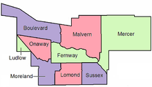
There are nine neighborhoods in Shaker Heights, all of which were named after the nine original elementary schools.[11] These neighborhoods are:
- Boulevard, located in northwest Shaker Heights, is near Cleveland's University Circle neighborhood, and borders Shaker Square. The Nature Center at Shaker Lakes is located in this neighborhood.
- Fernway is located in the middle of Shaker Heights, north of the RTA Rapid Transit Blue Line, and south of Shaker Heights Country Club.
- Lomond is located in the south-central part of the city.
- Ludlow is the smallest neighborhood and is located in the western portion of the city. Half of the neighborhood lies in Shaker Heights, while the other half is in Cleveland.[12]
- Malvern is mostly residential and is the location of Hathaway Brown School. The Hanna Perkins Center, a child development center, occupies the former Malvern school building.[13]
- Mercer, located in northeast Shaker Heights, is the largest neighborhood. The area is also home to Shaker Heights Middle School (previously Byron Junior High School), and the private schools University School and Laurel School. The eastern terminus of the RTA Rapid Transit Green Line, the Green Road Station, is located here, as well as the Bertram Woods branch of the Shaker Heights Public Library.
- Moreland is located in southwest Shaker Heights. The former Moreland school building now houses the Shaker Heights Public Library Main Branch.
- Onaway is home to Shaker Heights High School, and the former Woodbury Junior High School Building.
- Sussex is located in southeast part of the city and is the location of the Tower East office building and post office.
Shaker Square is in the city of Cleveland, though, in an agreement between the Shaker Heights and Cleveland schools made in September 1912, is in the Shaker Heights City School District.
Demographics
| Historical population | |||
|---|---|---|---|
| Census | Pop. | %± | |
| 1920 | 1,616 | — | |
| 1930 | 17,783 | 1,000.4% | |
| 1940 | 23,393 | 31.5% | |
| 1950 | 28,222 | 20.6% | |
| 1960 | 36,460 | 29.2% | |
| 1970 | 36,306 | −0.4% | |
| 1980 | 32,487 | −10.5% | |
| 1990 | 30,831 | −5.1% | |
| 2000 | 29,405 | −4.6% | |
| 2010 | 28,448 | −3.3% | |
| Est. 2015 | 27,646 | [14] | −2.8% |
As of the 2010 census,[3] there were 28,448 people, 11,840 households, and 7,716 families residing in the city. The population density was 4,529.9 inhabitants per square mile (1,749.0/km2). There were 13,318 housing units at an average density of 2,120.7 per square mile (818.8/km2). The racial makeup of the city was 55.0% White, 37.1% African American, 0.1% Native American, 4.6% Asian, 0.6% from other races, and 2.7% from two or more races. Hispanic or Latino of any race were 2.2% of the population.
There were 11,840 households of which 34.4% had children under the age of 18 living with them, 46.8% were married couples living together, 15.3% had a female householder with no husband present, 3.1% had a male householder with no wife present, and 34.8% were non-families. 31.1% of all households were made up of individuals and 12.6% had someone living alone who was 65 years of age or older. The average household size was 2.39 and the average family size was 3.03.
The median age in the city was 40.9 years. 26.7% of residents were under the age of 18; 5.8% were between the ages of 18 and 24; 23.1% were from 25 to 44; 29% were from 45 to 64; and 15.5% were 65 years of age or older. The gender makeup of the city was 45.2% male and 54.8% female.
The median income for a household in the city was $76,476, and the median income for a family was $105,660. The per capita income for the city was $47,360. About 5.3% of families and 8.6% of the population were below the poverty line, including 8.1% of those under age 18 and 6.5% of those age 65 or over.[16][17] The unemployment rate in the city is 5.4%, one of the lowest rates for individual cities included in data provided by the Ohio Department of Job and Family Services.[18]
About 93.5% of residents speak English natively at home, while 1.6% speak Spanish, 1.2% speak French, 0.7% speak Chinese, and 3.0% speak another language, including German, Russian and Arabic.[19]
Educationally, Shaker Heights is well above the national, state, and local averages for residents who have attained a bachelor's, master's, or above a master's degree. As of the 2010 Census, 64.5% of the city's population over the age of 25 had obtained a college degree compared to 28.6% of the same population in Cuyahoga County, 24.1% statewide, and 27.9% nationally.[20]
History
Shaker Heights was established in 1809, and incorporated as a village in 1912.[22] Shaker Heights is home to the oldest house in Cuyahoga County built in 1817, by Moses Warren.[23] The name "Shaker Heights" has origins in two local sources. The community was laid out on land formerly owned by the North Union Community of the United Society of Believers in Christ's Second Appearing, more commonly known as Shakers. "Heights" refers to the plateau east of Cleveland that rises sharply in elevation from 582 feet above sea level at the base of the Cedar Glen Parkway rising to 950 feet above sea level in nearby Cleveland Heights; Shaker Heights' elevation is 1050 feet above sea level.
Ralph Russell established the North Union Shaker Settlement in 1822 with just over 80 individuals. Between 1826 and 1854, the group dammed Doan Brook, which made Upper and Lower Lake, and established three grist and a sawmills.[24] The colony peaked around 1850 with about 300 settlers,[25] faded away and was closed in 1889.[25]
In 1905, the land was bought by brothers M.J. and O.P. Van Sweringen who envisioned the first garden styled suburb in Ohio for the site.[25] The brothers constructed homes, set aside land for churches and schools, and planted trees. Originally referred to as Shaker Village, the community was incorporated in 1912 and reached city status in the 1931.[26]
Shaker Heights is known for its stringent building codes and zoning laws, which have helped to maintain the community's housing stock and identity throughout the years.[27] Approximately seventy-five percent of the city of Shaker Heights is listed on the National Register of Historic Places as the Shaker Village Historic District.[28]
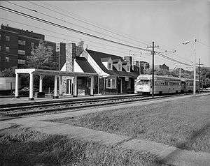
The Van Sweringens acquired the New York, Chicago and St. Louis Railroad (Nickel Plate Road) in order to secure the right of way needed to establish a rapid transit interurban streetcar system that would carry residents of Shaker Heights to and from downtown Cleveland. The resulting system was known as the Shaker Heights Rapid Transit. The Rapid Transit system was transferred into the Greater Cleveland Regional Transit Authority (RTA) in the 1970s, which combined the operation of all bus systems in the county with the operation of the Shaker and Cleveland Transit System west side rapid lines.[21] Shaker Heights and Greater Cleveland refer to the system and to the trains as "The Rapid Transit", "Rapid" or "Shaker Rapid". While originally envisioned to extend from downtown Cleveland fourteen miles to the community of Hunting Valley (then called Shaker Estates), the system expansion ended at Green Road in eastern Shaker Heights following the collapse of the Van Sweringen rail empire during the Great Depression.
Efforts toward integration began in the late 1950s with neighbors in the Ludlow Elementary School area working together to make integration successful.[12] As a result, Shaker Heights avoided many of the problems created from practices such as blockbusting and white flight. In 1986, the city began a Fund for the Future of Shaker Heights, offering loans for down payments for residents buying homes in segregated neighborhoods, creating multi-ethnic neighborhoods.[29] Today, the city maintains a housing assistance office that works with home buyers to achieve and maintain neighborhood integration.
Shaker Heights was a finalist for the All-America City Award in 1989.[30]
Government and politics
The Shaker Heights City Charter was adopted in 1931 and revised in 1974, 1986 and 1999. This charter provides for a mayor and seven members of a city council, elected on an at-large, non-partisan basis for four years. The current mayor of Shaker Heights is Earl Leiken.[31] The last mayoral and council elections being in 2007, the mayor and four council members selected in one election and three council members at the following, in a way to stagger terms.[32]
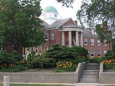
The Neo-Georgian city hall, designed by Charles Schneider, was built in 1930.[33] Over the years it has hosted 12 Keys to the city ceremonies starting in 1935 to Oris Paxton Van Sweringen and ending in 1993 to Dean Yoder.
Shaker Heights is entirely within the Eleventh Congressional District, a seat in the House of Representatives currently held by Marcia Fudge.[34]
Education

Publicly, Shaker Heights is served by the Shaker Heights City School District, a K-12 district with an enrollment of about 5,600 students in eight total schools. There are five lower elementary schools, Fernway, Mercer, Boulevard, Lomond and Onaway; an upper elementary school, Woodbury Elementary School; Shaker Heights Middle School; and Shaker Heights High School. The district estimates that roughly 90% of Shaker graduates attend college,[36] and has been recognized for its efforts to increase neighborhood integration.[37] In the 1950s, the public school system was rated in the top ten nationally. In recent years, however, the school district is no longer top rated. According to the 2007-2008 State of Ohio Report Card, Shaker scored 97.1 out of a possible 120. The district is listed as "Effective," the third tier on a 6 tier scale.[38] On the other hand, since 1995, 9-17% of seniors at Shaker Heights High School have been recipients of National Merit Scholarship awards,[39] and in 2008, the high school had twice as many National Merit Scholarship winners as any other public school in the state.[40] This can possibly be explained in a 2009 survey of the school, which said that Shaker Heights High School "is really two schools – one school with students in an outstanding Advanced Placement program and one school with students with academic needs."[41]
Private schools in the city include Laurel School, Hathaway Brown School, and the lower campus of University School. There is also a parochial school in Shaker, St. Dominic School.[42]
John Carroll University is partially located in Shaker Heights, with the university owning several residential and commercial properties in the city.[43] Additionally, Shaker Heights is in close proximity to University Circle, which is home to Case Western Reserve University, The Cleveland Institute of Art, and the Cleveland Institute of Music.
Media
Shaker Heights is the city of license for CBS affiliate WOIO, channel 19, which has its studios and offices in Cleveland.[44] Shaker Heights news appears in the Cleveland daily newspaper, The Plain Dealer, as well as The Shakerite, the Shaker Heights High School student newspaper. The Sun Press, a weekly, provides local coverage of Shaker Heights and neighboring Beachwood, Cleveland Heights, and University Heights.[45]
Shaker Heights is also referenced as the hometown of Ted Mosby, the main character of the TV Show How I Met Your Mother.[46] The city is also mentioned in The West Wing, in the episode, "The Long Goodbye"
See also
- List of people from Shaker Heights, Ohio
- Nature Center at Shaker Lakes
- The Battle of Shaker Heights (film set in Shaker Heights)
References
- 1 2 "US Gazetteer files 2010". United States Census Bureau. Retrieved 2013-01-06.
- 1 2 3 "US Board on Geographic Names". United States Geological Survey. 2007-10-25. Retrieved 2008-01-31.
- 1 2 "American FactFinder". United States Census Bureau. Retrieved 2013-01-06.
- ↑ "Population Estimates". United States Census Bureau. Retrieved 2013-06-17.
- ↑ "American FactFinder". United States Census Bureau. Retrieved 2008-01-31.
- ↑ "US Gazetteer files: 2010, 2000, and 1990". United States Census Bureau. 2011-02-12. Retrieved 2011-04-23.
- ↑ Behnke Associates, Inc. "The Doan Brook Watershed" (PDF). The Holden Parks Trust Distribution Committee. p. 1. Retrieved 2008-01-20.
- ↑ Marshall, Bruce T. (2006). Shaker Heights. Arcadia Publishing. p. 69. ISBN 0-7385-4050-1. Retrieved 4 June 2011.
- ↑ Housing Policy Research Program, Cleveland State University College of Urban Affairs. "Cities of the First Suburbs Consortium". Retrieved 2008-03-19.
- ↑ "Northeast Region". Northeast Ohio First Suburbs Consortium. Retrieved 2007-05-09.
- ↑ "Shaker Neighborhoods". Shaker Online. 2008. Retrieved 2008-02-05.
- 1 2 Maag, Christopher (2008-01-17). "A Suburb Looks Nervously at Its Urban Neighbor". New York Times. Retrieved 2008-06-12.
- ↑ "Directions to the Hanna Perkins Center for Child Development". 2007. Archived from the original on 2007-12-31. Retrieved 2008-02-05.
- ↑ "Annual Estimates of the Resident Population for Incorporated Places: April 1, 2010 to July 1, 2015". Retrieved July 2, 2016.
- ↑ "Census of Population and Housing". Census.gov. Retrieved June 4, 2015.
- ↑ American FactFinder - Results
- ↑ "Shaker Heights (city) QuickFacts from the US Census Bureau". Quickfacts.census.gov. Retrieved 2013-06-30.
- ↑ Legeza, Kasha; Michelle Simakis (27 January 2012). "Kent's Jobless Rate Drops to One of Lowest in Ohio". Kent Patch. Retrieved 29 January 2012.
- ↑ "MLA's Data Center Results for Shaker Heights, Ohio". Modern Language Association. 2000. Retrieved 21 June 2010.
- ↑ "Educational Attainment: United States, Ohio, Portage County, Ohio, and Kent city, Ohio". 2010 United States Census. United States Census Bureau. 2010. Retrieved 6 May 2013.
- 1 2 "About RTA: History of Public Transit in Greater Cleveland". Greater Cleveland Regional Transit Authority. 2007. Retrieved 2008-04-08.
- ↑ http://www.shakerhistoricalsociety.org/learn/early-settlers-and-warrensville-township/
- ↑ http://www.shakerhistoricalsociety.org/2011/12/%E2%80%9Cthe-famous-architects-of-shaker-heights%E2%80%9D/
- ↑ "North Union Shaker Site". National Park Service. Retrieved 2008-03-21.
- 1 2 3 "The North Union Shakers". Retrieved 2008-01-20.
- ↑ "Shaker Heights". Encyclopedia of Cleveland History. CWRU. 2003. Retrieved 4 June 2011.
- ↑ Segall, Grant (2008-12-02). "Demolition crew uncovers long-hidden Philco sign in Shaker Heights". The Plain Dealer. Retrieved 2008-12-13.
- ↑ Shaker Heights Landmark Commission. "Historical Development of Shaker Heights" (PDF). Retrieved 2014-06-07.
- ↑ Keating, W. Dennis (September 1988). "Suburban Cleveland's 20-Year Integration Struggle". American Planning Association. Archived from the original on May 9, 2008. Retrieved 2008-06-12.
- ↑ "Past Winners of the All-America City Award". Archived from the original on 2007-08-14. Retrieved 2007-10-08.
- ↑ Catanese, Marie (2008-11-07). "Leiken is new Shaker mayor; three return to council". Sun Press. Retrieved 2008-12-13.
- ↑ "Inside City Hall: City Council". 2007. Retrieved 2008-01-20.
- ↑ Forgac, Patricia (May 1981). "Architecture". The Physical Development of Shaker Heights. Ohio: Kent State University. p. 106.
- ↑ "Congressional District 11". National Atlas of the United States. United States Department of the Interior. Archived from the original (GIF) on 2008-04-08. Retrieved 2008-03-25.
- ↑ "CLEVNET Consortium". Cleveland Public Library. 2008. Retrieved 2008-06-09.
- ↑ "Fast Facts". Shaker Heights Schools. 2006. Retrieved 2008-01-25.
- ↑ Brand-Williams, Oralandar (2002-01-28). "Shaker Heights: City works at integration" (PDF). The Detroit News. Retrieved 2009-02-14.
- ↑ Heights City, Cuyahoga County "Shaker Heights City School District Report Card" Check
|url=value (help). State of Ohio Department of Education. 2008. Retrieved 2008-11-25. - ↑ "National Merit, National Achievement, and National Hispanic Scholarship Programs". Shaker Heights City School District. 2008-10-13. Retrieved 2008-12-13.
- ↑ Stephens, Scott (2008-05-12). "Shaker students score National Merit Scholarships". The Plain Dealer. Retrieved 2008-12-13.
- ↑ "Report of the Quality Assurance Review Team for Shaker Heights High School" (PDF). AdvancED Worldwide. 2009. p. 9. Retrieved 23 April 2010.
- ↑ "About Shaker: Education". Shaker Online. Retrieved 2008-01-21.
- ↑ Jewell, Thomas (2010-02-25). "John Carroll University and Shaker Heights reach off-campus housing accord". Sun News. Retrieved 16 July 2010.
- ↑ "FCC Information:WOIO". Federal Communications Commission. Retrieved 2008-01-20.
- ↑ "History of the Sun Newspapers". Case Western Reserve University. 1997-06-30. Retrieved 2008-01-20.
- ↑ "I'm Not That Guy", Season 3 Episode 6
Further reading
- Marshall, Bruce T. (2006). Shaker Heights. Arcadia Publishing. ISBN 0-7385-4050-1.
- Campen, Richard (1992). Distinguished Homes of Shaker Heights. Kent State University Press. ISBN 0-9601356-7-7.
External links
| Wikimedia Commons has media related to Shaker Heights, Ohio. |
| Wikivoyage has a travel guide for Shaker Heights. |
Municipalities and communities of Cuyahoga County, Ohio, United States | ||
|---|---|---|
| Cities |
|  |
| Villages | ||
| Townships | ||
| Footnotes | ‡This populated place also has portions in an adjacent county or counties | |
 |
Cleveland, Ohio | Cleveland Heights, Ohio | University Heights, Ohio | |
| Cleveland, Ohio | |
Beachwood, Ohio | ||
| ||||
| | ||||
| Cleveland, Ohio and Warrensville Heights, Ohio | Highland Hills, Ohio |