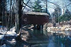
Schuylkill County Bridge No. 114
|
Schuylkill County Bridge No. 114 | |
 | |
  | |
| Location | East of Rock off Pennsylvania Route 895, Washington Township, Pennsylvania |
|---|---|
| Coordinates | 40°32′39″N 76°19′33″W / 40.54417°N 76.32583°WCoordinates: 40°32′39″N 76°19′33″W / 40.54417°N 76.32583°W |
| Area | 0.1 acres (0.040 ha) |
| Built | c. 1875 |
| Architectural style | Other, Burr arch |
| NRHP Reference # | 78002467[1] |
| Added to NRHP | January 3, 1978 |
Schuylkill County Bridge No. 114 (also known as Zimmerman's Covered Bridge) is a historic wooden covered bridge in Washington Township, Schuylkill County, Pennsylvania. It is a 50.6-foot-long (15.4 m), Burr Truss bridge, constructed about 1875. It crosses Little Swatara Creek west of the village of Rock.[2][3]
It was listed on the National Register of Historic Places in 1978.[1]
References
- 1 2 National Park Service (2010-07-09). "National Register Information System". National Register of Historic Places. National Park Service.
- ↑ "National Historic Landmarks & National Register of Historic Places in Pennsylvania" (Searchable database). CRGIS: Cultural Resources Geographic Information System. Note: This includes Helen Monices and Susan Zacher (n.d.). "National Register of Historic Places Inventory Nomination Form: Schuylkill County Bridge No. 114" (PDF). Retrieved 2012-05-29.
- ↑ "Zimmerman's, Schuylkill County". Covered Spans of Yesteryear - www.lostbridges.org. Retrieved July 14, 2013.
| Topics |   | |
|---|---|---|
| Lists by county |
| |
| Lists by city | ||
| Other lists | ||
| ||
This article is issued from Wikipedia - version of the 11/29/2016. The text is available under the Creative Commons Attribution/Share Alike but additional terms may apply for the media files.