Kalbar, Queensland
| Kalbar Queensland | |||||||||||||
|---|---|---|---|---|---|---|---|---|---|---|---|---|---|
 Kalbar Community Baptist Church | |||||||||||||
 Kalbar | |||||||||||||
| Coordinates | 27°56′S 152°37′E / 27.933°S 152.617°ECoordinates: 27°56′S 152°37′E / 27.933°S 152.617°E | ||||||||||||
| Population | 723 (2011 census)[1] | ||||||||||||
| Established | 1876 | ||||||||||||
| Postcode(s) | 4309 | ||||||||||||
| LGA(s) | Scenic Rim Regional Council | ||||||||||||
| State electorate(s) | Beaudesert | ||||||||||||
| Federal Division(s) | Wright | ||||||||||||
| |||||||||||||
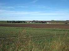
Kalbar is a small town and locality in the Scenic Rim, South East Queensland, Australia. It is located near the Cunningham Highway and directly north of Mount French in the Fassifern Valley. The town is part of the Scenic Rim Region local government area. At the 2011 census, Kalbar had a population of 723.[1]
History
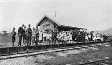

Settlement began at the location in 1876 and by 1890 a small town had developed.[2] The town was once known as Fassifern Scrub and then Engelsburg after the first settler of the town. The town has a very rich German history, reflected today in the many Anglo-German road and street names as well as the many local German settler descendant surnames. The name changed to Kalbar because of anti-German sentiment in 1916.[2] The Mount Edwards railway line reached the town in the same year.[2]
Engelsburg Post Office opened on 7 July 1897 (a receiving office had been open from 1878. known as Engels for five years) and was renamed Kalbar in 1916.[3]
During the 1899 referendum to decide if Australia should become a federation, Kalbar registered the highest No vote of any town in Queensland.[4] In 1920, the Kalbar School of Arts hall and half the businesses in town were destroyed by fire.[2]
From 1961 to 1990, Kalbar held a large annual celebration, the Fassifern Potato Festival. The event included a street parade with motorised floats culminating at the show grounds and continuation of festivities.[5][6] Some artifacts from the festival can be found at the Templin Historical Museum. Harvest Festivals organised by the local Salvation Army church extended back to the 1920s.[7][8][9] The annual agricultural show is held in June.
Heritage listings
Kalbar has a number of heritage-listed sites, including:
- 7 Ann Street: Wiss House[10]
- 1008B Boonah-Fassifern Road: Fassifern Homestead[11]
- 63 - 65 Edward Street: School of Arts and Memorial Hall [12]
- 99 George Street: Wiss Brothers Store[13]
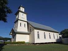
- Teviotville Road: St John’s Lutheran Church [12]
See also
References
- 1 2 Australian Bureau of Statistics (31 October 2012). "Kalbar (Urban Centre/Locality)". 2011 Census QuickStats. Retrieved 13 July 2014.
- 1 2 3 4 Environmental Protection Agency (Queensland) (2000). Heritage Trails of the Great South East. State of Queensland. pp. 36—37. ISBN 0-7345-1008-X.
- ↑ Premier Postal History. "Post Office List". Premier Postal Auctions. Retrieved 10 May 2014.
- ↑ "The Brisbane Wheel". Centenary of Federation. Australian Broadcasting Corporation. 12 March 2001. Retrieved 8 December 2009.
- ↑ Pfeffer, C. K (26 November 2007), Fassifern Potato Festival parade entering Kalbar Showgrounds, 1987, Scenic Rim Regional Council, retrieved 10 February 2015
- ↑ "Beautiful bikes". Scenic Rim. Scenic Rim Regional Council.
- ↑ "WEST MORETON NEWS.". Queensland Times (Ipswich) (Qld. : 1909 - 1954). Ipswich) (Qld.: National Library of Australia. 17 March 1923. p. 6 Edition: DAILY. Retrieved 10 February 2015.
- ↑ "KALBAR.". Queensland Times (Ipswich) (Qld. : 1909 - 1954). Ipswich) (Qld.: National Library of Australia. 15 March 1935. p. 12 Edition: DAILY. Retrieved 10 February 2015.
- ↑ "Farewell Socials At Kalbar.". Queensland Times (Ipswich) (Qld. : 1909 - 1954). Ipswich, Qld.: National Library of Australia. 1 March 1949. p. 4 Edition: DAILY. Retrieved 10 February 2015.
- ↑ "Wiss House (former) (entry 601137)". Queensland Heritage Register. Queensland Heritage Council. Retrieved 12 July 2013.
- ↑ "Fassifern Homestead (entry 602675)". Queensland Heritage Register. Queensland Heritage Council. Retrieved 12 July 2013.
- 1 2 "Local Heritage Register" (PDF). Scenic Rim Regional Council. Retrieved 9 February 2015.
- ↑ "Wiss Brothers Store & Dwelling (former) (entry 601200)". Queensland Heritage Register. Queensland Heritage Council. Retrieved 12 July 2013.
Further reading
- Krause, Herbert Albrecht; Fassifern Potato Festival Committee (1972), Out of the brigalows : history and reminiscences of the Kalbar district Queensland 1872-1972, Fassifern Potato Festival Committee
External links
| Wikimedia Commons has media related to Kalbar, Queensland. |