Rivière-au-Tonnerre, Quebec
| Rivière-au-Tonnerre | |
|---|---|
| Municipality | |
 | |
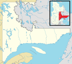 Rivière-au-Tonnerre Location in Côte-Nord region of Quebec | |
| Coordinates: 50°16′N 64°47′W / 50.267°N 64.783°WCoordinates: 50°16′N 64°47′W / 50.267°N 64.783°W[1] | |
| Country |
|
| Province |
|
| Region | Côte-Nord |
| RCM | Minganie |
| Settled | 1853 |
| Constituted | December 14, 1925 |
| Government[2] | |
| • Mayor | Jeannot Boudreau |
| • Federal riding | Manicouagan |
| • Prov. riding | Duplessis |
| Area[2][3] | |
| • Total | 632.50 km2 (244.21 sq mi) |
| • Land | 619.20 km2 (239.07 sq mi) |
| Elevation[4] | 15.20 m (49.87 ft) |
| Population (2011)[3] | |
| • Total | 307 |
| • Density | 0.5/km2 (1/sq mi) |
| • Pop 2006-2011 |
|
| • Dwellings | 335 |
| Time zone | EST (UTC−5) |
| • Summer (DST) | EDT (UTC−4) |
| Postal code(s) | G0G 2L0 |
| Area code(s) | 418 and 581 |
| Highways |
|
| Website |
www |
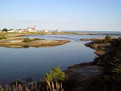
Rivière-au-Tonnerre is a municipality in the Côte-Nord region of the province of Quebec in Canada.
In addition to Riviere-au-Tonnerre itself, the communities within the municipality include Rivière-Pigou, Rivière-aux-Graines, and Sheldrake, all located along the Gulf of Saint Lawrence and accessible via Quebec Route 138.
The main and almost exclusive local economic activity is crab fishing. A factory which processes the crab meat sustains the bulk of the population.[1]
The eponymous Thunder River (French: Riviere au Tonnerre), which flows through the municipality, has a large series of waterfalls at 5 kilometers (3.1 mi) from its mouth in the Saint Lawrence. These falls with a total drop of about 50 meters (160 ft) have a roar that reminds one of the noise caused by thunder.[1]
History

The first permanent settlers arrived circa 1853 or 1854, and founded Sheldrake and Riviere-au-Tonnerre as fishing settlements. In 1875, more pioneers followed, originating notably from Paspébiac in the Gaspésie region. At the same time, the first chapel was built and the Parish of Saint-Hippolyte was formed. However it was commonly called Rivière-au-Tonnerre, like the settlement. In 1890, the post office opened under the English equivalent name of "Thunder River" (Frenchized in 1933). By 1908, there were 70 families engaged in agriculture. In 1925, the Municipality of Riviere-au-Tonnerre was formed.[1]
Demographics
Population
| Canada census – Rivière-au-Tonnerre, Quebec community profile | |||
|---|---|---|---|
| 2011 | 2006 | 2001 | |
| Population: | 307 (-21.3% from 2006) | 390 (-6.0% from 2001) | 415 (-12.8% from 1996) |
| Land area: | 619.20 km2 (239.07 sq mi) | 619.21 km2 (239.08 sq mi) | 619.26 km2 (239.10 sq mi) |
| Population density: | 0.5/km2 (1.3/sq mi) | 0.6/km2 (1.6/sq mi) | 0.7/km2 (1.8/sq mi) |
| Median age: | 55.2 (M: 56.2, F: 53.5) | 51.8 (M: 52.2, F: 51.1) | 44.7 (M: 45.4, F: 43.5) |
| Total private dwellings: | 335 | 294 | 351 |
| Median household income: | $.N/A | $50,950 | $40,938 |
| Notes: 2011 income data for this area has been suppressed for data quality or confidentiality reasons. – References: 2011[3] 2006[5] 2001[6] | |||
| Historical Census Data - Rivière-au-Tonnerre, Quebec[7] | ||||||||||||||||||||||||||
|---|---|---|---|---|---|---|---|---|---|---|---|---|---|---|---|---|---|---|---|---|---|---|---|---|---|---|
|
|
| ||||||||||||||||||||||||
Language
| Canada Census Mother Tongue - Rivière-au-Tonnerre, Quebec[7] | ||||||||||||||||||
|---|---|---|---|---|---|---|---|---|---|---|---|---|---|---|---|---|---|---|
| Census | Total | French |
English |
French & English |
Other | |||||||||||||
| Year | Responses | Count | Trend | Pop % | Count | Trend | Pop % | Count | Trend | Pop % | Count | Trend | Pop % | |||||
| 2011 |
305 |
305 | |
100.00% | 0 | |
0.00% | 0 | |
0.00% | 0 | |
0.00% | |||||
| 2006 |
390 |
390 | |
100.00% | 0 | |
0.00% | 0 | |
0.00% | 0 | |
0.00% | |||||
| 2001 |
415 |
415 | |
100.00% | 0 | |
0.00% | 0 | |
0.00% | 0 | |
0.00% | |||||
| 1996 |
470 |
470 | n/a | 100.00% | 0 | n/a | 0.00% | 0 | n/a | 0.00% | 0 | n/a | 0.00% | |||||
Climate
| Climate data for Rivière-au-Tonnerre | |||||||||||||
|---|---|---|---|---|---|---|---|---|---|---|---|---|---|
| Month | Jan | Feb | Mar | Apr | May | Jun | Jul | Aug | Sep | Oct | Nov | Dec | Year |
| Record high °C (°F) | 8.9 (48) |
7 (45) |
10.6 (51.1) |
18 (64) |
27 (81) |
27 (81) |
29 (84) |
29 (84) |
27.5 (81.5) |
19.4 (66.9) |
14 (57) |
9 (48) |
29 (84) |
| Average high °C (°F) | −8.6 (16.5) |
−6.5 (20.3) |
−1.1 (30) |
4.2 (39.6) |
10.6 (51.1) |
16.1 (61) |
19.1 (66.4) |
18.5 (65.3) |
13.9 (57) |
8 (46) |
1.8 (35.2) |
−5.1 (22.8) |
5.9 (42.6) |
| Daily mean °C (°F) | −14.2 (6.4) |
−12 (10) |
−6.3 (20.7) |
0.2 (32.4) |
5.8 (42.4) |
11.1 (52) |
14.4 (57.9) |
13.7 (56.7) |
9.4 (48.9) |
3.9 (39) |
−2.2 (28) |
−10.2 (13.6) |
1.1 (34) |
| Average low °C (°F) | −19.8 (−3.6) |
−17.5 (0.5) |
−11.4 (11.5) |
−3.8 (25.2) |
1 (34) |
6.2 (43.2) |
9.7 (49.5) |
8.9 (48) |
4.8 (40.6) |
−0.3 (31.5) |
−6.3 (20.7) |
−15.4 (4.3) |
−3.7 (25.3) |
| Record low °C (°F) | −40 (−40) |
−33.9 (−29) |
−32 (−26) |
−27 (−17) |
−12 (10) |
−3.3 (26.1) |
−1 (30) |
−1.1 (30) |
−5.6 (21.9) |
−15 (5) |
−25 (−13) |
−42 (−44) |
−42 (−44) |
| Average precipitation mm (inches) | 68.6 (2.701) |
51.5 (2.028) |
72.2 (2.843) |
86.6 (3.409) |
92.8 (3.654) |
101.3 (3.988) |
99 (3.9) |
97.8 (3.85) |
120.9 (4.76) |
118 (4.65) |
91.4 (3.598) |
80.4 (3.165) |
1,080.3 (42.531) |
| Average rainfall mm (inches) | 11.3 (0.445) |
10.1 (0.398) |
29 (1.14) |
71 (2.8) |
90.4 (3.559) |
101.3 (3.988) |
99 (3.9) |
97.8 (3.85) |
120.9 (4.76) |
116 (4.57) |
67 (2.64) |
15.1 (0.594) |
828.9 (32.634) |
| Average snowfall cm (inches) | 57.3 (22.56) |
41.4 (16.3) |
43.2 (17.01) |
15.5 (6.1) |
2.3 (0.91) |
0 (0) |
0 (0) |
0 (0) |
0 (0) |
1.9 (0.75) |
24.4 (9.61) |
65.4 (25.75) |
251.4 (98.98) |
| Source: Environment Canada[4] | |||||||||||||
See also
References
- 1 2 3 4 "Rivière-au-Tonnerre (Municipalité)" (in French). Commission de toponymie du Québec. Retrieved 2010-08-09.
- 1 2 "Rivière-au-Tonnerre". Répertoire des municipalités (in French). Ministère des Affaires municipales, des Régions et de l'Occupation du territoire. Retrieved 2012-05-07.
- 1 2 3 "Rivière-au-Tonnerre census profile". 2011 Census of Population. Statistics Canada. Retrieved 2012-05-07.
- 1 2 Environment Canada – Canadian Climate Normals 1971–2000, accessed 7 May 2012
- ↑ "2006 Community Profiles". Canada 2006 Census. Statistics Canada. March 30, 2011. Retrieved 2012-05-07.
- ↑ "2001 Community Profiles". Canada 2001 Census. Statistics Canada. February 17, 2012. Retrieved 2012-05-07.
- 1 2 Statistics Canada: 1996, 2001, 2006, 2011 census
External links
| Wikimedia Commons has media related to Rivière-au-Tonnerre. |
 |
Lac-Jérôme | | ||
| Sept-Îles | |
Rivière-Saint-Jean | ||
| ||||
| | ||||
| Gulf of Saint Lawrence L'Île-d'Anticosti |
| Municipalities | |
|---|---|
| Townships | |
| Unorganized Territories | |
| Native reserves (Unassociated with RCM) | |
| |