Richmond, Vermont
| Richmond, Vermont | |
|---|---|
| Town | |
|
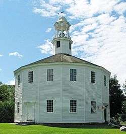
Round Church, completed in 1813 | |
 Location in Chittenden County and the state of Vermont. | |
 Richmond, Vermont Location in the United States | |
| Coordinates: 44°24′17″N 72°59′25″W / 44.40472°N 72.99028°WCoordinates: 44°24′17″N 72°59′25″W / 44.40472°N 72.99028°W | |
| Country | United States |
| State | Vermont |
| County | Chittenden |
| Incorporated | 1794 |
| Area | |
| • Total | 32.7 sq mi (84.8 km2) |
| • Land | 32.2 sq mi (83.5 km2) |
| • Water | 0.5 sq mi (1.4 km2) |
| Elevation | 289 ft (88 m) |
| Population (2010) | |
| • Total | 4,081 |
| • Density | 127/sq mi (48.9/km2) |
| Time zone | Eastern (EST) (UTC-5) |
| • Summer (DST) | EDT (UTC-4) |
| ZIP code | 05477 |
| Area code(s) | 802 |
| FIPS code | 50-59275[1] |
| GNIS feature ID | 1462186[2] |
| Website |
www |
Richmond is a town in Chittenden County, Vermont, United States. As of the 2010 census the population was 4,081.[3]
The main settlement of Richmond in the north-central part of town is a census-designated place (CDP), with a population of 723 at the 2010 census.[4]
History
In 1775, Amos Brownson and John Chamberlain made the first settlement attempt. They abandoned their efforts in the fall of that year, but returned in the spring of 1784, at the close of the Revolutionary War. Richmond was incorporated by the General Assembly on October 27, 1794, then organized in 1795. The Winooski River and Huntington River both offered locations for water mills. Industries began to manufacture wagons, harnesses, tinware, brass, cabinet work and woodenware. By 1859, the population was 1,453.
Richmond is noted for the Round Church, a rare 16-sided meetinghouse that was erected in 1812-1813.[5]
Geography
According to the United States Census Bureau, the town has a total area of 32.7 square miles (84.8 km2), of which 32.2 square miles (83.5 km2) is land and 0.54 square miles (1.4 km2), or 1.59%, is water.[3] Richmond is bisected by the Winooski River, with its tributary the Huntington River crossing the southeast corner of the town. Richmond is located in the western foothills of the Green Mountains.
The town is crossed by Interstate 89, with access from Exit 11 in the northwest part of town, by U.S. Route 2, and by the New England Central Railroad.
Schools
Local students attend Mount Mansfield Union High School, Camel's Hump Middle School and Richmond Elementary School. Mount Mansfield Union High is in the neighboring town of Jericho. The MMU athletic teams are the Cougars, who play the teams of neighboring schools such as CVU.
On November 4, 2014, the communities of Bolton, Jericho, Richmond, Underhill ID and Underhill Town voted to form the Mount Mansfield Modified Union School Districtm also known as the MMMUSD. This new school district will serve and govern the current town school districts of Bolton (Smilie Memorial School), Jericho (Jericho Elementary), Richmond (Richmond Elementary), Underhill ID School District (Underhill ID Elementary), Underhill Town (Underhill Central School), Mt Mansfield Union School District (Browns River Middle, Camels Hump Middle and Mt. Mansfield Union High Schools) in grades Pre-K through 12 and Huntington students grades 5-12.[6]
Demographics
| Historical population | |||
|---|---|---|---|
| Census | Pop. | %± | |
| 1800 | 718 | — | |
| 1810 | 935 | 30.2% | |
| 1820 | 1,014 | 8.4% | |
| 1830 | 1,109 | 9.4% | |
| 1840 | 1,054 | −5.0% | |
| 1850 | 1,453 | 37.9% | |
| 1860 | 1,400 | −3.6% | |
| 1870 | 1,309 | −6.5% | |
| 1880 | 1,264 | −3.4% | |
| 1890 | 1,115 | −11.8% | |
| 1900 | 1,057 | −5.2% | |
| 1910 | 1,419 | 34.2% | |
| 1920 | 1,447 | 2.0% | |
| 1930 | 1,315 | −9.1% | |
| 1940 | 1,225 | −6.8% | |
| 1950 | 1,278 | 4.3% | |
| 1960 | 1,303 | 2.0% | |
| 1970 | 2,249 | 72.6% | |
| 1980 | 3,159 | 40.5% | |
| 1990 | 3,729 | 18.0% | |
| 2000 | 4,090 | 9.7% | |
| 2010 | 4,081 | −0.2% | |
| Est. 2014 | 4,129 | [7] | 1.2% |
| U.S. Decennial Census[8] | |||
As of the census[1] of 2000, there were 4,090 people, 1,504 households, and 1,100 families residing in the town. The population density was 128.4 people per square mile (49.6/km2). There were 1,528 housing units at an average density of 48.0 per square mile (18.5/km2). The racial makeup of the town was 98.36% White, 0.05% African American, 0.12% Native American, 0.51% Asian, 0.02% Pacific Islander, 0.07% from other races, and 0.86% from two or more races. Hispanic or Latino of any race were 0.83% of the population.
There were 1,504 households out of which 41.2% had children under the age of 18 living with them, 62.2% were married couples living together, 7.8% had a female householder with no husband present, and 26.8% were non-families. 18.4% of all households were made up of individuals and 4.0% had someone living alone who was 65 years of age or older. The average household size was 2.71 and the average family size was 3.13.
In the town the population was spread out with 29.3% under the age of 18, 5.4% from 18 to 24, 34.1% from 25 to 44, 24.5% from 45 to 64, and 6.8% who were 65 years of age or older. The median age was 37 years. For every 100 females there were 95.7 males. For every 100 females age 18 and over, there were 96.0 males.
The median income for a household in the town was $57,750, and the median income for a family was $66,875. Males had a median income of $36,161 versus $30,019 for females. The per capita income for the town was $25,692. About 3.2% of families and 5.1% of the population were below the poverty line, including 6.2% of those under age 18 and 5.8% of those age 65 or over.
Notable people
- Barbara Cochran, Olympic alpine skier and member of the Skiing Cochrans
- George F. Edmunds, US senator
- Joel Furr, internet personality; coined the term spam
- Louis Greenough, pioneer and inventor
- Trey Anastasio, Lead singer & Guitarist of the rock band Phish; lived here previously.
- John Phillips, Wisconsin physician and politician[9]
- George Dallas Sherman, first leader of the Burlington Concert Band
References
- 1 2 "American FactFinder". United States Census Bureau. Archived from the original on September 11, 2013. Retrieved 2008-01-31.
- ↑ "US Board on Geographic Names". United States Geological Survey. 2007-10-25. Retrieved 2008-01-31.
- 1 2 "Geographic Identifiers: 2010 Census Summary File 1 (G001): Richmond town, Chittenden County, Vermont". U.S. Census Bureau, American Factfinder. Retrieved August 19, 2015.
- ↑ "Geographic Identifiers: 2010 Demographic Profile Data (G001): Richmond CDP, Vermont". U.S. Census Bureau, American Factfinder. Retrieved August 19, 2015.
- ↑ Richmond Historical Society. "Old Round Church". Retrieved 2010-02-01.
- ↑ Chittenden East Supervisory Union, http://www.cesu.k12.vt.us/
- ↑ "Annual Estimates of the Resident Population for Incorporated Places: April 1, 2010 to July 1, 2014". Retrieved June 4, 2015.
- ↑ "U.S. Decennial Census". United States Census Bureau. Archived from the original on May 11, 2015. Retrieved May 16, 2015.
- ↑ 'Proceedings of the State Historical Society of Wisconsin at it Annual Meeting,' Volume 51, Wusconsin Historical Society: 1904, Biographical Sketch of John Phillips, pg. 97
Further reading
External links
- Town of Richmond official website
- Richmond Free Library
- Richmond Historical Society
- Richmond Area Business Association
Municipalities and communities of Chittenden County, Vermont, United States | ||
|---|---|---|
| Cities | 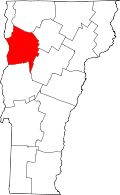 | |
| Towns | ||
| Villages | ||
| CDPs | ||
| Unincorporated communities | ||