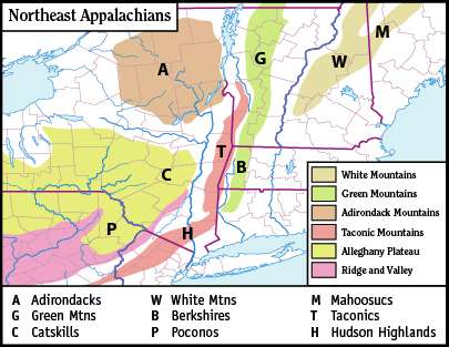
Green Mountains


The Green Mountains are a mountain range in the U.S. state of Vermont. The range runs primarily south to north and extends approximately 250 miles (400 km) from the border with Massachusetts to that with Quebec, Canada. The part of the range that is in Massachusetts and Connecticut is known as The Berkshires,[1] or the Berkshire Hills.[2] The Connecticut portion (Fairfield and Litchfield counties) of the Berkshires is also referred to by locals as either the Northwest Hills or Litchfield Hills, and the part in Quebec is called the Sutton Mountains, or Monts Sutton.[3]
All mountains in Vermont are often referred to as the "Green Mountains". However, other ranges within Vermont, including the Taconics — in southwestern Vermont's extremity — and the Northeastern Highlands, are not geologically part of the Green Mountains.
Peaks
The best-known mountains – for reasons such as high elevation, ease of public access by road or trail (especially the Long Trail and Appalachian Trail), or with ski resorts or towns nearby – in the range include:[4]
- Mount Mansfield, 4,393 feet (1,339 m), the highest point in Vermont
- Killington Peak, 4,241 feet (1,293 m)
- Mount Ellen, 4,083 feet (1,244 m)
- Camel's Hump, 4,083 feet (1,244 m)
- Mount Abraham, 4,017 feet (1,224 m)
- Pico Peak, 3,957 feet (1,206 m)
- Stratton Mountain, 3,940 feet (1,200 m), the mountain at which the initial ideas of both the Long Trail and the Appalachian Trail were born
- Jay Peak, 3,862 feet (1,177 m), receives the most amount of snowfall on average in the eastern United States[5][6]
- Bread Loaf Mountain, 3,835 feet (1,169 m)
- Mount Wilson, 3,780 feet (1,150 m)
- Glastenbury Mountain, 3,748 feet (1,142 m)
The Green Mountains are part of the Appalachian Mountains, a range that stretches from Quebec in the north to Alabama in the south.
The Green Mountains are part of the New England/Acadian forests ecoregion.[7]
Three peaks, Mount Mansfield, Camel's Hump, and Mount Abraham, support alpine vegetation.
Tourism
Some of the mountains are developed for skiing and other snow-related activities. Others have hiking trails for use in summer.[8] Mansfield, Killington, Pico, and Ellen have downhill ski resorts on their slopes. All of the major peaks are traversed by the Long Trail, a wilderness hiking trail that runs from the southern to northern borders of the state and is overlapped by the Appalachian Trail for roughly 1⁄3 of its length.
History
The Vermont Republic, also known as the Green Mountain Republic,[9] existed from 1777 to 1791, at which time Vermont became the 14th state.
Vermont not only takes its state nickname ("The Green Mountain State") from the mountains, it is named after them. The French Verts Monts is literally translated as "Green Mountains". This name was suggested in 1777 by Dr. Thomas Young, an American revolutionary and Boston Tea Party participant. The University of Vermont and State Agricultural College is referred to as UVM, after the Latin Universitas Viridis Montis (University of the Green Mountains).[10]
Geology and physiography
The Green Mountains are a physiographic section of the larger New England province, which in turn is part of the larger Appalachian physiographic division.[11]
Lemon Fair runs through the towns of Orwell, Sudbury, Shoreham, Bridport, and Cornwall, Vermont, before flowing into Otter Creek. The story is that its name derives from early English-speaking settlers' phonetic approximation of 'Les Monts Vert'.
See also
- Green Mountain National Forest
- Green Mountain Boys – paramilitary infantry led by Ethan Allen that took Fort Ticonderoga during the American Revolution
- Green Mountain Club
- Griffith Lake
References
- ↑ "The Mountains of Vermont". Saint Michael's College. Retrieved 7 September 2013.
- ↑ "Berkshire Hills". Geographic Names Information System. United States Geological Survey. Retrieved 27 November 2016.
- ↑ "Monts Sutton". Commission de toponymie Québec. Retrieved 7 September 2013.
- ↑ Peak elevations taken from "Mountain Peaks, Summits, and High Points". Retrieved 17 January 2010.
- ↑ Wheeler, Scott (February 2008). The Man Who Helped Electrify the Jay Peak Ski Area. Northland Journal.
- ↑ McLean, Dan (July 1, 2008). Investors purchase Jay Peak. Burlington Free Press.
- ↑ Olson, D. M, E. Dinerstein; et al. (2001). "Terrestrial Ecoregions of the World: A New Map of Life on Earth". BioScience. 51 (11): 933–938. doi:10.1641/0006-3568(2001)051[0933:TEOTWA]2.0.CO;2.
- ↑ Green Mountains (Vermont) : Climbing, Hiking & Mountaineering. SummitPost. Retrieved on 2013-07-12.
- ↑ See, e.g., Robert Temple, Edge Effects: The Border-Name Places (2008), p. 6; Paul Finkelman and Stephen E. Gottlieb, Toward a Usable Past: Liberty Under State Constitutions (University of Georgia Press, 2009), p. 375; Ralph Nading Hill, The College on the Hill: A Dartmouth Chronicle (Dartmouth Publications: 1965), pp. 46, 50; Vermont Historical Society, Vermont History, Vol. 66-67 (1998), p. 87.
- ↑ History and Traditions, University of Vermont.
- ↑ "Physiographic divisions of the conterminous U. S.". U.S. Geological Survey. Retrieved 2007-12-06.
External links
| Wikivoyage has a travel guide for Green Mountains. |
| Wikisource has the text of the 1879 American Cyclopædia article Green Mountains. |
- U.S. Geological Survey Geographic Names Information System: Green Mountains
 "Green Mountains". The New Student's Reference Work. 1914.
Subfields of physical geography | ||
|---|---|---|
 | ||
Montpelier (capital) | |
| Regions | |
| Counties | |
| Cities | |
| Towns (pop. >5000) | |
| Festivals | |
| Topics |
|
| Society |
|
Coordinates: 44°47′30″N 72°34′58″W / 44.79167°N 72.58278°W