Queens Quay (Toronto)
| |||||||
|---|---|---|---|---|---|---|---|
|
Looking east down Queens Quay, next to Ann Tindal Park. | |||||||
| Major junctions | |||||||
| West end: | Stadium Road | ||||||
| East end: | Parliament St | ||||||
| Location | |||||||
| Major cities: | Toronto | ||||||
| |||||||


Queens Quay is a prominent street in the Harbourfront neighbourhood of Toronto, Ontario, Canada.[1] The street was originally commercial in nature due to the many working piers along the waterfront; parts of it have been extensively rebuilt in since the 1970s with parks, condominiums, retail, and institutional and cultural development.
History
The road supplanted both Front Street and Lake Shore Boulevard as the most southerly east-west corridor in the city when it was created on reclaimed land in the inner harbour. Sometime after 1919 to the early 1920s the inner harbour was filled in and new slips were created.
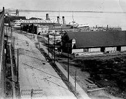
Queens Quay continues to go through a significant transformation. Originally, it served as an access road for the various ports and slips in the inner harbour. The street between Yonge Street and Parliament Street was home to storage buildings devoted to trade on the Saint Lawrence Seaway, major industries such as the Redpath Sugar Refinery and Victory Mills, as well as small commercial enterprises.[2] However, the mainly industrial uses along Queens Quay were slowly replaced by commercial and residential uses, mainly high-rise condominiums. Between 1975 and 1979, a cluster of large, concrete towers were erected at the foot of Bay Street, south of Queens Quay; these included the Westin Harbour Castle and Harbour Square. In 1990, the 40-storey York Quay towers were built and remain the tallest buildings on Queens Quay.[3] The scale and density of these and subsequent high-rise development along Queens Quay were criticized for blocking the lake and failing to provide a welcoming realm for visitors. In 1999, the Toronto Transit Commission opened a dedicated streetcar right-of-way in the median from Bay Street to Bathurst Street.
In 2001, the city planners set out to improve Queens Quay by reclaiming public space for pedestrians and cyclists. This resulted in the Waterfront Toronto Central Waterfront Public Realm International Design Competition, which was completed in 2006. In August 2006, the city closed the two eastbound lanes, replacing them with bike lanes as part of the Martin Goodman Trail and additional pedestrian space. The experiment resulted in an improved public realm and more visitors to the overall waterfront area.[4]
In 2009, Waterfront Toronto announced its plans to turn Queens Quay into a grand lakefront boulevard by placing streetcar lanes in the centre, traffic only on the north side and a pedestrian-focused space on the south side.[5] The plan will restrict Queen's Quay to two traffic lanes, on the north side of the streetcar tracks, similar to the design of the 2006 experiment. Additionally, the plan calls for the beautification and extension of the Harbourfront streetcar line along Queen's Quay East between Yonge and Cherry Street. The transit right-of-way will be grass-covered.[6][7]
In 2013 two open spaces opens, Ontario Square and Canada Square. The former is an open public space and the latter a green area. Both replace the former parking lot, which is now underground.[8]
Transportation
Queens Quay is served by two streetcar lines, operating on a dedicated right-of-way. The 509 Harbourfront and 510 Spadina both terminate at Union Station and run along Queens Quay from Bay Street, westward. At Spadina Avenue, the 510 heads north to Spadina Station, and the 509 continues west, bound for the Exhibition Loop.[9][10]
Originally there was to have been an underground station in front of the Westin Harbour Castle Hotel and the Toronto Island Ferry Docks,[11] with underground access to the hotel. This plan was cancelled when the hotel management became unwilling to share in the cost, and a smaller station was built around the corner under Bay Street.
Plans to add a Queens Quay East light rail line are the subject of a class environmental assessment.[12] Various bus routes currently serve portions of the eastern portion of Queens Quay: the 6 Bay operates from Bay Street to Jarvis Street, the 75 Sherbourne operates from Jarvis Street to Sherbourne Street, and the 97 Yonge and 320 Yonge Blue Night buses operate from Bay Street to Yonge Street.
Landmarks
| Landmark | Cross street | Notes | Image |
|---|---|---|---|
| Little Norway Park | Bathurst |  | |
| Canada Malting Silos | Bathurst | Abandoned storage silos since 1980s; germination and kiln buildings demolished 2010 | 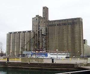 |
| Toronto Music Garden | Spadina |  | |
| Walter Carsen Centre | Spadina | headquarters of the National Ballet of Canada | 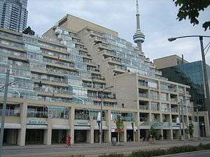 |
| Empire Sandy | Spadina | 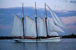 | |
| HTO Park | Spadina |  | |
| Toronto Waterfront WaveDecks | Spadina, Rees, Lower Simcoe |  | |
| Harbourfront Centre | Lower Simcoe | a cultural centre built by the federal government as part of the Harbourfront Park development |  |
| Queen's Quay Terminal | York | Built in 1926 as a cold storage warehouse facility turned into condos in the 1980s |  |
| Queens Quay Station | Bay | Underground LRT station |  |
| Westin Harbour Castle Hotel | Bay | Built in 1975 as Harbour Castle Hilton and became a Westin hotel in 1987 | 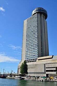 |
| World Trade Centre | Yonge |  | |
| Captain John's Harbour Boat Restaurant (1975-2015) | Yonge | Restaurant on a permanently docked boat (Restaurant closed 2011 and ship was removed from dock in May 28, 2015 for recycling in Port Colborne, Ontario) |  |
| One Yonge Street | Yonge | Toronto Star headquarters | 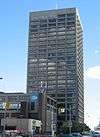 |
| Redpath Sugar Refinery | Jarvis | Last active industrial site along the quay | 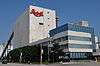 |
| The Guvernment | Jarvis | Night club opened in 1980s and closed 2015; demolition to begin in 2015 as property sold to condo developer Daniels Corporation | 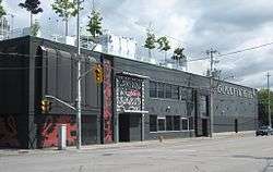 |
| Sugar Beach | Jarvis |  | |
| Corus Quay | Jarvis | Home of Corus Entertainment and first major development in the East Bayfront District |  |
| Victory Soya Mills Silos (Central Soya Mills) | Parliament | Built 1943 and abandoned industrial silos since 1991; designated historic site |  |
Quays and slips along Queens Quay
Listed from west to east
- Bathurst Quay (Éireann Quay) - see Ireland Park and Canada Malting Silos
- Spadina Quay
- Peter Street Slip
- Maple Leaf Quays - former site of Maple Leaf Mills Silos
- Rees Street Slip
- John Street Quay
- Simcoe Street Slip
- York Quay
- York Street Slip
- Harbour Square
- Yonge Street Slip
- Pier 27
- Jarvis Street Slip - now Corus Quay
- Redpath Slip
- Parliament Street Slip
References
- ↑ Jack Lakey (2014-01-23). "Streetcar rails test patience of Queens Quay pedestrians: The Fixer". Toronto Star. Archived from the original on 2014-01-24.
Those who know it only as the location of the island ferry docks or Sugar Beach might be surprised to learn that it was lined with warehouses until someone figured out it was some of Toronto’s best real estate.
- ↑ Filey, Mike (13 March 2010). "History on the waterfront". Toronto Sun. Retrieved 8 February 2011.
- ↑ Development
- ↑ Experiment Archived August 30, 2006, at the Wayback Machine.
- ↑ "City Council approves plan to transform Queens Quay." Canada NewsWire. Oct 1, 2009.
- ↑ Master Plan Archived May 11, 2013, at the Wayback Machine.
- ↑ John Spears (September 11, 2009). "Slow start for a new Queens Quay". The Star. Toronto. Retrieved February 7, 2011.
- ↑ The Star. Toronto http://www.thestar.com/news/gta/2013/06/21/new_on_torontos_waterfront_ontario_square_canada_square.html. Missing or empty
|title=(help) - ↑ James Bow. "Route 509 - The New Harbourfront Streetcar Archived March 4, 2016, at the Wayback Machine.." Transit Toronto. July 26, 2009
- ↑ James Bow. "Route 510 - The Spadina Streetcar Archived January 13, 2005, at the Wayback Machine.." Transit Toronto. November 10, 2006
- ↑ Peter Howell (1990-03-12). "TTC fighting on two fronts Province, Toronto give it rough ride". Toronto Star. p. A.15. Retrieved 2012-03-13.
The constant bickering between the TTC and Toronto over serving the ferry dock led to the recent decision by the owners of the Harbour Castle Westin to withdraw their $2.5 million share of the $4 million cost. The TTC now plans to build a smaller stop on the north side of Queens Quay, which means thousands of people will have to cross the busy street to take the ferries.
- ↑ www.ene.gov.on.ca Archived January 28, 2007, at the Wayback Machine.
External links
![]() Media related to Queens Quay, Toronto at Wikimedia Commons
Media related to Queens Quay, Toronto at Wikimedia Commons
Major roads, highways and streets in Toronto | |||||||||||
|---|---|---|---|---|---|---|---|---|---|---|---|
| North-south |
| ||||||||||
| East-west |
| ||||||||||
| |||||||||||
| |||||||||||