Bayview Avenue
| |||||||
|---|---|---|---|---|---|---|---|
| York Regional Road 34 | |||||||
|
Bayview within Toronto | |||||||
| Route information | |||||||
|
Maintained by City of Toronto Region of York | |||||||
| Length: | 17.5 km[1] (10.9 mi) | ||||||
| Major junctions | |||||||
| South end: | Mill Street in Toronto | ||||||
|
Queen Street East River Street Eglinton Avenue Lawrence Avenue Steeles Avenue | |||||||
| North end: | Water/Gorham Streets in Newmarket (Continues as Prospect Street) | ||||||
| Location | |||||||
| Major cities: |
Toronto Markham | ||||||
| Highway system | |||||||
| |||||||

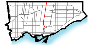
Bayview Avenue is a major north-south route in the Greater Toronto Area of Ontario. North of Toronto, in York Region, Bayview is also designated as York Regional Road 34.
History
Bayview Avenue follows the first concession line, laid 6,600 ft (2,000 m) east of Yonge Street. Over time, the concession road became known as East York Avenue, a reference to the division it formed between the city of Toronto and the township of East York.[2] In 1931, James Stanley McLean constructed Bay View overlooking the Don Valley on the edge of Moore Park.[3]
On August 17, 1959, Bayview was extended south from Moore Avenue in Leaside to Front Street. The northern section of this extension was routed alongside Pottery Road to Nesbitt Drive. South of this, it wraps around a hill and descends into the Lower Don Valley, travelling parallel to the route of the Don Valley Parkway.[4]

This addition is frequently referred to as the Bayview Extension. It was constructed as part of the Don Valley Parkway project, and necessitated the removal of "Sugarloaf Hill" directly north of the Bloor Street Viaduct. The extension fulfilled the "central spoke" in the building of the "Don Valley Roadway" as proposed in the 1940s. A route through the ravine to St. Clair Avenue was replaced with the present route which stays within the Don Valley proper. Bayview Avenue now terminates at the Corktown Common at Mill Street.
The list of street removed or used to create the extension included:
- Don Roadway West - from Front Street to Winchester Street
- Marriott - from north of Bloor Street beginning at Park Drive (now Park Drive Reservation Trail)
In the late 1990s, York Region conducted several road needs studies near Lake Wilcox, which determined that the disjointed and disconnected Bayview Avenue should be connected from Stouffville Road in the south to Bloomington Road in the north. A lengthy battle ensued between environmentalists, upset over continuing construction in the supposedly protected Oak Ridges Moraine. The discovery of Jefferson salamanders in the study area resulted in several modifications to the design of the route, including a 70 m (230 ft) structure over a dry ravine, as well as five amphibian tunnels. On November 17, 2002, the new extension was opened, including a widened intersection at Stouffville Road. The former route of Bayview was turned into several short streets, which lie directly west of the new roadway.[5]
Bayview Avenue was once proposed to be renamed Kilgour Avenue by the town of Leaside, after Joseph Kilgour, whose widow sold his farm, Sunnybrook, to the city of Toronto on the condition that it never be developed. Today, Sunnybrook Hospital and Sunnybrook Park occupy those lands. While Bayview was never renamed, a recently constructed street south of the hospital carries the name Kilgour Road today.
Route description
The southern end of Bayview Avenue starts at River Street (under Queen Street East). For the first part of its route northward it runs through the Don Valley, on the West side of the river opposite the Don Valley Parkway. Along this stretch a steep cliff separates it from neighbourhoods such as Cabbagetown.

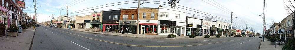
Bayview exits the Don Valley, passing through the Governor's Bridge neighbourhood and entering Leaside. It is the major commercial street for Leaside, home to many small shops and restaurants. North of Leaside Bayview runs across several tributaries of the Don River and is carried over one of them by the six-lane Bayview Bridge. This is the western portion of the wealthy Lawrence Park neighbourhood, and just to the east is the Bridle Path, the single wealthiest area of Toronto. A number of major institutions are found in this area including Sunnybrook Health Sciences Centre, Glendon College, Toronto French School, The Granite Club, The Crescent School, and the Bob Rumball Centre for the Deaf.
North of York Mills Avenue Bayview becomes one of the major north-south arterials for suburban North York. It passes through the neighbourhoods of Bayview Village, Bayview Woods, Willowdale, and Newtonbrook.
It runs north beyond Steeles Avenue, Toronto’s northern city limit, and continues north through York Region, where it is formally identified as York Regional Road 34. It is one of the main arterial roads for Thornhill and Richmond Hill. It then passes through the Oak Ridges Moraine, passing a number of parks and conservation areas. North of the moraine the street again enters urban areas, passing through Aurora and Newmarket. It ends in Newmarket where it turns into Prospect Street.
Bayview Avenue is also home to major places of worship of almost every major religious tradition including synagogues, an Islamic mosque, the city’s largest evangelical churches, Canada’s largest Buddhist Temple, Toronto’s largest Eastern Orthodox cathedral, and Canada’s only Zoroastrian Temple. These can all be found along a 15-kilometre section of the road.
Transit
Bayview Avenue south of Davisville has no transit service except for one block, but much of it runs parallel to the Richmond Hill GO Transit line.
North of Davisville, Bayview is served by the TTC's 11 Bayview bus route, which connects to the subway at Davisville and Bayview Stations. The 11 runs north to Steeles Avenue.
In York Region the 91 Bayview runs from Steeles to Wilcox Lake (also known as Lake Wilcox). The 54 Bayview then serves the street through Newmarket and Aurora.
Landmarks
| Landmark | Cross street | Notes | Image |
|---|---|---|---|
| Queen Street Viaduct | Queen St E |  | |
| Prince Edward Viaduct | Bloor St | Bayview runs under the viaduct | 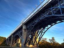 |
| Don Valley Brick Works | Pottery Road | 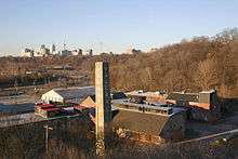 | |
| Crothers Woods | Nesbitt Dr |  | |
| Mount Pleasant Cemetery | Moore Ave | Bayview forms the eastern boundary of Canada's largest cemetery |  |
| St Cuthbert's Anglican Church | McRae Dr |  | |
| St. Augustine of Canterbury Anglican | Broadway Ave |  | |
| Mount Hope Catholic Cemetery | Kilgour Rd | 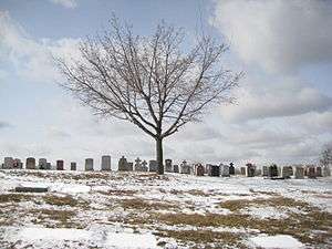 | |
| Sunnybrook Health Sciences Centre | Blythwood Rd | 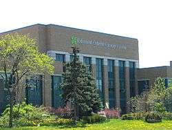 | |
| Lawrence Park Community Church | Dawlish Ave |  | |
| Glendon College | Lawrence Ave E | Campus of York University |  |
| Toronto French School | Lawrence Ave E |  | |
| Bayview Bridge | Lawrence Ave E | Carries Bayview across the Don Valley |  |
| The Granite Club | Lawrence Ave E | 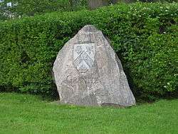 | |
| The Crescent School | Lawrence Ave E |  | |
| Bob Rumball Centre for the Deaf | Lawrence Ave E | ||
| Trinity York Mills Presbyterian Church | Highway 401 | 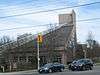 | |
| Bayview Station | Sheppard Ave | On the Sheppard line |  |
| Bayview Village Shopping Centre | Sheppard Ave |  | |
| United Synagogue Day School | Mckee Ave | ||
| St. Joseph's Morrow Park Catholic Secondary School | Cumner Ave | ||
| Shouldice Hernia Centre | John St | ||
| Thornlea Secondary School | Willowbrook Rd | ||
| Toronto Montessori Schools | Highway 7 | ||
| Bayview Secondary School | Major Mackenzie Dr |  | |
| Holy Trinity School | 19th Ave | ||
| Wilcox Lake | Bethesda Side Road |  | |
| Pickering College | Mulock Dr |
See also
References
- ↑ "Google Maps showing the entire length of Bayview Avenue within Toronto". Retrieved 2010-03-01.
- ↑ Filey, Mike (2004). "Origins of the Sheppard Subway Line". Toronto Sketches 8: The way we were. Dundurn Press. pp. 319–320. ISBN 1-55002-527-9.
- ↑ City of Toronto Archives
- ↑ Ontario Road Map (Map). Cartography by C.P. Robins. Ontario Department of Highways. 1959. § Toronto inset.
- ↑ Ferenc, Leslie (November 19, 2002). "Only memories left standing". Toronto Star.
| Wikimedia Commons has media related to Bayview Avenue, Toronto. |
Major roads, highways and streets in Toronto | |||||||||||
|---|---|---|---|---|---|---|---|---|---|---|---|
| North-south |
| ||||||||||
| East-west |
| ||||||||||
| |||||||||||
| |||||||||||