The Esplanade (Toronto)


The Esplanade is an east-west street along the central waterfront of Toronto, Canada. Originally conceived as a city beautification project to clean up the city's waterfront in the 1850s, the street was taken over by the coming of the railways to Toronto in 1850. The railway eventually moved to an elevated viaduct, leaving only the eastern section of the street today. The area, east of Yonge Street, was dominated by industrial uses until the second half of the 20th Century. As the harbour declined as a transfer point, the railway and industrial uses left the area. The Esplanade was redeveloped into a residential area, pioneered by the "St. Lawrence" 1970s/1980s low-rise housing project east of Jarvis. Along this leg of The Esplanade, the southern part of the street was converted to a long strip of park and recreation space for the residents. The stretch east of Yonge Street is a popular restaurant area.
Description
The Esplanade begins as a two-lane street at Yonge Street, south of Front Street, north of the railway viaduct. To the north is the Sony Centre for the Arts with the "L Tower" condominium tower wedged in behind. Going east, both sides of the street are lined with late 20th-Century or early 21st Century high-rise condominium projects. On the ground floors are numerous restaurants and retail stores. The north side of the street has a wide enough sidewalk that the restaurants have patios. Further to the east, along the north side are older industrial buildings, such as the Greey's Toronto Mill Furnishing Works Factory at # 70, which have been repurposed into commercial space. The street continues as a two-lane with wide north-side sidewalk east of Church Street as far west as Market Lane. Between here and Jarvis Street is the south building of St. Lawrence Market on the north side and the temporary location of the Market's farmer's market building.
From the east of Jarvis, The Esplanade is primarily residential, and primarily low-rise. The street is a two-lane road, with a large open space along the south side, used for park and recreation space. On the south side of the open space is the St. Lawrence housing development. Along the north side are various late 20th Century low-rise apartment projects. The St. Lawrence Recreation Centre is located along the north side of the street, east of Sherbourne, next to Market Lane Public School. This street form continues east to Berkeley Street, one block west of Parliament Street. On the north-west corner is the Berkeley Castle, the former 1871 Toronto Knitting & Yarn Factory, repurposed as commercial space.
History
In the 1840s, Toronto's waterfront was a combination of wharves and squatter buildings. The area where The Esplanade is today was then part of the harbour, south of the shoreline. The Esplanade, a 100 feet (30 m)-wide road, was proposed, just south of Front Street, with new water lots made from cribbing and filling of the shore to the south. The waterfront was extended to a survey line from the point of the Gooderham windmill west to a point due east of the old Fort Rouillé.[1] Ostensibly for carriages and carts, the roadway eventually became primarily the route for rail lines in the central core. In exchange for 40 feet (12 m) of the Esplanade, the railways underwrote the infilling of the harbour. The Esplanade and infill project was complete by 1865.[2] The project was the start of the railways taking over the entire Esplanade to the west of Yonge Street, and almost all of the harbour area.
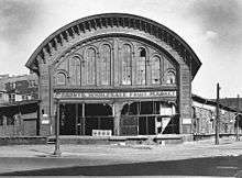
The Great Western Railway built its rail station at the intersection of Yonge Street and The Esplanade. After the viaduct was built and passenger rail operations moved to the Union Station to the west, the building was converted to a freight office, then to the Toronto Wholesale Fruit Market.[3] The location became part of the site for the new O'Keefe Centre for the Performing Arts (now the Sony Centre) in 1960. The Fruit Market and the wholesale market west of the St. Lawrence Market moved out of downtown to the Ontario Food Terminal by the Humber River to the west.
References
- Wickson, Ted (2002). Reflections of Toronto Harbour. Toronto, Ontario: Toronto Port Authority. ISBN 9780973000207.
Major roads, highways and streets in Toronto | |||||||||||
|---|---|---|---|---|---|---|---|---|---|---|---|
| North-south |
| ||||||||||
| East-west |
| ||||||||||
| |||||||||||
| |||||||||||