Colborne Street, Toronto

Colborne Street is a street running several hundred metres east of Yonge Street in downtown Toronto, Ontario, Canada. It crosses Victoria Street and Leader Lane, ending at Church Street. It is located between and parallel to King Street East and Wellington Street East. The street is notable for retaining several historic buildings built during the reign of Queen Victoria.[1]
In 1822 a two-storey building, Masonic Hall, with a cupola was built on what is now Colborne Street.[2]
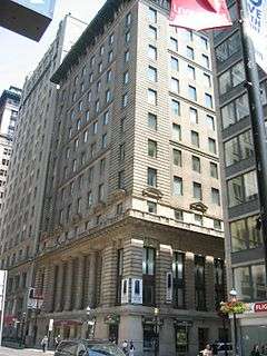
The 15 storey Trader’s Bank Building at the corner of Colborne and Yonge streets was the tallest building in the British Empire when it was built in 1906.[3]
In 1914 the King Edward Hotel requested a permit to build a pedestrian bridge across Colborne Street to an annex on the south side.[4]
References
- ↑ Amy Pataki (2007-02-17). "Colborne Street sizzles". The Star. Toronto. Archived from the original on 2012-01-10. Retrieved 2011-12-27.
The action is hot on Colborne St., the short and usually sleepy strip of Victoriana below King and Yonge.
- ↑ Henry Scadding Length (1873). Toronto of Old. p. 64. ISBN 978-1-55002-027-4. Retrieved 2012-02-05.
Across Church Street from Clinkenbroomer's were the wooden buildings already referred to as having remained long in a partially finished state, being the result of a premature speculation. From this point we are induced to turn aside from our direct route for a few moments, attracted by a street which we see a short distance to the south, namely Market Lane, or Colborne Street, as the modern phraseology is.
- ↑ "Yonge Street" (PDF). Toronto Heritage. Retrieved 2011-12-28.
Trader’s Bank Building (1906) – Just south of the corner of Yonge and King Streets, the first skyscraper built in Toronto opened as the tallest building in the British Empire. It anchors a group of neighbouring skyscrapers built in the World War I era and later.
- ↑ "King Edward want to build bridge". Toronto Sunday World. 1914-02-14. p. 9. Retrieved 2011-12-27.
Coordinates: 43°38′56″N 79°22′33″W / 43.64890°N 79.3758°W
Major roads, highways and streets in Toronto | |||||||||||
|---|---|---|---|---|---|---|---|---|---|---|---|
| North-south |
| ||||||||||
| East-west |
| ||||||||||
| |||||||||||
| |||||||||||