Point Breeze, Philadelphia
| Point Breeze | |
|---|---|
| Neighborhood of Philadelphia | |
|
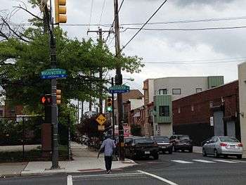
Point Breeze Avenue street sign at its northern terminus at Federal and 20th streets. | |
| Country |
|
| State | Pennsylvania |
| County | Philadelphia County |
| City | Philadelphia |
| ZIP Code | 19145, 19146 |
| Area code(s) | Area code 215 |

Point Breeze is a multicultural neighborhood in South Philadelphia in Philadelphia, Pennsylvania, United States. It is bounded by 25th Street to the west, Washington Avenue to the north, Broad Street to the east, and Mifflin Street to the south. Southwest Center City lies to its north, and Passyunk Square lies to its east. Point Breeze is separated from Grays Ferry to the west by a CSX railway viaduct over 25th Street.
History
According to historical maps, much of what is South Philadelphia including Point Breeze was still not yet developed and integrated into the rectilinear grid system by 1843 or later.[1] "Point Breeze" was a point on the western side of the Schuylkill River approximately where the Passyunk Avenue bridge is today. It and the area across from it on the eastern side of the river were established as an area for oil refinery in the 1860s by Atlantic Petroleum Storage Company, later the Atlantic Refining Company. From this point, oil that had been drilled in Western Pennsylvania could be processed and then shipped down the Schuylkill, to the Delaware and out to sea.[2] The Avenue that connected the city proper to the east side of the river at Point Breeze had existed by 1808 as "Long Lane." [1] In the mid to late 1800s development of Philadelphia continued westward from the Delaware River and southward from Market Street. Long Lane also began to be known as Point Breeze Avenue by 1895[1] and lent its name to the neighborhood that was to spring up here. "The earliest references to Point Breeze" as a neighborhood "date to 1895."[3] The area was first settled by working-class European Jewish immigrants followed by Italian and Irish immigrants. In 1930s the neighborhood saw an influx of African Americans some of which were involved in The Great Migration escaping Jim Crow in the South and looking for work in the urban centers of the north. At this time the African American epicenter of Philadelphia was shifting from near Mother Bethel African Methodist Episcopal Church at 6th and Lombard to west of Broad.[4]
Through the 1960s Point Breeze was reported to be a safe, clean, relatively integrated and self-sufficient neighborhood with a thriving business district along Point Breeze Avenue itself known to residents as "The Breeze." Racial tensions, fear of race riots and white flight in the 1960s and '70s saw many businesses move away and shifted the demographics of the neighborhood to mostly African American. The heroin epidemic of the 70's and crack epidemic of the '90s and its related crime also affected Point Breeze. Between 1988 and 1990 the Philadelphia Police department performed a series of raids in Point Breeze effectively shutting down the Carr family drug ring which reportedly had been selling $1.3 million per year in crack, cocaine and prescription drugs.[5][6][7] The Point Breeze Performing Arts Center opened in 1984 on Point Breeze Avenue.[8] Point Breeze lost approximately 10% of its population from 1990 through 2000.[9] Despite this, in the 90's some revitalization efforts have taken place through such organizations as South Philadelphia H.O.M.E.S. and Universal Companies, owned by Kenny Gamble, whom helped build low income housing and schools in the area. Immigrants from Southeast Asia have also moved into Point Breeze in the '90s and 2000s. For example, in the 2000 census Point Breeze contained the highest concentration of Vietnamese in the entire city; over 900 Vietnamese people making up almost 12% of the population of Point Breeze.[10]
In the 2000s and beyond Point Breeze has shown further revitalization partially due to gentrification. Real estate investors like John Longacre and Ori Feibush have begun developing property in Point Breeze, especially along the Broad Street and Washington Avenue corridors.[11][12]
The George W. Childs School, David Landreth School, Marine Corps Supply Activity, Delaplaine McDaniel School, Jeremiah Nichols School, Walter George Smith School, and the former Francis M. Drexel School are listed on the National Register of Historic Places.[13]
Name origin
'Point Breeze' was originally the name given to a spot on the west side of the Schuylkill River. Point Breeze Avenue then became the road that cut southwest to provide access to the spot from what was at the time Philadelphia proper. The avenue cuts diagonally through the neighborhood's rectilinear street grid.
Social issues
The Point Breeze neighborhood suffered from abandonment and population decline throughout the mid 20th century. Today it is a neighborhood under revitalization from efforts steered by South Philadelphia H.O.M.E.S. Inc. and the Point Breeze Community Development Coalition Inc., in addition to such organizations as Neighbors in Action, Universal Companies, Point Breeze Business Association, Point Breeze Pioneers greening group and other prominent Philadelphia organizations.[14]
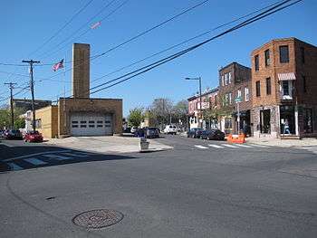
Cityscape
Point Breeze is south of Grays Ferry Avenue, north of Passyunk Avenue, and east of the Schuylkill River.[15]
Culture
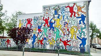
Point Breeze is home to several Philadelphia Mural Arts Program murals. In 1987 Keith Haring collaborated with CityKids a New York-based youth organization to create a mural titled "We Are The Youth" located at 22nd and Ellsworth in Point Breeze. In 2013 the Mural Arts program restored the mural and a small community garden was built beneath it.[16][17]
Education
Residents are zoned to the School District of Philadelphia.[15] There are 4 catchment areas in Point Breeze. Delaplaine McDaniel School K–8 (named after the Quaker merchant) at 22nd & Moore serves the westernmost catchment, Edwin M. Stanton School K-8 (named after the Secretary of War under Lincoln) at 17th & Christian serves the northernmost catchment and George W. Childs School K–8 (named after the publisher) at 16th & Wharton serves the easternmost catchment. All of the students in these three catchment areas are eligible to attend South Philadelphia High School. (Norris S. Barratt middle school was formerly the name of the school at 16th & Wharton but it closed in 2011 due to declining enrollment.[18] The former George W. Childs elementary school built in 1894 at 17th & Tasker was placed on the National Register of Historic Places in 1988 but was shuttered in 2010 and its fate remains uncertain.[19][20]) The southernmost catchment of Point Breeze attends Stephen Girard School K–4 (named after the wealthy banker) at 18th & Snyder, Universal Institute Charter School at Vare 5–8 at 24th & Snyder and Universal Institute Charter School at Audenried 9-12 at 33rd & Tasker.[21]
Infrastructure and government
The United States Postal Service operates the Point Breeze Post Office at 2500 Snyder Avenue.[22]
The Philadelphia Police Department's 17th District station is at the northern terminus of Point Breeze Avenue where it intersects 20th & Federal.[23]
The Free Library of Philadelphia operates two branches in Point Breeze: the South Philadelphia Branch at Broad and Morris and the Queen Memorial Library at 23rd & Federal (located in the Landreth Apartments for seniors).[24] On May 9th, 2016 the $45.2 million, 96,000-square foot, LEED-certified South Philadelphia Community Health and Literacy Center officially opened at Broad and Morris Streets in Point Breeze. It houses the new South Philadelphia library branch, a CHOP pediatric primary care center, a Philadelphia Department of Public Health community health center, and a new DiSilvestro Playground and Recreation Center.[25][26]
Point Breeze has several indoor and outdoor recreational areas:[27]
- Chew Playground and Recreation Facility, 19th & Washington
- Wharton Square and Recreation Facility, 23rd & Wharton
- DiSilvestro Playground and Recreation Facility, 15th & Morris
- Smith Playground and Recreation Facility/Wilson Park, 24th & Snyder
Notable Residents
- Tariq Trotter, a.k.a. Black Thought, rapper with Grammy award winning hip-hop group The Roots, from 23rd & Watkins
- Rasual Butler, NBA basketball player, from 20th & Manton
- Dwight Grant a.k.a. Beanie Sigel, rapper, from 22nd & Sigel
- H. Patrick Swygert, former president of Howard University, from 15th & Wharton
- The Heath Brothers, jazz trio
- Gene Perret, TV writer, of Sigel St.
- Richie Rome, producer, arranger & conductor, from 20th & Tasker
- Anthony Burrell, dancer who taught and choreographed at Point Breeze Performing Arts Center, from 22nd & Dickinson
- Anna C. Verna, former president of Philadelphia City Council, from 22nd & Dickinson
- Mamie Nichols, local community activist [9]
See also
- Francis M. Drexel School, formerly located in Point Breeze
References
- 1 2 3 Greater Philadelphia GeoHistory Network
- ↑ "The place where you live: Point Breeze", South Philly Review October 7, 2004
- ↑ "Point Breeze", "The PhillyHistory Blog:Discoveries from the City Archives," August 5, 2010
- ↑ "House Is Seized, Sealed As Site Of Open Drug Sales", "The Philadelphia Inquirer," June 29, 1989
- ↑ "This Drug Operation, Police Say, Was A Family Affair", "The Philadelphia Inquirer," July 9, 1989
- ↑ "Alleged Drug Family Raided", "The Philadelphia Inquirer," March 9, 1990
- ↑ "Neighborhood: Point Breeze", "Center City District + Central Philadelphia Development Corporation"
- 1 2 "Community Profile: Point Breeze, "South Philly Review"]
- ↑ "Recent Trends in Immigration to Philadelphia, Pennsylvania: Who came and where do they live?", "Pennsylvania University Arts & Sciences Fels Institute of Government," Christopher Patusky & Johnny Ceffalio, August 2004, p. 29
- ↑ "American Sardine Bar’s John Longacre: It’s Not About Race and Class", "Philadelphia Magazine," May 20, 2013
- ↑ "Changing Skyline: Savvy marketing, social media skills are keys for Point Breeze development". The Philadelphia Inquirer. 23 February 2013.
- ↑ National Park Service (2010-07-09). "National Register Information System". National Register of Historic Places. National Park Service.
- ↑ Fact Sheet - Point Breeze
- 1 2 "Philadelphia Neighborhoods and Place Names, L-P." City of Philadelphia. Retrieved on October 4, 2011. "East of Schuylkill River, north of Passyunk Avenue, south of Grays Ferry Avenue. "
- ↑ "Keith Haring Mural Philadelphia Gets Makeover", "AP," October 30, 2013
- ↑ "'We the Youth' recreates Keith Haring's vision", "South Philly Review," November 7, 2013
- ↑ "Farewell to Barratt", "South Philly Review," June 23, 2011
- ↑ "Plan Philly: Vacant School Buildings Affect Surrounding Communities", "Philadelphia Neighborhoods," December 6, 2012
- ↑ "Point Breeze: Plans Uncertain for Future of Former G.W. Childs Community School Building", "Philadelphia Neighborhoods," December 12, 2013
- ↑ "The School District of Philadelphia School Finder"
- ↑ "Post Office Location - POINT BREEZE." United States Postal Service. Retrieved on December 4, 2008.
- ↑ "Philadelphia Police Department Districts"
- ↑ "The Free Library Of Philadelphia Branches"
- ↑ "South Philly center combines health, literacy, recreation", Philly.com
- ↑ "CHOP opens new health center, library, rec center all in one", The Metro
- ↑ "City of Philadelphia Parks & Recreation"
External links
- South Philadelphia Review
- Philadelphia City Paper - City Paper article on violence in the area
- - City Paper article on greening efforts in the area
- Philly Skyline photos of Point Breeze
- Historic Photographs of Point Breeze, PhillyHistory.org
- National Shrine of Saint Rita of Cascia, US Catholic reliquary for Rita of Cascia
Coordinates: 39°56′05″N 75°10′53″W / 39.93482°N 75.18146°W