Hunting Park, Philadelphia
| Hunting Park | |
|---|---|
| Neighborhood of Philadelphia | |
|
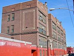
Bayard Taylor Elementary School is located in Hunting Park. | |
| Country |
|
| State | Pennsylvania |
| County | Philadelphia County |
| City | Philadelphia |
| Area code(s) | Area code 215 |
Hunting Park is a neighborhood in the North Philadelphia section of the United States city of Philadelphia, Pennsylvania.
In 2005, the 19140 zip code, which roughly consists of Hunting Park and Nicetown–Tioga, had a median home sale price of $39,650.
The Clara Barton School, Alexander K. McClure School, and Bayard Taylor School are listed on the National Register of Historic Places.[1]
History
In the years leading up until 2010 Hunting Park residents began a campaign against crime.[2]
Cityscape
Hunting Park is located north of Sedgley Avenue, east of the former SEPTA R7 railroad line, south of Roosevelt Boulevard, and west of Front Street.[3] Bordering neighborhoods include Logan to the north, Feltonville to the east, Fairhill to the south, and Nicetown–Tioga to the southwest.
Demographics
As of the 2010 Census, Hunting Park was 56% Hispanic of any race, 38.1% non Hispanic black, 2.9% non Hispanic white, 1.9% Asian, and 2.1% all other. The neighborhood is primarily made up of Puerto Ricans, Dominicans, and African Americans.[4]
Parks and recreation
Hunting Park, a 87-acre (35 ha) portion of Fairmount Park, lies in the Hunting Park neighborhood. Tara Murtha of Philadelphia Weekly said "For generations, Hunting Park served as the heart of the community. Then, about 25 years ago [before 2010], it became its noose."[2] Joann Taylor, a member of the Hunting Park Neighborhood Advisory Committee (NAC), said, as paraphrased by Murtha, "By the late '80s, the park was all but lost to hard-working members of the community. But soon community activist groups sprung up out of the negativity."[5]
Government and infrastructure
The United States Post Office operates the Hunting Park Post Office at 4350 North Front Street.[6]
Education

The School District of Philadelphia serves Hunting Park. For elementary school the area is served by the Alexander K. McClure Elementary School (K-5) in Hunting Park,[7][8] and the Bayard Taylor Elementary School (K-5) in Hunting Park.[9][10] It is also served by Clemente Middle School (5-8),[11] and Olney High School (9-12).[12]
Notable residents
- Kaboni Savage (murderer and drug dealer)[13]
References
- ↑ National Park Service (2010-07-09). "National Register Information System". National Register of Historic Places. National Park Service.
- 1 2 Murtha, Tara. "Hunting Park Bounces Back." Philadelphia Weekly. January 5, 2010. 1. Retrieved on February 1, 2013.
- ↑ "Philadelphia Neighborhoods and Place Names, A-K." City of Philadelphia. Retrieved on February 2, 2013.
- ↑ "American FactFinder". United States Census Bureau. Archived from the original on September 11, 2013. Retrieved 2008-01-31.
- ↑ Murtha, Tara. "Hunting Park Bounces Back." Philadelphia Weekly. January 5, 2010. 3. Retrieved on February 2, 2013.
- ↑ "Post Office Location - HUNTING PARK." United States Post Office. Retrieved on January 16, 2009.
- ↑ "Home." (Archived March 24, 2013, at the Wayback Machine.) McClure Elementary School. Retrieved on February 2, 2013. "Welcome to Alexander K. McClure Elementary School! We are located at the corner of 6th Street and Hunting Park Avenue in the Hunting Park section of North Philadelphia"
- ↑ "Alexander K. McClure Elementary School Geographic Boundaries." (Archived March 28, 2012, at the Wayback Machine.) School District of Philadelphia. Retrieved on February 2, 2013.
- ↑ Scott, Katherine. "Hamels Foundation pays to rehab Phila. playground." ABC 6 Action News. Wednesday August 8, 2012. Retrieved on February 2, 2013. "They paid to rebuild a playground, make a greenhouse, paint a mural and much more at Bayard Taylor Elementary school in Hunting Park."
- ↑ "Bayard Taylor Elementary School Geographic Boundaries." (Archived March 28, 2012, at the Wayback Machine.) School District of Philadelphia. Retrieved on February 2, 2013.
- ↑ "Roberto Clemente Middle School Geographic Boundaries." (Archived March 28, 2012, at the Wayback Machine.) School District of Philadelphia. Retrieved on February 2, 2013.
- ↑ "Olney High School Geographic Boundaries." (Archived March 28, 2012, at the Wayback Machine.) School District of Philadelphia. Retrieved on February 2, 2013.
- ↑ Anastasia, George; Maria Panaritis (2004-04-14). "Phila. man charged in cocaine ring Kaboni Savage was arrested yesterday. He was acquitted of murder last month.". Philadelphia Inquirer. Retrieved 2016-08-16.
Coordinates: 40°01′06″N 75°07′31″W / 40.0183°N 75.1252°W