Northwest Philadelphia
| Northwest Philadelphia | |
|---|---|
| Neighborhood of Philadelphia | |
|
Manayunk skyline in the Roxborough-Manayunk district in Northwest Philadelphia | |
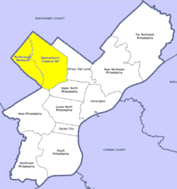 Map of Philadelphia County with Northwest highlighted neighborhood. Click for larger image. | |
| Country |
|
| State |
|
| County |
|
| City |
|
| Population (2010) | |
| • Total | ~170,000~ |
| ZIP codes | 19118,19119,19128,19129,19138,19144 |

Northwest Philadelphia is a section of the city of Philadelphia, Pennsylvania. The official boundary is Stenton Avenue to the north, the Schuylkill river to the southwest, Northwestern Avenue to the northwest, Roosevelt Boulevard to the south, and Wister Street and Stenton Avenue to the east. The area is divided by Wissahickon Creek into two subsections, Upper Northwest and Lower Northwest Philadelphia. Upper Northwest are Germantown, Mount Airy (which itself is divided into east and west), and Chestnut Hill, and Lower Northwest are Roxborough, East Falls, and Manayunk. Some of them informally comprise smaller neighborhoods. The Philadelphia Police Department patrols two districts located within Northwest Philadelphia. The two patrol districts serving Northwest Philadelphia are the 5th and 14th districts.[1]
Demographics and culture
Northwest Philadelphia has substantial African American, Irish-American, German-American, Italian-American, and British American (English American/Scottish American) populations, but its culture is varied, and only smaller neighborhoods within it can be said to be known for one ethnicity predominating.
Compared with other sections of Philadelphia, a substantial portion of the Northwest retains a more suburban feel, particularly Chestnut Hill, West Mount Airy, parts of East Falls, East Mount Airy and Germantown, and Upper Roxborough. For example, in East Falls one will find large Tudor homes and big modern ranch homes on sizable properties only blocks from more humble townhouses and rowhouses. Upper Roxborough boasts post-World War II suburban housing developments, while Lower Roxborough consists mostly of rowhouses and urban twin houses, apartments over storefronts, etc. There are also blocks of large Victorian homes peppered among the rowhouses. The mix of development is interesting for its contrasts; whereas in some spots, the buildings and street grid have existed for three centuries, other spots nearby were farmland until after World War II, and have infrastructure that is very recently developed and suburb-like. To travel from Germantown to Manayunk to Upper Roxborough is somewhat like traveling along a development timeline, from 18th-century farmhouses to 19th-century rowhomes to 20th-century shopping centers. Besides time, the other noticeable axis along which one can travel is socioeconomic. From an enclave of working-class Germantown rowhomes to the wealthy estates of Chestnut Hill, both may have been built in the period of 1880-1920, but the time period is all that they share.
Terrain and geography
Northwest Philadelphia is known for its hilly terrain, especially in the western half between the Wissahickon and the Schuylkill River. This hilly terrain is a distinct characteristic of Manayunk and Roxborough, making them popular for any recreation that can use a good hill (such as sledding and soapbox derbies, or especially challenging sessions of running and biking). Upper Roxborough, because it is one of the highest elevations in Philadelphia, is the site of a reservoir and many of the city's broadcast transmission towers. Ridge Avenue follows the ridge that divides the Wissahickon valley from the Schuylkill valley.
Learning to navigate successfully across and beyond Northwest Philadelphia requires one to keep in mind that Northwest Philadelphia's street grid is oriented along axes of northeast-southwest and northwest-southeast (X). These axes are skewed almost exactly 45° from the true north-south and east-west axes of Philadelphia's main street grid (+). Within any one neighborhood, it is easy to mentally discount the east-west gradient and think solely in terms of north-south, uphill-downhill, or (perhaps worst) to conflate those two, with the mental axis of "up"-"down" concealing the conflation. Any time that one begins to extrapolate too far along these lines, one is losing orientation with surrounding areas.
Northwest Philadelphia is an area where exceptions to the regular pattern of the street grid are plentiful. The Wissahickon gorge rather thoroughly divides the "halves" of Northwest Philadelphia because of the relative scarcity of road crossings. The rail lines tend to rather thoroughly divide adjacent neighborhoods, for the same reason. One-way streets are not uncommon, and neither is the event of a bend interspersed within the rectangular street grid. Manayunk's street grid evolved completely independently from Germantown's, which makes perfect sense from a historical perspective. The result of all these factors is that navigating in Northwest Philadelphia can be a very different experience depending on whether one is traveling by motor vehicle or on foot or bicycle. Navigating solely by motor vehicle can leave one with a rather distorted sense of how far away certain points are from each other. When one explores on foot or bike, one restores a more accurate sense of orientation.
References
| Wikivoyage has a travel guide for Northwest Philadelphia. |
- ↑ "Police Districts". Philadelphia Police Department. Retrieved 4 May 2012.
Coordinates: 39°59′00″N 75°11′21″W / 39.98343°N 75.18905°W