Bridesburg-Kensington-Richmond, Philadelphia
| Bridesburg-Kensington-Richmond | |
|---|---|
| Neighborhood of Philadelphia | |
|
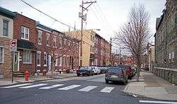
1500 block of E. Berks Street, a typical residential street in Fishtown, in 2007 in the Bridesburg-Kensington-Richmond planning district | |
 Map of Philadelphia County with Northeast highlighted, which contains the Bridesburg-Kensington-Richmond neighborhood. Click for larger image. | |
| Country |
|
| State |
|
| County |
|
| City |
|
| Area | |
| • Total | 8.49 sq mi (22.0 km2) |
| Population (2010) | |
| • Total | 88,452 |
| • Density | 10,417/sq mi (4,022/km2) |
| ZIP code | 19124, 19125, 19137 |
The Bridesburg-Kensington-Richmond section of Philadelphia is the area northeast of Center City. This area "... consists of the neighborhoods including: Bridesburg, Fishtown, Juniata Park, New Kensington, North West Kensington, Harrowgate, Port Richmond and Richmond..." and "... was once predominantly industrial. However, most heavy industry has now left."[1] According to an official Philadelphia parks agency, the official designation of "Bridesburg-Kensington-Richmond" by the planning commission is reflected in the way the parks system is set up.[2]
On May 12, 2015 an Amtrak train derailed in Harrowgate.
Demographics
The demographics of Bridesburg-Kensington-Richmond shows that the area has a population 151,862, with 71,591 males, 80,268 females and a median age of 33.[3]
Racial demographics[4][5]
- Non-Hispanic White: 36,442 (41.2%)
- Hispanic or Latino of any race: 30,958 (35.0%)
- Non-Hispanic Black: 13,002 (14.7%)
- Asian: 5,218 (5.9%)
- Mixed or Other: 2,830 (3.2%)
References
- ↑ "Bridesburg - Kensington– Richmond".
- ↑ "Swimming Pools".
- ↑ "Kensington - Richmond, Philadelphia, PA".
- ↑ Factfinder at census.gov
- ↑ "2010 Census". Medgar Evers College. Archived from the original on 2010-06-11. Retrieved 2010-04-13.

Coordinates: 39°58′59″N 75°05′35″W / 39.983°N 75.093°W