Pitou, Changhua
| Pitou 埤頭 | |
|---|---|
| Rural township | |
| Pitou Township · 埤頭鄉 | |
| Chinese transcription(s) | |
| • Traditional | 埤頭鄉 |
| • Pinyin | Pítóu Xiāng |
 Pitou | |
| Coordinates: TW 23°52′39″N 120°28′14″E / 23.87750°N 120.47056°ECoordinates: TW 23°52′39″N 120°28′14″E / 23.87750°N 120.47056°E | |
| Country | Taiwan |
| County | Changhua |
| Government | |
| • Mayor | Chen Cang Giong |
| Area | |
| • Total | 42.75 km2 (16.51 sq mi) |
| Population (December 2014) | |
| • Total | 31,045 |
| • Density | 730/km2 (1,900/sq mi) |
| Postal code | 523 |
| Website |
www |

Pitou Township (Chinese: 埤頭鄉; pinyin: Pítóu Xiāng) is a rural township in Changhua County, Taiwan. The district has a population total of 31,045 and an area of 42.75 square kilometres (16.5 sq mi). One of the attractions in Pitou is the Kopok Flower Boulevard.[1]
Administrative divisions
Heli Village, Xingnong Village, Beitou Village, Lilun Village, Lunzi Village, Yongli Village, Gexing Village, Pingyuan Village, Lunjiao Village, Yuanpu Village, Fuzhao Village, Xinzhuang Village, Liujia Village, Zhuwei Village, Zhonghe Village, Zhuangnei Village, Dahu Village.
Education
Tourist attractions
Nanyun Temple in Pitou is one of the stops on the annual Dajia Matsu pilgrimage.[2]
Transportation
Pitou is adjacent to National Highway No. 1, with Zhangshui Road another major arterial route through the township. Pitou's location around major highways plays an important role in facilitating transportation of the township's agricultural produce.
See also
| Wikimedia Commons has media related to Pitou Township, Changhua County. |
References
- ↑ Leisure and Tour, Changhua Pitou Country.
- ↑ Buchan, Noel: Walking with Matsu, Taipei Times, 7 April 2011.
External links
- Pitou Government website (English)
Cities and townships of Changhua County | ||
|---|---|---|
| Cities | 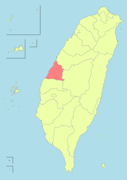 | |
| Urban townships | ||
| Rural townships | ||