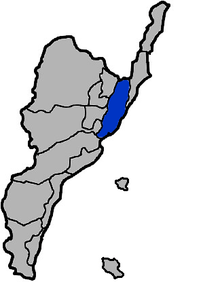
Donghe, Taitung
Coordinates: 22°58′N 121°15′E / 22.967°N 121.250°E
%2C_7-Eleven_stores_in_Taiwan_Shops_in_Donghe%2C_Taiwan.JPG)

Donghe Township (Chinese: 東河鄉; pinyin: Dōnghé Xiāng; Wade–Giles: Tung1-ho2 Hsiang1; literally: "east river township") is a rural township located in northeastern Taitung County, Taiwan.
History
Donghe Township has an old name of Fafukod (馬武窟), which means "fishing by net" in Amis language. Under Qing dynasty rule, the township was under jurisdiction of Pi-lam Subprefecture (卑南廳) and "Taitung direct-controlled state" (臺東直隸州) jurisdiction.
In 1920, during the period of Japanese rule, Toran local office (都蘭區役場) was set up. In 1937, it was changed to Toran Village (都蘭庄), under Shinkō District (新港郡), Taitō Prefecture. The name "Donghe Township" was established after World War II and is currently used.
Geography
It is bounded on the northeast by Chenggong, east by Pacific Ocean, west by neighboring Chihshang Township, Guanshan Township, and Luye Township, and south by Beinan Township.
This township is located on the east side of coastal mountain range. It includes 60% of the hillside onshore, divided into coastal and basin areas with gradual upland slopes merging into relatively flat sea stage plains, the area of major development. Basin streams are mainly north-south because of the difficult terrain. Climate is tropical monsoon climate.
Rural residents are Taiwanese aboriginal Ami mainly. The major industry is agriculture.
Administrative divisions
- Doulan Village
- Xingchang Village
- Longchang Village
- Tunghe Village
- Taiyuan Village
- Beiyuan Village
- Shangde Village
Education
Junior High Schools
Elementary Schools
- Donghe Elementary School, Dongher Township, Taiwan East County
- Dulan Elementary School, Donghe Township, Taitung County
- Sinlong School,Donghe Township, Taitung County
- Taiyuan Elementary School, Donghe Township, Taitung County
Tourist attractions
- Dulan Mountain
- Dulan Site
- Jinzun Fish Port[1]
- Old Donghe Bridge
Transportation
See also
| Wikimedia Commons has media related to Donghe Township, Taitung. |
References
External links
- 東河鄉公所 (Chinese)
Cities and townships of Taitung County | ||
|---|---|---|
| Cities |  | |
| Urban townships | ||
| Rural townships | ||
| Mountain indigenous townships | ||
Taiwanese aboriginal areas | ||||||||||||||||||||||||||||||||||||||||||||||||
|---|---|---|---|---|---|---|---|---|---|---|---|---|---|---|---|---|---|---|---|---|---|---|---|---|---|---|---|---|---|---|---|---|---|---|---|---|---|---|---|---|---|---|---|---|---|---|---|---|
| Highland aboriginal Townships and Districts |
| 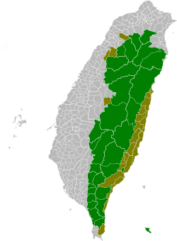 | ||||||||||||||||||||||||||||||||||||||||||||||
| Plains aboriginal Townships and County-Controlled Cities |
| |||||||||||||||||||||||||||||||||||||||||||||||
Note: On the map, "Highland aboriginal areas" are in green, and "Plains aboriginal areas" are in tan. | ||||||||||||||||||||||||||||||||||||||||||||||||