Pingtung County
| Pingtung County 屏東縣 | |||
|---|---|---|---|
| County | |||
 | |||
| |||
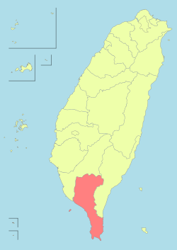 Pingtung County in Taiwan | |||
| Coordinates: 22°40′31.78″N 120°29′29.09″E / 22.6754944°N 120.4914139°ECoordinates: 22°40′31.78″N 120°29′29.09″E / 22.6754944°N 120.4914139°E | |||
| Country | Taiwan | ||
| Region | Southern Taiwan | ||
| Seat | Pingtung City | ||
| Largest city | Pingtung City | ||
| Boroughs | 1 cities, 32 (3 urban, 29 rural) townships | ||
| Government | |||
| • County Magistrate | Pan Men-an (DPP) | ||
| Area | |||
| • Total | 2,775.6003 km2 (1,071.6653 sq mi) | ||
| Area rank | 5 of 22 | ||
| Population (2016)[1] | |||
| • Total | 839,001 | ||
| • Rank | 10 of 22 | ||
| • Density | 300/km2 (780/sq mi) | ||
| Time zone | National Standard Time (UTC+8) | ||
| Website | |||
| Symbols | |||
| Flower | Hairy Bougainvillea (Bougainvillea brasiliensis) | ||
| Tree | Coconut tree | ||

| Pingtung County | |||||||||||||
| Traditional Chinese | 屏東縣 | ||||||||||||
|---|---|---|---|---|---|---|---|---|---|---|---|---|---|
| Simplified Chinese | 屏东县 | ||||||||||||
| |||||||||||||
Pingtung County (Chinese: 屏東縣; pinyin: Píngdōng Xiàn) is a county in Southern Taiwan known for its agriculture and tourism. In recent years, it promotes specialties such as tuna and wax apples. Pingtung is where Kenting National Park, the oldest and the largest national park in Taiwan established in 1984, is located. The capital of the county is Pingtung City.
Name
The name Pingtung refers to a former nearby mountain known as Half-Screen Mountain (Chinese: 半屏山; Pe̍h-ōe-jī: Pòaⁿ-pêng-soaⁿ). Pingtung means "East of Half-Screen Mountain."
History
Modern-day Pingtung County and Kaohsiung City were part of Banlian-chiu (萬年州; Bān-liân-chiu) during the Kingdom of Tungning (1661–1683) and Fongshan Prefecture (鳳山縣; Hōng-soaⁿ-koān) during Qing dynasty rule (1683–1895). Pingtung County is a recently developed county. Its largest city is Pingtung City.
Until the seventeenth century this area of Taiwan was a place of exile for Chinese criminals and occasional landing point for international mariners. Only the settlements near present-day Checheng Township existed. In 1664 Han Chinese, Cantonese and Hakka settlers arrived from mainland China and farmed under a homesteading system introduced by Zheng Jing.
Pingtung City, the biggest city in Pingtung County, also known as "A-Kau" (阿猴; A-kâu), was the home of Taiwanese Plains Aborigines. In their language, "A-kau" means "the forest".
The first settlements by Han Chinese people were not established until 1684 with the creation of villages near Pingtung by people from China's southern Fujian region. By 1734 most of the Pingtung Plain was cultivated and in 1764 Pingtung was expanded. In 1836 the government and locals worked together to build the four walls of the city (the North gate, the East gate, the West gate and the South gate), and the roads were also properly finished.
Empire of Japan
Under Japanese rule (1895–1945), Hōzan Subprefecture (Japanese: 鳳山支廳) was initially under Tainan Ken (臺南縣), but political divisions changed frequently between 1895 and 1901. In 1901, Akō Chō (阿猴廳) was established. In 1909, the name was modified to Akō Chō (阿緱廳). In 1920, the name was changed to Heitō City (屏東市) and was administered under Takao Prefecture, which consisted of modern-day Pingtung County and Kaohsiung.
Republic of China
After the handover of Taiwan from Japan to the Republic of China on 25 October 1945, the area of present-day Pingtung County was incorporated to Kaohsiung County on 25 December 1945. On 16 August 1950, Pingtung County was established after being separated from Kaohsiung County. On 1 December 1951, Pingtung City was downgraded from provincial city to county-controlled city and county seat of Pingtung County.
Pingtung was the site of an 7.1 magnitude earthquake on 26 December 2006. In 2009, Pingtung received rainfall in excess of 2,500 millimetres (98 in); breaking all rainfall records of any single place in Taiwan induced by a single typhoon.
Geography
With a land area of over 2775 km², Pingtung is the 5th largest county in Taiwan, the 2nd largest of Southern Taiwan after Kaohsiung City. Geographically it borders Kaohsiung City to the north, Taitung County to the east, the Taiwan Strait to the west and the Bashi Channel to the south.
Climate
Due to being located at the southernmost part of Taiwan, Pingtung County is well known of having one of the warmest climate within the country. The whole county experiences a tropical wet and dry climate, but due to being such a large county with various geographical differences, climate differs in different areas of the county. Northern Pingtung, such as the Pingtung City, is characterized by having a high daytime temperature year round, averaging from 30-34 degrees Celsius during the warmer season of April–November to 25-28 degrees Celsius during the cooler season of December–March, while also having the lowest nighttime temperatures within the county with temperatures usually dropping below 16 degrees Celsius at night in January due to being located further away from the sea than any other flatland settlements within the county. Central Pingtung, such as the Fangliao Township, compared to northern Pingtung, has a relatively lower daytime temperature but has warmer nights due to the temperating affect of the ocean especially noticeable during winter. The southern tip of Pingtung, the Hengchun Peninsula, has the mildest climate within the county due to being nearly completely surrounded by the Pacific Ocean with the exception of the mountains on the north. Daily highs during the warmer season reach around 29-32 while daily highs during the cooler season vary around 23-26 degrees C, but, on the other hand, night time temperatures remain warm throughout the year from around 25 degrees Celsius during summer to around 19 degrees Celsius during the winter.
| Climate data for Pingtung County (Hengchun Township) | |||||||||||||
|---|---|---|---|---|---|---|---|---|---|---|---|---|---|
| Month | Jan | Feb | Mar | Apr | May | Jun | Jul | Aug | Sep | Oct | Nov | Dec | Year |
| Average high °C (°F) | 24.5 (76.1) |
25.6 (78.1) |
27.4 (81.3) |
29.6 (85.3) |
31.0 (87.8) |
31.5 (88.7) |
32.0 (89.6) |
31.7 (89.1) |
31.2 (88.2) |
29.8 (85.6) |
27.7 (81.9) |
25.2 (77.4) |
28.93 (84.09) |
| Daily mean °C (°F) | 20.9 (69.6) |
21.7 (71.1) |
23.3 (73.9) |
25.4 (77.7) |
27.1 (80.8) |
28.1 (82.6) |
28.5 (83.3) |
28.2 (82.8) |
27.6 (81.7) |
26.4 (79.5) |
24.5 (76.1) |
22.0 (71.6) |
25.31 (77.56) |
| Average low °C (°F) | 18.3 (64.9) |
19.0 (66.2) |
20.3 (68.5) |
22.5 (72.5) |
24.2 (75.6) |
25.5 (77.9) |
25.7 (78.3) |
25.4 (77.7) |
24.9 (76.8) |
24.0 (75.2) |
22.2 (72) |
19.6 (67.3) |
22.63 (72.74) |
| Average rainfall mm (inches) | 25.7 (1.012) |
27.7 (1.091) |
19.9 (0.783) |
43.5 (1.713) |
163.9 (6.453) |
371.3 (14.618) |
396.3 (15.602) |
475.2 (18.709) |
288.3 (11.35) |
141.8 (5.583) |
43.2 (1.701) |
20.6 (0.811) |
2,017.4 (79.425) |
| Average rainy days (≥ 0.1 mm) | 8.0 | 6.8 | 4.8 | 6.3 | 11.1 | 16.9 | 16.4 | 18.9 | 15.9 | 10.8 | 7.1 | 6.1 | 129.1 |
| Average relative humidity (%) | 72.6 | 73.7 | 74.4 | 75.4 | 78.5 | 83.6 | 83.3 | 84.0 | 79.7 | 74.0 | 70.8 | 70.7 | 76.7 |
| Mean monthly sunshine hours | 168.0 | 165.1 | 199.7 | 192.6 | 193.9 | 183.6 | 221.0 | 195.5 | 177.2 | 198.1 | 177.7 | 161.4 | 2,233.8 |
| Source: Central Weather Bureau (Normals 1994-2013)[2][3] | |||||||||||||
Government


Administrative divisions
Pingtung County is divided into 1 city, 3 urban townships, 21 rural townships and 8 mountain indigenous townships. Pingtung County has the most number of rural townships and mountain indigenous townships among other counties in Taiwan. Pingtung City is the county seat of Pingtung County which houses the Pingtung County Government and Pingtung County Council. The county is headed by Magistrate Pan Men-an of the Democratic Progressive Party.
| Name (mostly Hanyu Pinyin) | Hanzi | Wade-Giles | Tongyong Pinyin | Taiwanese (POJ) | Hakka Pha̍k-fa-sṳ |
|---|---|---|---|---|---|
| City | |||||
| Pingtung City | 屏東市 | P'ing-tung | Pingdong | Pîn-tong | Phìn-tûng |
| Urban townships | |||||
| Chaozhou Township | 潮州鎮 | Ch'ao-chou | Chaojhou | Tiô-chiu | Tshèu-chû |
| Donggang Township | 東港鎮 | Tung-kang | Donggang | Tang-káng | Tûng-kóng |
| Hengchun Township | 恆春鎮 | Heng-ch'un | Hengchun | Hêng-chhun | Hèn-tshûn |
| Rural townships | |||||
| Changzhi Township | 長治鄉 | Ch'ang-Chih | Changjhih | Tióng-tī | Tshòng-tshṳ |
| Checheng Township | 車城鄉 | Ch'e-ch'eng | Checheng | Chhia-siâⁿ | Tshâ-sàng |
| Fangliao Township | 枋寮鄉 | Fang-liao | Fangliao | Pang-liâu | Piông-liàu |
| Fangshan Township | 枋山鄉 | Fang-shan | Fangshan | Pang-soaⁿ | Piông-sân |
| Gaoshu Township | 高樹鄉 | Kao-shu | Gaoshu | Ko-chhiū | Kô-su |
| Jiadong Township | 佳冬鄉 | Chia-tung | Jiadong | Ka-tang | Kâ-tûng |
| Jiuru Township | 九如鄉 | Chiu-ju | Jiouru | Kíu-jû | Kiú-yì |
| Kanding Township | 崁頂鄉 | K'an-ting | Kanding | Khàm-téng | Kham-táng |
| Ligang Township | 里港鄉 | Li-kang | Ligang | Lí-káng | Lî-kóng |
| Linbian Township | 林邊鄉 | Lin-pian | Linbian | Nâ-piⁿ | Lìm-piên |
| Linluo Township | 麟洛鄉 | Lin-luo | Linluo | Lîn-lo̍k | Lìm-lo̍k |
| Liuqiu Township | 琉球鄉 | Liu-ch'iu | Liouciou | Liû-khiû | Liù-khiù |
| Manzhou Township | 滿州鄉 | Man-chou | Manjhou | Bóan-chiu | Mân-chû |
| Nanzhou Township | 南州鄉 | Nan-chou | Nanjhou | Lâm-chiu | Nàm-chû |
| Neipu Township | 內埔鄉 | Nei-p'u | Neipu | Lāi-po͘ | Lui-phû |
| Wandan Township | 萬丹鄉 | Wan-tan | Wandan | Bān-tan | Van-tân |
| Wanluan Township | 萬巒鄉 | Wan-luan | Wanluan | Bān-loân | Van-lòng |
| Xinpi Township | 新埤鄉 | Hsin-p'i | Sinpi | Sin-pi | Sîn-phî |
| Xinyuan Township | 新園鄉 | Hsin-yuan | Sinyuan | Sin-hn̂g | Sîn-yèn |
| Yanpu Township | 鹽埔鄉 | Yen-p'u | Yanpu | Iâm-po͘ | Yâm-phû |
| Zhutian Township | 竹田鄉 | Chu-t'ien | Jhutian | Tek-chhân | Tsuk-thièn |
| Mountain indigenous townships | |||||
| Chunri Township | 春日鄉 | Ch'un-jih | Chunrih | Chhun-ji̍t | Tshûn-ngit |
| Laiyi Township | 來義鄉 | Lai-i | Laiyi | Lâi-gī | Lòi-ngi |
| Majia Township | 瑪家鄉 | Ma-chia | Majia | Má-ka | Mâ-kâ |
| Mudan Township | 牡丹鄉 | Mu-tan | Mudan | Bó͘-tan | Méu-tân |
| Sandimen Township | 三地門鄉 | San-ti-men | Sandimen | Soaⁿ-tē-mn̂g | Sâm-thi-mùn |
| Shizi Township | 獅子鄉 | Shih-tzu | Shihzih | Sai-chú | Sṳ̂-é |
| Taiwu Township | 泰武鄉 | T'ai-wu | Taiwu | Thài-bú | Thai-vú |
| Wutai Township | 霧臺鄉 | Wu-t'ai | Wutai | Bū-tâi | Vu-thòi |
Politics
Pingtung County voted three Democratic Progressive Party legislators out of three seats to be in the Legislative Yuan during the 2016 Republic of China legislative election.[4][5][6]
Demographics
| Historical population | ||
|---|---|---|
| Year | Pop. | ±% |
| 1985 | 901,981 | — |
| 1990 | 893,282 | −1.0% |
| 1995 | 911,843 | +2.1% |
| 2000 | 907,590 | −0.5% |
| 2005 | 893,544 | −1.5% |
| 2010 | 873,509 | −2.2% |
| 2015 | 841,253 | −3.7% |
| Source:"Populations by city and country in Taiwan". Ministry of the Interior Population Census. | ||
Pingtung is home to aboriginal culture of Rukai and Paiwan tribes, which makes up 10% of all aborigines in Taiwan.[7] There are also the Hoklo people which live in the coastal area and the northern plain. They are highly influenced by Fujian culture.[8] As of December 2015, the total population of Pingtung County amounted 841,253 residents. The county has been experiencing population decline for 14 consecutive years due to emigration to other cities.[9]
Religion
As of 2015, Pingtung County has the third most number of registered temples at 1,101 after Tainan and Kaohsiung.
Economy
The economy of Pingtung County has been traditionally dominated by agriculture and fishery industries. However, the Pingtung County Government has been greatly promoting the tourism sector of the county in recent years.[8] Currently, tourism sector in the county contributes to 30% of the tourism industry in Taiwan.[10]
In February 2014, the county government announced a plan to develop an industrial center which consists of a service center, workshop and performance venue. This was aimed to promote the development of industries that leverage the unique cultural attributes of the Linali tribe.[11] On 22 September 2015, the National Development Council revealed a three-year large-scale development plan to boost the economy of the county by transforming Dapeng Bay, Donggang Township and Lamay Island into a fishery, recreational and tourism hub.[12]
Education

Universities and colleges
- Meiho University
- National Pingtung University (amalgamation of National Pingtung University of Education and National Pingtung Institute of Commerce)
- National Pingtung University of Science and Technology
- Tajen University
- Tzu Hui Institute of Technology
High schools
- National Pingtung Senior High School
- National Pingtung Girl's Senior High School
- Pingtung Prefectural DaTong High School
- National Chao-Chou Senior High School
Energy

Pingtung County houses Taiwan's third nuclear power plant, the Maanshan Nuclear Power Plant. The power plant is located in Hengchun Township and is Taiwan's second largest nuclear power plant in terms of its capacity at 2 X 890 MW.
Tourist attractions

- Ahou City Gate
- Black Pearl – Top Quality Wax Apple
- Checheng Fuan Temple
- Danlin Suspension Bridge
- Eluanbi Lighthouse
- Hengchun Chuhuo Natural Fire
- Indigenous Culture Hall
- Jialeshuei
- Kaoping Iron Railway Bridge
- Kaoping Riverfront Park
- Kapok Trees
- Kenting National Park
- Kentington Resort
- Kuan Hai Shan Academy
- Landscape of Manjhou
- Linben Riverfront Park
- Liudui Hakka Cultural Park
- Loacijia Slate Houses
- Longkeng Conservation Area
- Longluan Lake
- Longpan Park
- Mobitou
- Mudan Dam
- National Museum of Marine Biology and Aquarium
- Old House of Siiao Family
- Penbay International Circuit
- Pingtung Art Museum
- Pingtung Hakka Cultural Museum
- Sinpi Jian-gong Water Park
- South Bay
- Taiwan Indigenous Peoples Cultural Park
- Tungkang Tunglung Temple
- Wanchin Church
Transportation
Air

The county is served by two domestic airports, the Pingtung Airport in Pingtung City and the Hengchun Airport in Hengchun Township.
Rail

The Pingtung Line and South-Link Line of the Taiwan Railways Administration lines cross Pingtung County, consist of Central Signal, Chaozhou, Donghai, Fangliao, Fangshan, Fangye Signal, Guilai, Jiadong, Jialu, Kanding, Linbian, Linluo, Liukuaicuo, Nanzhou, Neishi, Pingtung, Xishi, Zhen'an and Zhutian Station. The Pingtung Line links Pingtung County with Kaohsiung City, while the South-Link Line links Pingtung County with Taitung County.
Relative location
 |
|
| ||
| Fujian |
|
| ||
| ||||
| | ||||
| Guangdong |
Bashi Channel Batanes |
See also
| Wikimedia Commons has media related to Pingtung County. |
- County (Taiwan)
- List of magistrates of Pingtung County
- Hengchun Township
- Southern Taiwan
- Pingtung City
Notes
- ↑ "105年05月屏東縣人口統計表". www.pthg.gov.tw (in Chinese). Retrieved 6 June 2016.
- ↑ "Climate". Central Weather Bureau.
- ↑ "Climate". Central Weather Bureau.
- ↑ "2016 The 14th Presidential and Vice Presidential Election and The 9th Legislator Election".
- ↑ "2016 The 14th Presidential and Vice Presidential Election and The 9th Legislator Election".
- ↑ "2016 The 14th Presidential and Vice Presidential Election and The 9th Legislator Election".
- ↑ "PINGTUNG County Government".
- 1 2 http://tour.cultural.pthg.gov.tw/english/CulturalTopicList.aspx?CulturalTopic=5316d0dc-67c9-4acb-b9aa-797384eb10e5
- ↑ "Pingtung population falls for 14th consecutive year".
- ↑ http://www.pthg.gov.tw/en/cp.aspx?n=A0061DD41F5FEABF
- ↑ http://www.chinapost.com.tw/taiwan/local/pingtung/2014/02/17/400793/Industry-development.htm
- ↑ http://www.taiwantoday.tw/ct.asp?xItem=236995&ctNode=2182
External links
| Special municipalities (6) |  | |
|---|---|---|
| Provincial cities (3) | ||
| Counties (13) | ||
| ||
Cities and townships of Pingtung County | ||
|---|---|---|
| Cities | | |
| Urban townships | ||
| Rural townships | ||
| Mountain indigenous townships | ||