Perrysburg, Ohio
| Perrysburg, Ohio | |
|---|---|
| City | |
| Motto: "Embracing Our Past. Poised For The Future." | |
 Location of Perrysburg in Ohio | |
 Location of Perrysburg in Wood County | |
| Coordinates: 41°33′1″N 83°37′48″W / 41.55028°N 83.63000°WCoordinates: 41°33′1″N 83°37′48″W / 41.55028°N 83.63000°W | |
| Country | United States |
| State | Ohio |
| County | Wood |
| Government | |
| • Mayor | Mike Olmstead |
| Area[1] | |
| • Total | 11.51 sq mi (29.81 km2) |
| • Land | 11.51 sq mi (29.81 km2) |
| • Water | 0 sq mi (0 km2) |
| Elevation[2] | 630 ft (192 m) |
| Population (2010)[3] | |
| • Total | 20,623 |
| • Estimate (2015[4]) | 21,423 |
| • Density | 1,791.7/sq mi (691.8/km2) |
| Time zone | Eastern (EST) (UTC-5) |
| • Summer (DST) | EDT (UTC-4) |
| ZIP codes | 43551–43552 |
| Area code(s) | 419 |
| FIPS code | 39-62148[5] |
| GNIS feature ID | 1066139[2] |
| Website |
ci |
Perrysburg is a city in Wood County, Ohio, United States, along the south side of the Maumee River. The population was 20,623 at the 2010 census. Located about 12 miles southwest of Toledo, it was founded before the now larger port city on Lake Erie. It has become a suburb of the city.
History
Perrysburg lies near the center of the Twelve Mile Square Reservation, a tract of land ceded by the Odawa people to the United States of America by the Treaty of Greenville in 1795 following the end of the Northwest Indian Wars. They had occupied this territory since the turn of the 18th century, after having settled in the region of the French trading post at Fort Detroit. The Odawa had controlled much of the territory along the Maumee River in present-day northwestern Ohio.[6]
In 1810, early European-American settlers here were Major Amos Spafford (1753-1818), his wife Olive (1756-1823), and their four children. In 1796, Spafford, a native of Connecticut, was a surveyor for the Connecticut Land Company. He drew the first map laying out Cleveland and named the city. He left there in 1810 following appointment as custom's collector and postmaster for the new port at the foot of the rapids of the Maumee River, Port Miami of Lake Erie. Spafford was granted a 160-acre land patent on River Tract #64 in Waynesfield township, signed by President James Monroe. Two years later, 67 families lived in the area, but most fled at the outbreak of the War of 1812.[7] After the war and the 1817 Treaty of Fort Meigs, which extinguished Odawa claim to this area, Spafford purchased the land.
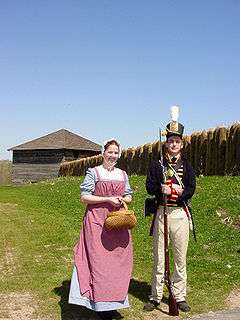
When the war clouds of 1812 began to creep upon Northwest Ohio, General William Henry Harrison ordered the construction of the fort, beginning in February 1813. Harrison was General Anthony Wayne's former aide-de-camp. Later he was elected as the country's ninth president. The installation was named Fort Meigs in honor of Ohio's fourth governor, Return Jonathan Meigs. Fort Meigs was constructed on a bluff above the Maumee River, and built from a design by the army engineer Captain Eleazer D. Wood, for whom the county would be named. Two critical battles with the British were fought at the fort during the War of 1812.
Early settlers in the area fled to Huron during the War of 1812. They returned to settle in the floodplain below Fort Meigs, calling the settlement Orleans. They moved to higher ground after being flooded out. Perrysburg was located by a surveying team led by Alexander Bourne, appointed to that position by Edward Tiffin, Surveyor General of the United States. Contrary to numerous Internet postings, Charles Pierre L'Enfant did NOT survey and plat Perrysburg, Ohio on April 27, 1816; this survey was performed in late June / early July, 1816 by surveyors Joseph Wampler and William Brookfield under the auspices of Alexander Bourne and Josiah Meigs, Surveyor General of Ohio, Michigan, Indiana, Illinois and Missouri.[8]
The town soon became a center for shipbuilding and commerce on Lake Erie. It was named after Commodore Oliver Hazard Perry, naval commander during the War of 1812.[9]
In 1833, Perrysburg contained a court house and jail, a school house, two stores, two taverns, two physicians, two lawyers, about 60 houses, and 250 inhabitants.[10]
In 1854, an epidemic of cholera decimated the population. The town closed down for two months in that summer, trying to contain the epidemic at a time when people did not understand how it was transmitted. More than 100 people died. Other towns along the Maumee also suffered high losses from the epidemic, and Providence, Ohio was abandoned. It has suffered a disastrous fire less than a decade before.
Geography
According to the United States Census Bureau, the city has a total area of 11.51 square miles (29.81 km2), all land.[1]
Demographics
| Historical population | |||
|---|---|---|---|
| Census | Pop. | %± | |
| 1830 | 182 | — | |
| 1840 | 1,041 | 472.0% | |
| 1850 | 1,199 | 15.2% | |
| 1860 | 1,494 | 24.6% | |
| 1870 | 1,835 | 22.8% | |
| 1880 | 1,909 | 4.0% | |
| 1890 | 1,747 | −8.5% | |
| 1900 | 1,766 | 1.1% | |
| 1910 | 1,913 | 8.3% | |
| 1920 | 2,429 | 27.0% | |
| 1930 | 3,182 | 31.0% | |
| 1940 | 3,457 | 8.6% | |
| 1950 | 4,006 | 15.9% | |
| 1960 | 5,519 | 37.8% | |
| 1970 | 7,693 | 39.4% | |
| 1980 | 10,196 | 32.5% | |
| 1990 | 12,551 | 23.1% | |
| 2000 | 16,945 | 35.0% | |
| 2010 | 20,623 | 21.7% | |
| Est. 2015 | 21,423 | [11] | 3.9% |
| Sources:[5][12][13][14][15][16][17][18] | |||
2010 census
As of the census[3] of 2010, there were 20,623 people, 8,246 households, and 5,504 families residing in the city. The population density was 1,791.7 inhabitants per square mile (691.8/km2). There were 8,845 housing units at an average density of 768.5 per square mile (296.7/km2). The racial makeup of the city was 92.9% White, 1.4% African American, 0.1% Native American, 3.1% Asian, 0.8% from other races, and 1.6% from two or more races. Hispanic or Latino of any race were 3.2% of the population.
There were 8,246 households of which 34.7% had children under the age of 18 living with them, 56.5% were married couples living together, 7.3% had a female householder with no husband present, 2.9% had a male householder with no wife present, and 33.3% were non-families. 28.3% of all households were made up of individuals and 11% had someone living alone who was 65 years of age or older. The average household size was 2.48 and the average family size was 3.10.
The median age in the city was 38.4 years. 26.5% of residents were under the age of 18; 6.5% were between the ages of 18 and 24; 27.1% were from 25 to 44; 27.6% were from 45 to 64; and 12.3% were 65 years of age or older. The gender makeup of the city was 48.4% male and 51.6% female.
2000 census
As of the census[5] of 2000, there were 16,945 people, 6,592 households, and 4,561 families residing in the city. The population density was 1,899.2 people per square mile (733.5/km²). There were 6,964 housing units at an average density of 780.5 per square mile (301.4/km²). The racial makeup of the city was 95.34% White, 1.03% African American, 0.10% Native American, 1.77% Asian, 0.02% Pacific Islander, 0.90% from other races, and 0.84% from two or more races. Hispanic or Latino of any race were 2.05% of the population.
There were 6,592 households out of which 38.0% had children under the age of 18 living with them, 61.1% were married couples living together, 6.3% had a female householder with no husband present, and 30.8% were non-families. 27.8% of all households were made up of individuals and 14.2% had someone living alone who was 65 years of age or older. The average household size was 2.55 and the average family size was 3.18.
In the city the population was spread out with 29.0% under the age of 18, 5.6% from 18 to 24, 28.3% from 25 to 44, 24.0% from 45 to 64, and 13.0% who were 65 years of age or older. The median age was 38 years. For every 100 females there were 92.7 males. For every 100 females age 18 and over, there were 86.5 males.
The median income for a household in the city was $62,237 and the median income for a family was $75,651. Males had a median income of $56,496 versus $31,401 for females. The per capita income for the city was $29,652. About 1.5% of families and 2.8% of the population were below the poverty line, including 1.7% of those under age 18 and 8.1% of those age 65 or over.
Education
Perrysburg is home to four elementary schools, one junior high school, Perrysburg High School, and one extracurricular academy. It has received an Excellent rating on the State Report Card for eleven consecutive years[1] and met 26 of 26 of the Ohio Department of Education's indicators with a performance index of 105.6.[19] The district is on the College Board’s AP® District Honor Roll for Significant Gains, has NLL District & Regional Championship teams and performers and has nationally recognized fine and performing arts programs.[20] Over 20 advanced placement and honors classes are offered at Perrysburg High School and the district's elementary schools have robust technology integration.[21] The primary public schools are Fort Meigs, Frank, Toth and Woodland Elementary Schools, with the private Catholic school, Saint Rose, making up the fifth. Perrysburg Junior High School is housed in the old Perrysburg High School building. In addition to property taxes, Perrysburg Schools are supported by 0.5% income tax revenue within the school district.
In the year 2000, 47% of residents of the Perrysburg had a bachelor's degree or a higher level of education as compared to 27.6% of Wood County residents, 25% of residents in the Toledo MSA, 21% of Ohioans and 24% in the U.S.
Library
The Way Public Library serves Perrysburg area. In 2006, the library loaned 521,046 items and provided 539 programs to its 30,161 cardholders. Total holdings in 2006 were nearly 93,000 volumes with over 220 periodical subscriptions.[22]
Notable people

- Burke Badenhop, professional baseball pitcher[23][24]
- Clara Blinn, pioneer who died in the aftermath of the Battle of Washita River.[25]
- Douglas Brinkley, award-winning historian, lived in Perrysburg from 1968 to 1982
- Jerry Glanville, football coach[26]
- Sam Jaeger, actor on Parenthood on NBC[27]
- Jim Leyland, Major League Baseball manager[28]
- Anna Tunnicliffe, 2008 US Olympic Sailing Team gold medalist[29]
- Jim Harbaugh, NFL player and head football coach of the Michigan Wolverines of the University of Michigan
- T. J. Fatinikun, football player
Notable companies
- IMCO Carbide Tool, designer & manufacturer of cutting tools
- Owens-Illinois Inc., glass packaging manufacturer
- Universal Tube & Rollform Equipment, manufacturer and supplier of metal machine tubes and pipe
- FedEx, shipping center
References
- 1 2 "US Gazetteer files 2010". United States Census Bureau. Retrieved 2013-01-06.
- 1 2 "US Board on Geographic Names". United States Geological Survey. 2007-10-25. Retrieved 2008-01-31.
- 1 2 "American FactFinder". United States Census Bureau. Retrieved 2013-01-06.
- ↑ "US Census QuickFacts". United States Census Bureau. Retrieved 2016-06-03.
- 1 2 3 "American FactFinder". United States Census Bureau. Retrieved 2008-01-31.
- ↑ Atlas of Great Lakes Indian History, (University of Oklahoma Press: Norman, 1986) pp. 3, 58–59; and R. Douglas Hurt, The Ohio Frontier: Crucible of the Old Northwest, 1720–1830 (Indiana University Press: Bloomington, 1998), pp. 8–12
- ↑ http://www.remarkableohio.org/HistoricalMarker.aspx?historicalMarkerId=679
- ↑ History of the Maumee River Basin from the Earliest Account to Its Organization into Counties; Charles Elihu Slocum, 1905
- ↑ "Profile for Perrysburg, Ohio". ePodunk. Retrieved 2010-06-06.
- ↑ Kilbourn, John (1833). The Ohio Gazetteer, or, a Topographical Dictionary. Scott and Wright. p. 367. Retrieved 12 December 2013.
- ↑ "Annual Estimates of the Resident Population for Incorporated Places: April 1, 2010 to July 1, 2015". Retrieved July 2, 2016.
- ↑ "Population of Civil Divisions Less than Counties" (PDF). Statistics of the Population of the United States at the Tenth Census. U.S. Census Bureau. Retrieved 28 November 2013.
- ↑ "Population of Civil Divisions Less than Counties" (PDF). Statistics of the Population of the United States at the Tenth Census. U.S. Census Bureau. Retrieved 28 November 2013.
- ↑ "Population: Ohio" (PDF). 1910 U.S. Census. U.S. Census Bureau. Retrieved 28 November 2013.
- ↑ "Population: Ohio" (PDF). 1930 US Census. U.S. Census Bureau. Retrieved 28 November 2013.
- ↑ "Number of Inhabitants: Ohio" (PDF). 18th Census of the United States. U.S. Census Bureau. Retrieved 22 November 2013.
- ↑ "Ohio: Population and Housing Unit Counts" (PDF). U.S. Census Bureau. Retrieved 22 November 2013.
- ↑ "Incorporated Places and Minor Civil Divisions Datasets: Subcounty Population Estimates: April 1, 2010 to July 1, 2012". U.S. Census Bureau. Retrieved 25 November 2013.
- ↑ http://www.ode.state.oh.us/reportcardfiles/2010-2011/DIST/045583.pdf
- ↑ http://www.perrysburgschools.net/district/public/press_releases.php
- ↑ http://www.perrysburgschools.net/district/about/DistrictInfoTriFold.pdf
- ↑ "2006 Ohio Public Library Statistics". State Library of Ohio. Retrieved September 8, 2008.
- ↑ BGSU Falcons player bio. Retrieved on June 13, 2008.
- ↑ Florida Marlins player bio. Retrieved on June 13, 2008.
- ↑ Justus, Judith P. (2000). "The Saga of Clara H. Blinn at the Battle of the Washita." Research Review: Journal of the Little Bighorn Associates 14(1): 11–20, p. 12
- ↑ Portland State U. coach bio. Retrieved on June 13, 2008.
- ↑ IMDB bio. Retrieved on June 13, 2008.
- ↑ Detroit Tigers coach bio. Retrieved on June 13, 2008.
- ↑ The Toledo Blade - Sailing into Olympics. Retrieved on June 13, 2008.
External links
| Wikimedia Commons has media related to Perrysburg, Ohio. |
Municipalities and communities of Wood County, Ohio, United States | ||
|---|---|---|
| Cities | 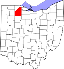 | |
| Villages | ||
| Townships | ||
| CDPs | ||
| Other unincorporated communities | ||
| Footnotes | ‡This populated place also has portions in an adjacent county or counties | |