Monroe, Michigan
| Monroe, Michigan | |
|---|---|
| City | |
|
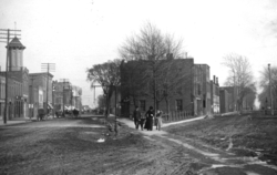
Monroe’s historic downtown on South Monroe Street | |
 Location in Monroe County and the state of Michigan | |
| Coordinates: 41°54′59″N 83°23′52″W / 41.91639°N 83.39778°W | |
| Country | United States |
| State | Michigan |
| County | Monroe |
| Settled | 1785 |
| Platted | 1817 |
| Incorporated | 1837 |
| Government | |
| • Mayor | Robert Clark |
| Area[1] | |
| • City | 10.19 sq mi (26.39 km2) |
| • Land | 9.17 sq mi (23.75 km2) |
| • Water | 1.02 sq mi (2.64 km2) |
| Elevation | 594 ft (182 m) |
| Population (2010)[2] | |
| • City | 20,733 |
| • Estimate (2015[3]) | 20,092 |
| • Density | 2,261.0/sq mi (873.0/km2) |
| • Urban | 51,240 (US: 490th) |
| • Metro | 151,560 (US: 264th) |
| Time zone | Eastern (EST) (UTC-5) |
| • Summer (DST) | EDT (UTC-4) |
| ZIP codes | 48161, 48162 |
| Area code(s) | 734 |
| FIPS code | 26-55020 |
| GNIS feature ID | 0632572[4] |
| Website | http://www.monroemi.gov/ |

Monroe is a city in the U.S. state of Michigan. The population was 20,733 at the 2010 census. It is the largest city and county seat of Monroe County.[5] The city is bordered on the south by Monroe Charter Township, but both are politically independent. The city is located approximately 14 mi (23 km) north of Toledo, Ohio and 25 mi (40 km) south of Detroit. The United States Census Bureau lists Monroe as the core city in the Monroe Metropolitan Area, which had a population of 152,021 in 2010.[6] Monroe is officially part of the Detroit-Ann Arbor-Flint CSA. The city is sometimes unofficially included as a northerly extension of the Toledo Metropolitan Area.
Settled by European Americans in 1784 shortly after the American Revolutionary War, Monroe was platted in 1817.[7] It was named after President James Monroe. Today, the city is committed to historic preservation of resources; it is remembered for the Battle of Frenchtown during the War of 1812, as well as being the childhood residence of George Armstrong Custer and other members of his family, including his brother Boston Custer and wife Elizabeth Bacon. The city has numerous historic museums and landmarks.
Monroe is the home of the La-Z-Boy world headquarters. The population has declined slightly since its peak in 1970.
History
Long occupied by varying cultures of indigenous peoples, the area around the River Raisin was settled by the historic Potawatomi hundreds of years before the French reached the area in the late seventeenth century. Robert de LaSalle claimed the area for New France after his 1679 expedition on the Griffon.
In 1784, after the American Revolutionary War, Francis Navarre of Canada was given a portion of land south of the River Raisin by the Potawatomi. Colonists settled Frenchtown shortly thereafter as the third European community in the state. Around the same time, the Sandy Creek Settlement was established just north of Frenchtown by French-Canadian Joseph Porlier Benec.[8]
Because of its proximity to Detroit, the area was of strategic importance during the War of 1812 between the United States and Great Britain, especially after Detroit surrendered to the British in August 1812. American forces en route to retake Detroit had camped in the area of the River Raisin in the winter of 1812-13. A force of 200 Native Americans and 63 Canadian militia were forced to retreat north away from the River Raisin by 600 Kentucky militiamen and 100 French, under the command of James Winchester, on January 18, 1813. This skirmish was later dubbed the 'First Battle of the River Raisin'.
But, on January 22, a force of 800 Native Americans and 597 British, under Henry Procter (British Army officer), surprised the force of 1,000 Americans and captured Frenchtown. Many of the American militia were inexperienced, ill-trained, and badly equipped. They suffered 397 killed and 547 captured. The British and their allies suffered slight losses.
When the British departed with their captives to Detroit, they left those Americans too wounded to walk in the homes of Frenchtown inhabitants under the guard of a small British detachment and their Native American allies. The morning after the battle, Native Americans returned to Frenchtown. They plundered and burned homes, killing and scalping many of the remaining American captives, and taking others as slaves. The official U.S. estimate of casualties in this aftermath include a dozen named individuals killed and up to 30 more who were likely killed. British estimated six Americans were killed.
This event became known throughout the United States as the 'River Raisin Massacre'. This was also known as the Battle of Frenchtown (or the Second Battle of the River Raisin).[9] Today, the site of the battle is preserved as the recently authorized River Raisin National Battlefield Park.[10] It has a small visitor center.[11]

The area of Frenchtown was renamed after the War of 1812 and incorporated as the village of Monroe in honor of President James Monroe, who visited the Michigan Territory in 1817. In the same year, the city of Monroe was named as the county seat of the newly created Monroe County. Monroe was re-incorporated as a city in 1837.[7]
Settled mostly by American migrants from New York and New England, Monroe also was associated with events in the West in the later 19th century, particularly the Indian Wars. It is known as the childhood home of Major General George Armstrong Custer (1839–1876). His family moved here when he was young, and he lived in Monroe for much of his childhood. Here he later met and in 1864 married Elizabeth Bacon (1842–1933), during the Civil War. He led troops in the Indian Wars and died at the Battle of the Little Bighorn, in which his forces were killed by the Lakota.
In 1910, President William Howard Taft and the widowed Elizabeth Bacon Custer unveiled an equestrian statue of Custer, which now stands at the corner of Elm Street and Monroe Street.[12][13] Custer is also honored in street names, various historic markers, buildings, schools, and the regional Custer Airport.[14] City limit signs for Monroe describe the city as "the home of General Custer."
The famous La-Z-Boy furniture company, known for reclining easy chairs, was founded in Monroe in 1927.[15] Their world headquarters are still located in Monroe, but in a secluded area south of the intersection of La-Z-Boy Blvd and Stewart Rd. This new facility is roughly 1/2 a mile east of its original location on Telegraph Road; the iconic building still exists and is being prepped for potential redevelopment.
In 1974, the Monroe Power Plant opened. In the early 21st century, it is the fourth-largest coal firing plant in North America. At 805 feet (245 m) tall, the dual smokestacks are visible from more than 25 miles (40 km) away and are among the tallest structures in the state.
Demographics
| Historical population | |||
|---|---|---|---|
| Census | Pop. | %± | |
| 1840 | 1,703 | — | |
| 1850 | 2,813 | 65.2% | |
| 1860 | 3,892 | 38.4% | |
| 1870 | 5,086 | 30.7% | |
| 1880 | 4,930 | −3.1% | |
| 1890 | 5,258 | 6.7% | |
| 1900 | 5,043 | −4.1% | |
| 1910 | 6,893 | 36.7% | |
| 1920 | 11,573 | 67.9% | |
| 1930 | 18,110 | 56.5% | |
| 1940 | 18,478 | 2.0% | |
| 1950 | 21,467 | 16.2% | |
| 1960 | 22,968 | 7.0% | |
| 1970 | 23,894 | 4.0% | |
| 1980 | 23,531 | −1.5% | |
| 1990 | 22,625 | −3.9% | |
| 2000 | 22,076 | −2.4% | |
| 2010 | 20,733 | −6.1% | |
| Est. 2015 | 20,092 | [16] | −3.1% |
| U.S. Decennial Census 2011 estimate | |||
2010 census
As of the census[2] of 2010, there were 20,733 people, 8,238 households, and 5,277 families residing in the city. The population density was 2,261.0 inhabitants per square mile (873.0/km2). There were 9,158 housing units at an average density of 998.7 per square mile (385.6/km2). The racial makeup of the city was 88.4% White, 6.2% African American, 0.4% Native American, 0.7% Asian, 1.2% from other races, and 3.0% from two or more races. Hispanic or Latino of any race were 4.1% of the population.
There were 8,238 households of which 34.7% had children under the age of 18 living with them, 41.7% were married couples living together, 17.1% had a female householder with no husband present, 5.3% had a male householder with no wife present, and 35.9% were non-families. 30.6% of all households were made up of individuals and 10.9% had someone living alone who was 65 years of age or older. The average household size was 2.44 and the average family size was 3.05.
The median age in the city was 36.3 years. 26.2% of residents were under the age of 18; 9% were between the ages of 18 and 24; 25.9% were from 25 to 44; 25.4% were from 45 to 64; and 13.3% were 65 years of age or older. The gender makeup of the city was 47.0% male and 53.0% female.
2000 census
In the census of 2000, there were 22,076 people, 8,594 households, and 5,586 families in the city. The population density was 2,440.9 per square mile (942.9/km²). There were 9,107 housing units at an average density of 1,007.0 per square mile (389.0/km²). The racial makeup was 90.87% White, 5.07% African American, 0.24% Native American, 0.84% Asian, 0.02% Pacific Islander, 0.90% from other races, and 2.06% from two or more races. Hispanic or Latino of any race were 2.76% of the population.
There were 8,594 households of which 33.6% had children under 18 living with them, 46.6% were married couples living together, 14.3% had a female householder with no husband present, and 35.0% were non-families. 30.7% of all households were up of individuals and 12.7% had someone living alone 65 years or older. The average household size was 2.47 and the average family size 3.10.
In the city the population was 26.9% under 18, 8.7% from 18 to 24, 29.3% from 25 to 44, 20.1% from 45 to 64, and 15.0% who 65 or older. The median age was 35 years. For every 100 females there were 90.2 males. For every 100 females age 18 and over, there were 85.2 males.
The median income for a household in the city was $41,810, and the median income for a family $51,442. Males had a median income of $42,881 versus $25,816 for females. The per capita income for the city was $19,948. 9.0% of families and 12.6% of the population were below the poverty line, including 15.0% of those under 18 and 16.1% of those 65 or over.
Geography
According to the United States Census Bureau, the city has a total area of 10.19 square miles (26.39 km2), of which 9.17 square miles (23.75 km2) is land and 1.02 square miles (2.64 km2) is water.[1] Monroe sits at the lowest elevation in state of Michigan, which is the shores of Lake Erie at 571 feet (174 meters).[17] The average elevation of the city of Monroe is 594 feet (182 meters).[18] The Port of Monroe is the only Michigan port on Lake Erie,[19] and Sterling State Park is the only of Michigan's 98 state parks located on or near Lake Erie.[20] The River Raisin and Sandy Creek travel through Monroe, although these waterways are unnavigable.
Climate
Monroe lies in the humid continental climate zone. Monroe only receives an average of 28.5 inches (72.4 cm) of snow a year — the lowest average snowfall for any large city in the state. July is the warmest month with an average high temperature of 84 °F (29 °C), and January is the coldest month with an average low temperature of 16 °F (-9 °C). Monroe does not normally have extremely hot or cold temperatures. On average, the temperature only drops below 0 °F (-18 °C) a couple of times during a winter season, and it is even rarer for the temperature to rise above 100 °F (38 °C) during the summer. The coldest recorded temperature was -21 °F (-29 °C) on February 5, 1918. The highest recorded temperature was 106 °F (41 °C) on July 24, 1934, with another equal temperature recorded on one occasion many years earlier.[21]
| Climate data for Monroe, Michigan | |||||||||||||
|---|---|---|---|---|---|---|---|---|---|---|---|---|---|
| Month | Jan | Feb | Mar | Apr | May | Jun | Jul | Aug | Sep | Oct | Nov | Dec | Year |
| Record high °F (°C) | 70 (21) |
70 (21) |
83 (28) |
90 (32) |
95 (35) |
106 (41) |
106 (41) |
103 (39) |
103 (39) |
92 (33) |
81 (27) |
68 (20) |
106 (41) |
| Average high °F (°C) | 31 (−1) |
33 (1) |
43 (6) |
57 (14) |
69 (21) |
80 (27) |
84 (29) |
82 (28) |
75 (24) |
62 (17) |
48 (9) |
36 (2) |
58.3 (14.8) |
| Average low °F (°C) | 16 (−9) |
18 (−8) |
27 (−3) |
38 (3) |
49 (9) |
59 (15) |
64 (18) |
62 (17) |
55 (13) |
43 (6) |
33 (1) |
22 (−6) |
40.5 (4.7) |
| Record low °F (°C) | −18 (−28) |
−21 (−29) |
−2 (−19) |
11 (−12) |
26 (−3) |
35 (2) |
35 (2) |
38 (3) |
27 (−3) |
21 (−6) |
1 (−17) |
−12 (−24) |
−21 (−29) |
| Average precipitation inches (mm) | 1.6 (41) |
1.7 (43) |
2.6 (66) |
3.0 (76) |
3.1 (79) |
3.5 (89) |
3.1 (79) |
3.2 (81) |
3.0 (76) |
2.3 (58) |
2.8 (71) |
2.8 (71) |
32.7 (831) |
| Average snowfall inches (cm) | 7.4 (18.8) |
6.2 (15.7) |
5.3 (13.5) |
0.9 (2.3) |
0 (0) |
0 (0) |
0 (0) |
0 (0) |
0 (0) |
0 (0) |
2.2 (5.6) |
6.0 (15.2) |
28 (71.1) |
| Source: [22] | |||||||||||||
Education

The city of Monroe is served by only one large public school district, Monroe Public Schools (MPS), which enrolls approximately 6,700 students.[23] MPS operates nine elementary schools, one middle school, one high school, one alternative high school, and two specialized education centers.[24] At around 2,100 students, Monroe High School is one of the largest high schools in the state. Monroe is also served by the Monroe County Intermediate School District, which provides services to other schools in the form of special education services, support staff, substitute teachers, and educational technology (such as computers and distance learning). Students in Monroe may also attend one of two public charter schools, and there are also over a dozen various parochial schools in and around Monroe. In 2012, the three largest parochial elementary schools (St. Michael the Archangel, St. Mary and St. John the Baptist) merged to form Monroe Catholic Elementary Schools, serving infants through 8th Grade. The St. Michael Campus hosts infants through 1st grade, while St. John hosts 2nd through 4th grade and St. Mary functions as the Middle School for grades 5 through 8. The largest of the parochial schools is St. Mary Catholic Central High School, which enrolls over 400 students a year and has a full sports program that competes against the other public school districts. Students may also be homeschooled.
Marygrove College, sponsored by the local Sisters, Servants of the Immaculate Heart of Mary (IHM), was founded in Monroe in 1905 as a Catholic, liberal arts college. The college then moved to its current location in Detroit in 1927. The IHM also operated a boarding school, the Hall of the Divine Child, in Monroe from 1918–1980. Monroe County Community College was founded in 1964 just west of Monroe. It is the only higher education school in Monroe County.[25]
Economy
Top employers
According to the City's 2010 Comprehensive Annual Financial Report,[26] the top employers in the city are:
| # | Employer | # of Employees |
|---|---|---|
| 1 | ProMedica Regional Hospital Monroe (formerly Mercy Memorial Hospital) | 1,600 |
| 2 | County of Monroe | 1,062 |
| 3 | DTE Energy | 530 |
| 4 | La-Z-Boy | 522 |
| 5 | Gerdau Macsteel | 450 |
| 6 | Monroe Bank & Trust | 401 |
| 7 | Sisters, Servants of the Immaculate Heart of Mary | 265 |
| 8 | City of Monroe | 205 |
| 9 | Monroe Publishing Company | 200 |
| 10 | SYGMA Network | 162 |
Transportation
The city of Monroe is served by the Lake Erie Transit public transportation bus system. Established in 1975, Lake Erie Transit currently has a fleet of 31 buses and serves approximately 400,000 riders every year. In 2008, the system logged 764,000 miles.[27] The system operates buses on eight fixed routes in and around the city of Monroe. It also serves several neighboring townships outside of its normal routes should a passenger call ahead for a ride. From Bedford Township, its provides transportation to and from two shopping malls in Toledo, Ohio.
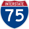 I-75 travels through Monroe and provides access to Toledo and Detroit. There are five interchanges in and near Monroe: LaPlaisance Road (exit 11), Front Street (exit 13), Elm Street (exit 14), North Dixie Highway (exit 15), and Nadeau Road (exit 18).
 I-275 has its southern terminus just north of Monroe. Splitting off from I-75, I-275 is a western bypass around Detroit but does not actually merge back with I-75. Aside from I-75, the highway can be accessed near Monroe by US 24 (Telegraph Road) via exit 2.
 M-50 terminates in Monroe at US 24 and provides a direct route to Dundee, Jackson, and further. In Monroe, M-50 is known locally as South Custer Road. Its former terminus used to be I-75 at exit 15.[28]
 US 24 travels through Monroe and provides access to Toledo and western portions of Detroit. The road is known locally as North Telegraph and South Telegraph — divided at the River Raisin. US 24 also connects to I-275 just north of Monroe.
 M-125 travels directly through the downtown area before merging into US 24 north of Monroe. South of downtown after Jones Avenue, it is called South Dixie Highway. In the downtown area, it is South Monroe Street. North of the River Raisin, it is North Monroe Street.
 M-130 was a state highway existing from 1930 until 1955 and ran along the northern banks of the River Raisin. M-130 had its eastern terminus at US 24 and ran for just over nine miles (14 km). In 1955, control of the highway was transferred back to the county. Today, it is called North Custer Road.
 Dixie Highway ran through Monroe in as early as 1915. It was originally one of the few ways to reach places like Florida, but the highway was largely replaced by I-75 beginning in the 1960s. Today, the namesake of the highway is used for two non-connecting highways (one being M-125), although the same route and remnants of the original highway are long gone.
 US 25 was the designated name for the portion of Dixie Highway north of Cincinnati, including the portion running through Monroe. Like Dixie Highway, US 25 was largely replaced, and the existing highway was truncated at Cincinnati.
 Custer Airport was built in 1946 and is located on the former M-130. It is a very small and seldom used airport. There are no commercial or passenger flights departing from or arriving at Custer Airport. There is one paved runway used by small personal airplanes. There is also a small aviation school on the site. All air services in the area are primarily through the Metro Airport in Wayne County.[14]
Media
Only in Monroe is a monthly public-access television program covering news on the Monroe area. It is hosted by Kaye Lani Rae Rafko and Michelle Bowman. Comedian and nationally known talk show host Stephen Colbert was a guest host of the show on July 1, 2015.[29] Colbert interviewed musician Eminem. "Only in Monroe" and other public access programming can be found on Monroe Public Access Cable Television.
Rewind 94.3 WERW is the low-power educational FM frequency in Monroe, the station at one time belonged to Monroe Public Schools and is currently run by Monroe Public Access Cable Television.
The Monroe News is the daily newspaper in Monroe, reporting on all of Monroe County. The newspaper was founded in 1825 and for many years known as The Monroe Evening News. It was purchased by GateHouse Media in fall 2015, just prior to that The Monroe News had about 20 years of employee ownership.
Monroe County Radio is an Internet radio station founded in fall 2012, the studio is in Monroe with news and sports coverage focusing on Monroe County.
Nash Icon WMIM 98.5 is the Cumulus radio station in the area, the studio is in downtown Monroe. The current music format is country. Prior to Cumulus owning the station, it was locally owned.
Sports
Monroe is the hometown of the Southern Michigan Timberwolves, a semi-professional football team that completes in the Great Lakes Football League. The Timberwolves have won their league championship four times, three in the Mid-Continental Football League (1996, 97 & 99) and the Minor League Football Alliance championship in 2016.[30]
Notable people
- Rance Allen, bishop, songwriter, gospel singer.
- Frankie Biggz (b. Francisco Andres Lucio, 1973), record producer, singer-songwriter, musician, and DJ.
- Vic Braden (1929-2014), tennis champion and coach.
- Christie Brinkley (b. 1954), model, born in Monroe.
- Robert K. Brown (b. 1932), combat correspondent, investigative journalist, and founder, editor, publisher of Soldier of Fortune magazine.
- Horace Thompson Carpenter (1857–1947), artist and art critic, historian.
- Kenny Chesney (b. 1968), country music artist; has relatives in Monroe.
- Isaac P. Christiancy (1812–1890), Chief Justice of the Michigan Supreme Court.
- Ken W. Clawson (1936–1999), Deputy Director of Communications for President Richard Nixon during Watergate scandal.
- Audie Cole (b. 1989), football player for the Minnesota Vikings.
- Oliver H. P. Cowdery (1806–1850), important figure in founding of the Latter Day Saint movement, lived in Monroe.
- Boston Custer (1848–1876), younger brother of General George Custer, lived in Monroe, killed at Battle of Little Big Horn.
- Elizabeth Bacon Custer (1842–1933), wife of General Custer, born in Monroe.
- George Armstrong Custer (1839–1876), soldier, lived much of his early life in Monroe.
- Eric Daman (b. 1970), fashion designer.
- Robert S. Duncanson (1821–1872), first professional African-American artist.
- Elisha Peyre Ferry (1825–1895), first governor of the state of Washington.
- Carl Ford (b. 1980), football player.
- Don Gonyea (b. 1956), White House correspondent for National Public Radio.
- Valerie Harper (b. 1939), actress, star of sitcoms The Mary Tyler Moore Show, Rhoda and Valerie, grew up in Monroe.
- Ernest Ingersoll (1852–1946), environmentalist and naturalist.
- Mary Harris "Mother" Jones (1837–1930), union organizer, lived in Monroe.
- Ernst G. W. Keyl (1804-1872), Lutheran clergyman, died in Monroe.[31]
- Tonya Kinzinger, actress, born in Monroe.
- Karen Koch (b. 1951), world's first professional female ice hockey player.
- Charles Lanman (1819–1895), author, artist and US government official.
- Robert McClelland (1807–1880), prominent Michigan politician.
- Bronco McKart (b. 1971), prizefighter, World Boxing Organization champion.
- J. Sterling Morton (1832–1902), prominent conservationist, lived in Monroe from 1834–1854.
- Roy Parmelee (1907–1981), baseball pitcher in Major Leagues from 1929–1939.
- Kaye Lani Rae Rafko (b. 1963), Miss America 1988.
- Henry Armstrong Reed (1858–1876), nephew of George Custer, lived in Monroe, killed at Little Big Horn.
- James A. Roy, 16th Chief Master Sergeant of the Air Force
- Paul W. Smith, WJR radio personality.
- Vern Sneider (1916–1981), novelist, most famous for Teahouse of the August Moon.
- Matt Urban (1919–1995), most decorated combat soldier of WWII.
- Warner Wing (1805-1876), Michigan jurist and legislator
Sister cities
Monroe, Michigan has only one official sister city:
References
- 1 2 "US Gazetteer files 2010". United States Census Bureau. Retrieved 2012-11-25.
- 1 2 "American FactFinder". United States Census Bureau. Retrieved 2012-11-25.
- ↑ "Population Estimates". United States Census Bureau. Retrieved 2016-06-07.
- ↑ "US Board on Geographic Names". United States Geological Survey. 2007-10-25. Retrieved 2008-01-31.
- ↑ "Find a County". National Association of Counties. Retrieved 2011-06-07.
- ↑ Population of Michigan Regions and Statistical Areas, 2000 and 2010, at www.michigan.gov
- 1 2 Romig, Walter (1986) [1973]. Michigan Place Names. Detroit, Michigan: Wayne State University Press. ISBN 0-8143-1838-X.
- ↑ Monroe, Michigan historical markers
- ↑ "History & Culture". nps.gov.
- ↑ Monroe Evening News staff (31 March 2009). "Battlefield bill signing celebrated". Monroe Evening News. Monroe, Michigan. Retrieved 3 April 2009.
- ↑ Battlefield Visitor Center
- ↑ "History of the Custer statue", New York Times
- ↑ Custer statue moved, Monroe, Michigan Library
- 1 2 http://mich.gov/documents/Ttf_19117_7.pdf Custer Airport details
- ↑ La-Z-Boy history
- ↑ "Annual Estimates of the Resident Population for Incorporated Places: April 1, 2010 to July 1, 2015". Retrieved July 2, 2016.
- ↑ http://egsc.usgs.gov/isb/pubs/booklets/elvadist/elvadist.html#Highest USGS Elevations and Distances in the United States
- ↑ http://michigan.hometownlocator.com/mi/monroe/monroe.cfm Elevation of Monroe, MI
- ↑ http://www.portofmonroe.com/ Port of Monroe
- ↑ http://www.michigandnr.com/ParksandTrails/Details.aspx?id=497&type=SPRK Sterling State Park
- ↑ http://climate.geo.msu.edu/Stations/5558/NARRAT.txt Climate of Monroe
- ↑ "Average Weather for Monroe, MI - Temperature and Precipitation". Weatherbase. Retrieved May 28, 2009.
- ↑ http://www.greatschools.net/michigan/monroe/Monroe-Public-Schools/ Great Schools profile of Monroe Public Schools
- ↑ http://www.monroe.k12.mi.us/ Monroe Public Schools homepage
- ↑ http://www.monroeccc.edu/ MCCC homepage
- ↑ City of Monroe CAFR
- ↑ Michigan DOT: Lake Erie Transit http://www.michigan.gov/mdot/0,1607,7-151-9625_21607-164483--,00.html
- ↑ http://www.michiganhighways.org/listings/MichHwys50-59.html Michigan Highways 50 through 59
- ↑ "Only In Monroe". July 2015. Retrieved July 3, 2015.
- ↑ Monroe Evening News 9/12/2016
- ↑ "Ernst Gerhard Wilhelm Keyl". Retrieved 31 July 2012.
- ↑ http://www.ci.monroe.mi.us/Hofu_Mayor_Visit.cfm Twin towning with Hofu, Japan
External links
| Wikivoyage has a travel guide for Monroe (Michigan). |
- City's official website
- Monroe County Tourism Bureau
- History of Monroe
- Monroe Evening News
- Site Dedicated to Monroe, Michigan
-
 "Monroe, Mich.". Encyclopedia Americana. 1920.
 - "Monroe, a city and county-seat of Monroe co., Mich.". Collier's New Encyclopedia. 1921.
 |
Frenchtown Charter Township | | ||
| Raisinville Township | |
Sterling State Park | ||
| ||||
| | ||||
| Monroe Charter Township | Lake Erie / |
Municipalities and communities of Monroe County, Michigan, United States | ||
|---|---|---|
| Cities | 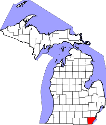 | |
| Villages | ||
| Charter townships | ||
| General law townships | ||
| CDPs | ||
| Other unincorporated communities | ||
| Footnotes | ‡This populated place also has portions in an adjacent county or counties | |
| Topics | 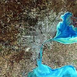 | |
|---|---|---|
| Detroit | ||
| Municipalities over 80,000 | ||
| Municipalities 40,000 to 80,000 | ||
| Cultural enclaves | ||
| Satellite cities | ||
| Counties in MSA | ||
| Counties in CSA | ||
| |
| Founding events | |
| Presidency | |
| Other noted accomplisments | |
| Life | |
| Elections | |
| Legacy and popular culture | |
| Related | |
| Family |
|
| |
Coordinates: 41°54′59″N 83°23′52″W / 41.91639°N 83.39778°W