Twelve Mile Square Reservation
The Twelve Mile Square Reservation, also called the Twelve Mile Square Reserve,[1] was a tract of land in Ohio ceded by Indians to the United States of America in the Treaty of Greenville in 1795. It was subsequently surveyed in a manner different from surrounding land, and lots sold, or granted, to settlers.
History
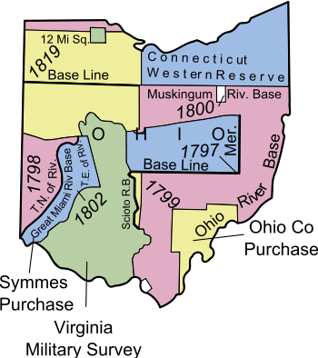
In 1680, Frontenac, the French Governor of Canada, established Fort Miami on the west bank of the Maumee River. It was the first fortification in Ohio built by non-indigenous people. The fort was used as a trading post for a short time, then abandoned. During the Northwest Indian War the British rebuilt Fort Miami to assist the Indians fighting the Americans.[2][3] The Americans won the Battle of Fallen Timbers nearby in 1794. As a result of the battle, the Treaty of Greenville was signed, which ceded much of southern and eastern Ohio to the United States. In addition, Article 3 ceded a number of other tracts, including #8: “One piece twelve miles square, at the British fort on the Miami of the Lake, at the foot of the rapids.”[4] At that time, the Maumee river was called the Miami of the lake, and the foot of the rapids are today between the towns Maumee and Perrysburg. In 1795, Jay’s Treaty led to the fort being abandoned in 1796.
Survey and settlement

While the French and British occupied the region, many white people settled near the fort. The United States wished to give legal title to these people, and sell the rest of the tract.[2] To accomplish this, on March 3, 1805,[5] Congress arranged for a special indiscriminate location survey for the reserve. Deputy surveyor Elias Glover subdivided the tract into four townships of six miles (10 km) square each in 1805, with the southwest township being number one, the northwest number two, the northeast number three, and the southeast number four. The tract has no ranges, and is an original survey, unrelated to later 1821 Congress Lands surveys that surround the reserve, known as North and East of First Principal Meridian.[2][3] Each township was subdivided into 36-square-mile (93 km2) sections numbered boustrophedonically, as established by the Act of May 18, 1796.[6] Under the Act of 1816, Joseph Wampler surveyed the riverfront into long lots of about 160 acres (0.65 km2) each, numbered 1 to 93, and officially called “River Tracts”.[2][3][7] The private claims of the British and French era settlers were surveyed in 1817 by deputy surveyor S. Carpenter.[2] The partial sections left after the River Tracts were called “Fractional Sections”. The Act of 1816 set aside section 16 of each township as School Lands for benefit of schools in each township. These sections were eventually sold. Town lots in Perrysburg were also laid out in 1816, providing less than two sections of land in lots less than ¼ acre each.[3][7] Land sales were through the Wooster Land Office in the Canton Land District.[7]
Modern times
The tract encompasses portions of Wood and Lucas counties, including Perrysburg, Maumee, and south suburban Toledo, Ohio. The corners of the Reservation[8] are at 41°39′13″N 83°45′44″W / 41.65361°N 83.76222°W (NW of the intersection of Dorr and Crissey roads, forming part of the boundary with Spencer and Springfield townships), 41°39′10″N 83°31′33″W / 41.65278°N 83.52583°W (NE of the MLK Bridge within the Maumee River), 41°28′41″N 83°31′45″W / 41.47806°N 83.52917°W (the intersection of Tracy and Dowling roads, forming the SE corner of Perrysburg Township), 41°28′39″N 83°45′43″W / 41.47750°N 83.76194°W (NE of the intersection of Neowash and Noward roads in Waterville Township).
See also
Notes
- ↑ National Mapping Program Technical Instructions: Standards for USGS and USDA Forest Service Single Edition Quadrangle Maps (Draft for Implementation ed.). March 2003. p. 5A-4. Retrieved 2010-07-17
- 1 2 3 4 5 Peters, p. 194-200.
- 1 2 3 4 Knepper, p. 43-45.
- ↑ 7 Stat. 49 - Text of Treaty of Greenville Library of Congress
- ↑ 2 Stat. 343 - Text of Act of March 3, 1805 Library of Congress
- ↑ 1 Stat. 464 - Text of Act of May 18, 1796 Library of Congress
- 1 2 3 3 Stat. 319 - Text of Act of April 27, 1816 Library of Congress
- ↑ corners determined from USGS topographic maps at terraserver
References
- Peters, William E. (1918). Ohio Lands and Their Subdivision. W.E. Peters.
- Knepper, George W. (2002). The Official Ohio Lands Book (PDF). The Auditor of the State of Ohio.
External links
| Six-Mile Rectangular System Surveys |
| |
|---|---|---|
| Five-Mile Rectangular System Surveys | ||
| Indiscriminate Surveys | ||
| metes and bounds Survey | ||
| Land Grants | ||
| Other | ||
Images from Commons | ||