Allerton, Bronx
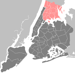
Allerton is a working-class neighborhood geographically located in the East Bronx section of Bronx borough of New York City in the United States. It is named in honor of Daniel Allerton, an early Bronx settler who purchased and farmed this area with his wife Hustace.[1] It consists of both the Bronxwood and Laconia neighborhoods. The neighborhood is part of Bronx Community Board 11. Its boundaries,[2] starting from the north and moving clockwise, are: East Gun Hill Road to the north, IRT Dyre Avenue Line to the east, Waring Avenue south, and Bronx River Parkway to the west. White Plains Road is the primary thoroughfare through Allerton. The local subway is the IRT White Plains Road Line. ZIP codes include 10467. The area is patrolled by the NYPD's 49th Precinct[3] located at 2121 Eastchester Avenue in the Morris Park section of the Bronx.
History
Allerton Avenue was ethnically divided in the 1950s through the 1980s by a distinct separation of Jewish and Italian residents. Primarily a commercial avenue west of Laconia Avenue, the geographic boundary between the Jewish and Italians was Bronxwood Avenue and Boston Post Road. Bordering the largely Jewish Pelham Parkway to the southern extreme of Williamsbridge, the area east of Boston Post Road was predominantly post-war immigrant Italian and to the west an older Jewish community. Mixed in were residents representing earlier 19th and 20th century migrations from Manhattan, largely of Irish and English-Irish extraction. The arrival of West Indians in the 1980s marked the transition, north of Allerton Avenue, from a distinctly Italian area to a West Indian one. West of Bronxwood Avenue, the arrival of Dominicans concurrently marked the end of the Jewish community north of Allerton Avenue (Laconia). Today, the area south of Allerton Avenue and east of Bronxwood Avenue has a large population of Italian-Americans and Albanian-Americans, as well as Asians, Hispanics, West-Indians, and other groups. In February 2014 Google Maps recognized Allerton as the name of a community that had prior been recognized as Williamsbridge or Bronxdale.[4]
Land use and terrain
Allerton is dominated by multi-unit homes of various types. There are also some tenements scattered across the neighborhood, primarily within five blocks of the El on White Plains Road. The total land area is roughly two square miles. The area is low and flat.
Demographics

Based on data from the 2010 United States Census, the population of the combined Allerton-Pelham Gardens neighborhood was 28,903, an increase of 393 (1.4%) from the 28,510 counted in 2000. Covering an area of 726.98 acres (294.20 ha), the neighborhood had a population density of 39.8 inhabitants per acre (25,500/sq mi; 9,800/km2).[5]
The racial makeup of the Allerton-Pelham Gardens neighborhood was 25.3% (7,316) White, 32.5% (9,391) African American, 0.2% (55) Native American, 7.9% (2,282) Asian, 0.0% (12) Pacific Islander, 0.9% (252) from other races, and 1.4% (412) from two or more races. Hispanic or Latino of any race were 31.8% (9,183) of the population.[6]
The neighborhood is now predominantly Hispanic south of Allerton Avenue (Bronxwood) and Black north of Allerton Avenue (Laconia). A smaller longstanding Italian and immigrant Albanian population exist east of White Plains Road primarily in Bronxwood near Esplanade Avenue. The majority of residents rent. Under 20% of the population lives below the poverty line in Bronxwood while over 20% of the population lives below the poverty line in Laconia.[7]
Public housing
Four NYCHA developments are located in Allerton.[8]
- Boston Road Plaza; one, 20-story building
- Eastchester Gardens; ten buildings, 7 and 8-stories tall
- Parkside Houses; 14 buildings, 6, 7, 14 and 15-stories tall
- Pelham Parkway Houses; twenty-three, 6-story buildings
Subsections
- Bronxwood is the southern part of Allerton. It has a population over 20,000. Its boundaries, starting from the north and moving clockwise are: Allerton Avenue to the north, Esplanade Avenue to the east, Pelham Parkway to the south, and the Bronx River Parkway to the west. Bronxwood includes the Pelham Parkway Houses and Boston Road Plaza.
- Laconia is the northern part of Allerton. It has a population under 25,000. Its boundaries, starting from the north and moving clockwise are: East Gun Hill Road to the north, the IRT Dyre Avenue Line to the east, Allerton Avenue to the south, and Bronxwood Avenue to the west. Laconia includes the Eastchester Houses.
- Olinville is the northwestern part of Allerton; it is also considered part of Williamsbridge. Residences include the Parkside Housing Projects. Its boundaries, starting from the north and moving clockwise are; East Gun Hill Road to the north, Bronxwood Avenue to the east, Allerton Avenue to the south, and the Bronx River Parkway to the west.
Schools
- PS 41: Gun Hill Road (Olinville Av. and Rosewood St.)
- PS 76: Bennington (Adee and Bronxwood Aves.)
- PS 96: Richard Rodgers (Waring and Barker Aves.)
- PS 89: Williamsbridge Middle School (Mace Ave. and Williamsbridge Road)
- IS 322: Aspire Preparatory (Mace and Wallace Aves.)
- IS 326: Bronx Green Middle School (Mace and Wallace Aves.)
- IS 468: Pelham Academy of Academics and Community Engagement (Mace and Wallace Aves.)
- Christopher Columbus High School (920 Astor Ave.)
Transportation
- Bx8: to 225th Street station or Locust Point (via Williamsbridge Rd)
- Bx26: to Lehman College or Co-op City (via Allerton Av)
- Bx28-Bx38: to Co-op City or Fordham (via Gun Hill Road)
- Bx39: to Wakefield – 241st Street station or Clason's Point (via White Plains Rd)
- Bee-Line 60: to White Plains
- Bee-Line 61: to Port Chester
- Bee-Line 62 Limited: to White Plains
- Gun Hill Road (IRT White Plains Road Line) (2 5)
- Gun Hill Road (IRT Dyre Avenue Line) (5)
- Burke Avenue (2 5)
- Allerton Avenue (2 5)
References
| Wikimedia Commons has media related to Allerton, Bronx. |
- ↑ Bronx Neighborhood Fights for Its Spot on the Map
- ↑ "Living in Allerton, the Bronx". The New York Times. Retrieved 24 October 2015.
- ↑ "49th Precinct". Retrieved 24 October 2015.
- ↑ Hu, Winnie (April 6, 2014). "Bronx Neighborhood Fights for Its Spot on the Map". New York Times. Retrieved April 30, 2014.
- ↑ Table PL-P5 NTA: Total Population and Persons Per Acre - New York City Neighborhood Tabulation Areas*, 2010, Population Division - New York City Department of City Planning, February 2012. Accessed June 16, 2016.
- ↑ Table PL-P3A NTA: Total Population by Mutually Exclusive Race and Hispanic Origin - New York City Neighborhood Tabulation Areas*, 2010, Population Division - New York City Department of City Planning, March 29, 2011. Accessed June 14, 2016.
- ↑ Bronx Community District 11
- ↑ NYCHA
Coordinates: 40°51′56″N 73°51′39″W / 40.86556°N 73.86083°W