Wakefield, Bronx
| Wakefield | |
|---|---|
| Neighborhood of The Bronx | |
 Wakefield  Wakefield  Wakefield Location in New York City | |
| Coordinates: 40°53′52″N 73°51′08″W / 40.897877°N 73.852357°WCoordinates: 40°53′52″N 73°51′08″W / 40.897877°N 73.852357°W | |
| Country |
|
| State |
|
| City |
|
| Borough |
|
| Area[1] | |
| • Total | 2.57 km2 (0.991 sq mi) |
| Population (2011)[1] | |
| • Total | 29,158 |
| • Density | 11,000/km2 (29,000/sq mi) |
| Economics | |
| • Median income | $56,446 |
| ZIP codes | 10466, 10470 |
| Area code | 718, 347, 646 |
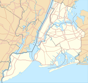
Wakefield is a working-class and middle-class section of the northern borough of the Bronx in New York City, bounded by the New York city line with Westchester County or 243rd street to the north, 222nd Street to the south, and the Bronx River, Bronx River Parkway and Metro-North Railroad tracks to the west. Wakefield is the northernmost neighborhood in New York City (although the city's northernmost point is actually in Riverdale, at the College of Mount Saint Vincent). The neighborhood is part of Bronx Community Board 12.[2] The neighborhood's primary ZIP Code is 10466, with certain areas around East 241st Street and White Plains Road listed as 10470.
History

Wakefield, like the rest of the Bronx, was once mainly forested and later became farmland. With the expansion of railroad transportation via the arrival of the New York and Harlem Railroad circa 1840, the area experienced moderate development before the borough was merged with New York County as a result of the state legislature's decision to amalgamate the four original boroughs to form New York City. Prior to this merger, Wakefield and the Bronx were politically part of Westchester County (the Bronx later attained independent county status on April 19, 1912, which makes it the 62nd and youngest county in the state). The current Wakefield station of the Metro-North Railroad's Harlem Line was on the site of a village called Washingtonville, which was incorporated into Wakefield when it became a village on August 8, 1889.[3][4]
Demographics
Formerly, Wakefield was home to large Irish American and Italian-American populations. During the 1980s, these communities were replaced with large African American populations, which now comprise 72.3% of the neighborhood's total population. 19.6% of the population is Hispanic [5] Many residents are or are descended from Jamaican and West Indian immigrants.[6]
The 2000 United States Census reported a total of 68,787 residents. Wakefield was named after the Virginia plantation where George Washington was born.[7]
Education
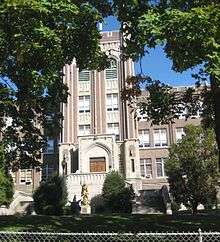
The neighborhood is home to the prominent all-male Catholic secondary school Mount Saint Michael Academy, which serves 1,100 students from grades 7-12. The all-female St. Barnabas High School is located further west in Woodlawn and serves many students from Wakefield itself.
Social problems
Though the crime rate has historically been high, like other sections of New York, Wakefield has shown a steep decline in both violent and non-violent crime.[8] The neighborhood has also seen a rise in gangs and gang-related violence from neighboring Edenwald[9] The high school drop-out rate is higher than the city average, but lower than central Bronx neighborhoods.[10] Many households in the area are headed by a single mother.[11]
Transportation
- Bx8: to Locust Point (via Williamsbridge Road)
- Bx16: to Eastchester or Norwood – 205th Street (via Nereid Avenue and Mundy Lane)
- Bx31: to Woodlawn or Westchester Square (via Eastchester Road)
- Bx39: to Soundview and Clasons Point, Bronx (via White Plains Road)
- BxM11: express bus to Midtown Manhattan
- Wakefield – 241st Street (IRT White Plains Road Line) (2 5 trains)
- Nereid Avenue (IRT White Plains Road Line) (2 5 trains)
- 233rd Street (IRT White Plains Road Line) (2 5 trains)
- 225th Street (IRT White Plains Road Line) (2 5 trains)
- Wakefield (Metro-North station) (Harlem Line)
In popular culture
Several scenes from the 1970 film Love Story starring Ryan O'Neal and Ali MacGraw were filmed on East 233rd Street, East 238th Street (Nereid Avenue), and Barnes Avenue, all located within the neighborhood. The Redeemer Evangelical Lutheran Church located at 4360 Barnes Avenue (corner of Boyd Avenue) is featured in the film.
Notable natives and residents
- Lloyd Barnes - Jamaican music producer[12]
- Darcel Clark - Present Bronx District Attorney[13]
- Desus – comedian and TV personality[14]
- Adelina Patti - 19th century opera singer[15]
- Harry G. Pellegrin - musician and author[16]
- Cristina Santiago - LGBT activist, was one of seven victims killed during the August 2011 Indiana State Fair stage collapse (1981–2011)[17]
- AJ Silver (born Angelo Iodice) - American rodeo circuit celebrity [18]
References
- 1 2 "Wakefield neighborhood in New York". Retrieved 22 October 2015.
- ↑ "Bronx Community District 12" (PDF). Retrieved 22 October 2015.
- ↑ https://books.google.ca/books?id=nqslAQAAIAAJ&pg=PR9&lpg=PR9&dq=1888+boundaries+%22Village+of+Far+Rockaway%22&source=bl&ots=Mdn023p5Hi&sig=MlBl1mUy2c_beiH_RYErWvuzHW4&hl=en&sa=X&ved=0ahUKEwipmN6C5YzOAhUPwWMKHTa5B-gQ6AEIJjAC#v=onepage&q=1888%20boundaries%20%22Village%20of%20Far%20Rockaway%22&f=false
- ↑ "If You're Thinking of Living In / Wakefield, the Bronx; Hugging Westchester At the Subway's End". The New York Times. Retrieved 22 October 2015.
- ↑ U.S. Census Bureau
- ↑ Brown, Kristen V. (February 13, 2008). "City Living: Wakefield, Bronx". amNewYork. Retrieved 2009-08-21.
- ↑ Cohen, Joyce (January 31, 1999). "If You're Thinking of Living In / Wakefield, the Bronx; Hugging Westchester At the Subway's End". The New York Times. Retrieved 2009-08-21.
- ↑ 47th Precinct Comp Stat Report, August 2008
- ↑ Parker, Billy (April 29, 2009). "Major Bloods Arrests Remind Us: NYC Still Terrifying". Gothamist. Retrieved 2009-08-21.
- ↑ Losen, Daniel J. (March 20, 2006). "Behind the Dropout Rate". Gotham Gazette. Retrieved 2009-08-21.
- ↑ Bronx Census Data Analysis
- ↑ Koppel, Niko (April 12, 2009). "New Roots in the Bronx for a Lion of Reggae". The New York Times. Retrieved 2009-06-17.
- ↑ Likely Bronx DA Has Plans from The Wall Street Journal 27 October 2015
- ↑ How Desus and Kid Mero Went From Twitter Cranks to Comedy's Hottest Duo
- ↑ Bronx County Clerk's Office
- ↑ Government Conspiracy to Remove Potential Social Security Recipients From Baby Boomer Generation 17 April 2004
- ↑ Wake To Be Held For Christina Santiago, Bronx Native Killed In Stage Collapse At Indiana State Fair from CBS News 18 August 2011
- ↑ Bronx Buckaroo AJ Silver is the real Urban Cowboy from New York Daily News, 4 April 2014.
- "City Living: Wakefield, Bronx". Newsday. 2008-02-13. Retrieved 2015-11-12.
External links
| Wikimedia Commons has media related to Wakefield, Bronx. |
- Wakefield Branch of the New York Public Library
- Wakefield from Forgotten NY