Ohio State Route 252
| ||||
|---|---|---|---|---|
 | ||||
| Route information | ||||
| Maintained by ODOT | ||||
| Length: | 23.04 mi[1][2][3] (37.08 km) | |||
| Existed: | 1925[4][5] – present | |||
| Major junctions | ||||
| South end: |
| |||
|
| ||||
| North end: |
| |||
| Location | ||||
| Counties: | Medina, Lorain, Cuyahoga | |||
| Highway system | ||||
| ||||

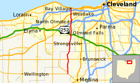
State Route 252 (SR 252) is a 23.04-mile (37.08 km) long north–south state highway in the northern portion of the U.S. state of Ohio. The southern terminus of this state route is at a signalized intersection that marks the western split of the concurrency of SR 18 and SR 57 nearly 1.25 miles (2.01 km) northwest of the city limits of Medina. SR 252 has its northern terminus at a T-intersection with U.S. Route 6 (US 6) in the western Cleveland suburb of Bay Village.
Route description
Along its path, SR 252 travels through northern Medina County, the extreme eastern portion of Lorain County and the westernmost part of Cuyahoga County. There are no stretches of SR 252 that are included as a part of the National Highway System.[6]
History
SR 252 was assigned in 1925. It was originally along its current alignment from its southern terminus at SR 18 and SR 57 northwest of Medina to its junction with SR 82, at the time known as SR 81, west of Strongsville.[4][5] One year later, the highway was extended north to its current northern terminus.[7]
Major intersections
| County | Location | mi[1][2][3] | km | Destinations | Notes |
|---|---|---|---|---|---|
| Medina | York Township | 0.00 | 0.00 | Southern terminus of SR 252 and concurrency with SR 57 | |
| 0.93 | 1.50 | Northern terminus of concurrency with SR 57 | |||
| Liverpool Township | 4.92 | 7.92 | |||
| Lorain | Columbia Township | 10.45 | 16.82 | ||
| Cuyahoga | North Olmsted | 17.68 | 28.45 | Exit 6 on I-480 | |
| 18.01 | 28.98 | ||||
| 18.45 | 29.69 | Southern terminus of concurrency with SR 10 | |||
| 18.84 | 30.32 | Northern terminus of concurrency with SR 10 | |||
| Westlake | 21.01 | 33.81 | |||
| 21.99 | 35.39 | ||||
| 22.13 | 35.61 | Exit 159 on I-90 / SR 2 | |||
| Bay Village | 23.04 | 37.08 | Northern terminus | ||
1.000 mi = 1.609 km; 1.000 km = 0.621 mi
| |||||
References
- 1 2 Ohio Department of Transportation. "Technical Services Straight Line Diagrams: SR 252, Medina County" (PDF). Retrieved 2011-05-09.
- 1 2 Ohio Department of Transportation. "Technical Services Straight Line Diagrams: SR 252, Lorain County" (PDF). Retrieved 2011-05-09.
- 1 2 Ohio Department of Transportation. "Technical Services Straight Line Diagrams: SR 252, Cuyahoga County" (PDF). Retrieved 2011-05-09.
- 1 2 Map of Ohio Showing State Routes (MrSID) (Map). Cartography by ODHPW. Ohio Department of Highways and Public Works. August 1924. Retrieved 2011-05-10.
- 1 2 Map of Ohio Showing State Routes (MrSID) (Map). Cartography by ODHPW. Ohio Department of Highways and Public Works. August 1925. Retrieved 2011-05-10.
- ↑ National Highway System: Ohio (PDF) (Map). Federal Highway Administration. December 2003. Retrieved 2011-05-09.
- ↑ Map of Ohio Showing State Routes (MrSID) (Map). Cartography by ODHPW. Ohio Department of Highways and Public Works. August 1926. Retrieved 2011-05-10.