Ohio State Route 2
| |||||||
|---|---|---|---|---|---|---|---|
|
Route of SR 2 highlighted in red | |||||||
| Route information | |||||||
| Maintained by ODOT | |||||||
| Length: | 227.26 mi[1] (365.74 km) | ||||||
| Existed: | 1912[2] – present | ||||||
| Major junctions | |||||||
| West end: |
| ||||||
| East end: |
| ||||||
| Location | |||||||
| Counties: | Defiance, Williams, Fulton, Lucas, Ottawa, Erie, Lorain, Cuyahoga, Lake | ||||||
| Highway system | |||||||
| |||||||

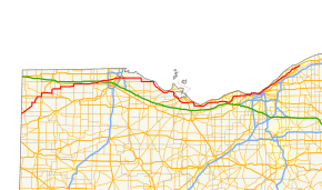
State Route 2 (SR 2), formerly known as Inter-county Highway 2 until 1921[3] and State Highway 2 in 1922,[4] is an east–west highway crossing most of northern Ohio. Its western terminus is at the Indiana state line near Hicksville where the route becomes Indiana State Road 37 which continues to Fort Wayne, Indiana. The eastern terminus of the route is in Painesville Township in Lake County at U.S. Route 20 (US 20).
Route description
It passes through Bryan, Wauseon (where it briefly becomes a couplet[5]), and enters greater Toledo west of its interchange with the Ohio Turnpike. It continues east from greater Toledo and soon parallels Lake Erie, becoming a freeway near Port Clinton. From Oregon to Sandusky SR 2 is part of 293 miles (472 km) of the highway designated the "Lake Erie Coastal Ohio Trail".[6] and on September 22, 2005 was designated a National Scenic Byway[7] From Toledo to Sandusky the highway is also part of and designated the Lake Erie Circle Tour that is also part of the 6,500-mile (10,500 km) "Great Lakes Circle.[8] It then passes Sandusky, where it meets U.S. Route 250 and U.S. Route 6, and separates from the lakeshore as a freeway, and traverses rural Erie County before entering Lorain County. Near Elyria, it joins Interstate 90, whose route it shares to Rocky River, where it follows State Route 254 along Detroit Road into Lakewood. Here it again joins U.S. 6, as well as U.S. Route 20 on Clifton Blvd. It then becomes part of the Cleveland Memorial Shoreway in Cleveland, joining I-90 again near Burke Lakefront Airport. These two highways split near Euclid, and State Route 2 continues along the Lakeland Freeway to Painesville, feeding into U.S. 20 eastbound. State Route 2 serves as an access route to lakeshore attractions on Lake Erie from Toledo and Cleveland and as an alternative to the Ohio Turnpike.
The stretch of SR 2 from Toledo to Sandusky passes several attractions. The Ottawa National Wildlife Refuge is just east of SR 19 in Carroll Township. It sits on 733 acres (297 ha) along with the Davis-Besse Nuclear Power Station.
SR 2 is the lowest numbered state route in Ohio. Ohio State Route 1 was decommissioned in 1965.
Naming
The section of State Route 2 that runs through Erie County is called the "Jackie Mayer Miss America Highway" and is named for Jackie Mayer, a former Miss America who was born and raised in Sandusky.[9]
The section of State Route 2 that runs through Willoughby is named "Brian Montgomery Memorial Highway"[10] in honor of a Marine Lance Corporal that was killed in the Iraq War in August 2005.[11]

.png)
History
- 1912: Intercounty Highway 2 runs from Cleveland to the Pennsylvania state line.[12]
- 1923: Route is extended to follow current US 6 alignment from the Indiana state line to Bryan, and current SR 51 and US 20 from Toledo to the Pennsylvania state line.[13]
- 1926–1927: Rerouted from Toledo to Cleveland along previous SR 23 alignment from Toledo to Port Clinton, previously unnumbered route from Port Clinton to 2 miles (3.2 km) west of Sandusky, and previous SR 12 from 2 miles (3.2 km) west of Sandusky to Cleveland. Cleveland-to-Pennsylvania alignment certified as US 20.[13]
- 1931: Extended east to Willoughby along previously unnumbered route (St. Clair).
- 1931–1932: Western terminus shortened to Bryan, Bryan to Indiana state line certified as US 6
- 1936: Extended to Indiana state line via the former SR 108 alignment from Hicksville to Bryan, and the former SR 18 alignment from the Indiana state line to Hicksville, with which it was dually certified along this route until 1940.[13]
- 1939: SR 18 alignment removed from SR 2 alignment west of Hicksville.[13]
- 1939: Route extended east to Lost Nation Road in Willoughby.
- 1941: SR 2 from West 6th to East 9th moved from Lakeside Avenue to the Lakefront Highway, later called the Cleveland Memorial Shoreway. Lakeside certified as SR 2 temporary.
- 1962: Extended east to SR 283 in Painesville; Euclid-to-Painesville alignment upgraded to freeway.[13]
- 1967: 9 miles (14 km) west of Sandusky to 4 miles (6.4 km) west of Sandusky upgraded to freeway, and rerouted on the bypass around Sandusky on former US 6 alignment.[13]
- 1967: Route extended to its current eastern terminus at US 20 in Perry
- 1968: From SR 163 to 9 miles (14 km) west of Sandusky upgraded to freeway.[13]
- 1970: From 2 miles (3.2 km) west of Amherst to SR 83 (SR 76 at that time) upgraded to freeway; from 4 miles (6.4 km) east of Amherst to SR 83 dually certified with I-90.[13]
- 1973–1975: OH 2 Alt is deleted as discontinuous sections of Route 2 are moved from US 6 to I-90.
- 1976: From Ceylon to 2 miles (3.2 km) west of Amherst upgraded to freeway.[13]
- 1977: From SR 83 to Rocky River upgraded to freeway and dually certified with I-90.[13]
- August 30, 1990: From Huron to Ceylon upgraded to freeway.[14]
Major intersections
| County | Location | mi[1] | km | Exit[15] | Destinations | Notes |
|---|---|---|---|---|---|---|
| Defiance | Hicksville Township | 0.00 | 0.00 | Indiana state line; SR 37 continues to the southwest | ||
| Hicksville | 2.35 | 3.78 | Southern end of SR 49 concurrency | |||
| 2.66 | 4.28 | Southern end of SR 18 concurrency | ||||
| 3.07 | 4.94 | Northern end of SR 18 concurrency | ||||
| 3.67 | 5.91 | Northern end of SR 49 concurrency | ||||
| Farmer Township | 11.22 | 18.06 | Western end of SR 249 concurrency | |||
| 13.23 | 21.29 | Eastern end of SR 249 concurrency | ||||
| Williams | Center Township | 16.65 | 26.80 | Southern terminus of SR 576 | ||
| 17.92 | 28.84 | Western end of US 6 concurrency | ||||
| Pulaski Township | 20.35 | 32.75 | Eastern end of US 6 concurrency; southern end of US 127/SR 15 concurrency | |||
| Bryan | 21.39 | 34.42 | Northern end of US 127/SR 15 concurrency; western end of SR 34 concurrency | |||
| Springfield Township | 29.90 | 48.12 | Eastern end of SR 34 concurrency; southern end of SR 191 concurrency | |||
| Stryker | 31.78 | 51.14 | Northern end of SR 191 concurrency | |||
| Fulton | Archbold | 38.03 | 61.20 | Southern end of SR 66 concurrency | ||
| German Township | 39.64 | 63.79 | Northern end of SR 66 concurrency | |||
| Wauseon | SR 2D east | Western terminus of SR 2D; eastbound unsigned | ||||
| 48.82 | 78.57 | Southern end of SR 108 concurrency | ||||
| Eastern terminus of SR 2D; signed as SR 2 westbound | ||||||
| 50.42 | 81.14 | Northern end of SR 108 concurrency; western end of US 20A concurrency | ||||
| York Township | 55.44 | 89.22 | Western end of SR 109 concurrency | |||
| Delta | 57.22 | 92.09 | Eastern end of SR 109 concurrency | |||
| Swanton | 63.42 | 102.06 | Western end of SR 64 concurrency | |||
| Lucas | Swanton Township | 64.14 | 103.22 | Eastern end of SR 64 concurrency | ||
| 65.89 | 106.04 | Eastern end of US 20A concurrency; western end of SR 295 concurrency | ||||
| 66.68 | 107.31 | Eastern end of SR 295 concurrency | ||||
| Monclova Township | 67.60 | 108.79 | Exit 52 on I-80/I-90/Ohio Tpk. | |||
| Springfield Township | 73.92 | 118.96 | Exit 8 on I-475/US 23 | |||
| Toledo | 75.37 | 121.30 | ||||
| 79.39 | 127.77 | |||||
| 80.95 | 130.28 | Anthony Wayne Trail, former US 25 | ||||
| 82.26 | 132.38 | Western end of SR 51/SR 65 concurrency | ||||
| 82.62 | 132.96 | Anthony Wayne Bridge over Maumee River | ||||
| 83.06 | 133.67 | Eastern end of SR 65 concurrency | ||||
| 83.51 | 134.40 | Eastern end of SR 51 concurrency | ||||
| Oregon | 84.90 | 136.63 | Western end of LECT concurrency; exit 7 on I-280 | |||
| Ottawa | Benton Township | 99.30 | 159.81 | Eastern terminus of SR 579 | ||
| 101.06 | 162.64 | Northern terminus of SR 590 | ||||
| Carroll Township | 105.01 | 169.00 | Northern terminus of SR 19 | |||
| Erie Township | 114.21 | 183.80 | Northern terminus of SR 358 | |||
| Rest Area (at grade intersection) | ||||||
| Western end of freeway section | ||||||
| 115.49 | 185.86 | 115 | Eastbound entrance and westbound exit | |||
| Bay Township | 117.54 | 189.16 | 117 | Western end of SR 53 concurrency | ||
| Portage Township | 121.33 | 195.26 | 121 | Double trumpet interchange; signed as 121A (west) and 121B (east); via unsigned SR 2C | ||
| 123.74 | 199.14 | 124 | Eastern end of SR 53 concurrency | |||
| Danbury Township | 124.82 | 200.88 | 125A | Northern end of SR 269 concurrency; double trumpet interchange | ||
| 125B | Bay Shore Road | Double trumpet interchange | ||||
| Sandusky Bay | 126.45 | 203.50 | Thomas A. Edison Memorial Bridge | |||
| Erie | Margaretta Township | 128.34 | 206.54 | — | Southern end of SR 269 concurrency | |
| Sandusky | 130.75 | 210.42 | — | Eastern terminus of LECT concurrency | ||
| Margaretta Township | 132.70 | 213.56 | — | Eastern terminus of SR 101 | ||
| Perkins Township | 134.58 | 216.59 | — | |||
| 138.45 | 222.81 | — | ||||
| Huron | 141.87 | 228.32 | — | Western end of US 6 concurrency | ||
| 142.84 | 229.88 | — | Eastern end of US 6 concurrency; eastbound exit and westbound entrance | |||
| Huron Township | 144.76 | 232.97 | — | |||
| Berlin Township | 147.14 | 236.80 | — | Berlin Road | ||
| 148.67 | 239.26 | 148 | Exit numbered only on westbound side | |||
| Vermilion Township | 156.02 | 251.09 | 156 | |||
| Lorain | Brownhelm Township | 157.27– 157.65 | 253.10– 253.71 | Lorain Service Plaza / Rest Area | ||
| Vermillion | 158.39 | 254.90 | 158 | Vermilion Road / Sunnyside Road | Exit numbered only on eastbound side | |
| 160.21 | 257.83 | 160 | ||||
| Amherst | 162.73 | 261.89 | 163 | North Lake Street / Oak Point Road | ||
| 164.43 | 264.62 | 164 | ||||
| Lorain | 166.55 | 268.04 | 166 | Middle Ridge Road / Broadway Avenue | ||
| Elyria Township | 168.15 | 270.61 | — | Western end of I-90 concurrency; westbound exit and eastbound entrance; I-90 exit 144 | ||
| Elyria | 169.39 | 272.61 | 145 | Exit numbers follow I-90 west of the turnpike | ||
| Sheffield | 171.84 | 276.55 | 148 | |||
| Avon | 175.01 | 281.65 | 151 | |||
| 176.74 | 284.44 | 153 | ||||
| 155 | Nagel Road | |||||
| Cuyahoga | Westlake | 156 | Crocker Road / Bassett Road | |||
| 183.08 | 294.64 | 159 | ||||
| 160 | Clague Road | Westbound exit, eastbound entrance | ||||
| Rocky River | 185.29 | 298.20 | Eastern end of I-90 concurrency; western end of SR 254 concurrency; no access to I-90 eastbound from SR 2 westbound | |||
| Eastern end of freeway section | ||||||
| 186.63 | 300.35 | Eastern end of SR 254 concurrency | ||||
| 186.95 | 300.87 | — | Interchange; western end of US 6 and LECT concurrency; westbound left exit and eastbound left entrance | |||
| Lakewood | 187.81 | 302.25 | Western end of US 20 concurrency; northern terminus of SR 237 | |||
| Cleveland | Western end of freeway | |||||
| 191 | Lake Avenue / West Boulevard | Westbound exit and eastbound entrance | ||||
| — | West 73rd Street | Access to West 73rd Street opened December 12, 2015;[16] exit formerly known as Edgewater Park, Whiskey Island | ||||
| 193.54 | 311.47 | — | West 45th Street | Eastbound exit and entrance; ramps being rebuilt[17] | ||
| 193 | West 49th Street | Westbound exit and entrance | ||||
| 193.86 | 311.99 | 193B | (West 25th Street) | Eastern end of US 6/US 20 concurrency; to SR 3 (unsigned); eastbound exit and westbound entrance; eastbound entrance in planning stages[18] | ||
| 193.8 | 311.9 | 194 | West 28th Street – Flats West | Westbound exit and eastbound entrance; entrance to be closed to reroute entrance trafic via 45th. [19] | ||
| 193.80– 195.14 | 311.89– 314.05 | Main Avenue Bridge over the Cuyahoga River | ||||
| 194.65 | 313.26 | 194 | Lakeside Avenue / West 6th Street | Eastbound exit and westbound entrance | ||
| 194.65 | 313.26 | 195B | West 3rd Street | Westbound exit and eastbound entrance | ||
| 195.31 | 314.32 | 195A | East 9th Street – Rock and Roll Hall of Fame | |||
| City of Cleveland Parking | Eastbound entrance; former exit removed after 1979[20] | |||||
| 195B | City of Cleveland Parking | Eastbound exit and entrance, first exit | ||||
| 195A | City of Cleveland Parking – Amtrak Station | Eastbound exit and entrance, second exit | ||||
| 196B | Eastbound exit | |||||
| 196.17 | 315.71 | 196 | South Marginal Road | Westbound exit and entrance | ||
| 196.61 | 316.41 | — | Western end of I-90 westbound concurrency; westbound exit from I-90 via exit 174B; eastbound and westbound entrance via eastbound I-90 from the Innerbelt | |||
| 196C | South Marginal Road | Eastbound exit, exit follows SR 2 numbering | ||||
| Western end of eastbound concurrency with I-90 | ||||||
| 175 | East 55th Street / Marginal Roads | Exit numbers west of Dead Man's Curve follow I-90 | ||||
| 176 | Western end of SR 283 concurrency | |||||
| 177 | Martin Luther King Jr. Boulevard | |||||
| Bratenahl | 178 | Eddy Road | ||||
| 202.30 | 325.57 | 179 | Eastern end of SR 283 and LECT concurrencies; eastbound exit and westbound entrance | |||
| Cleveland | 180 | East 140th Street / East 152nd Street | Signed as exits 180A (East 140th Street) and 180B (East 152nd Street) eastbound | |||
| 181 | East 156th Street | Westbound entrance and exit | ||||
| 182A | East 185th Street | |||||
| 182B | East 200th Street | |||||
| Euclid | 183 | East 222nd Street | ||||
| 184 | Signed as exit 184B eastbound; Babbitt Rd. not signed eastbound | |||||
| 207.79 | 334.41 | 207 | Left exit westbound; exit numbers follow SR 2 in Lake County; eastern end of I-90 concurrency; exit 185 on I-90 westbound | |||
| Lake | Wickliffe | 208.74 | 335.93 | 208 | Lloyd Road (SR 633) – Wickliffe | Access via Lakeland Boulevard |
| 210.21 | 338.30 | 210 | East 305th Street – Willowick | |||
| Eastlake | 211.62 | 340.57 | 211 | |||
| Willoughby | 212.40 | 341.82 | 212 | |||
| 213.82 | 344.11 | 213 | Lost Nation Road | |||
| Mentor | 215.34 | 346.56 | 215 | |||
| 217.95 | 350.76 | 217 | ||||
| 221.02 | 355.70 | 220 | Western end of SR 44 concurrency | |||
| Painesville Township | 221.94 | 357.18 | 221 | Eastern end of SR 44 concurrency | ||
| Painesville | 223.16 | 359.14 | 223 | |||
| Painesville Township | 225.92 | 363.58 | 225 | Eastbound exit and westbound entrance | ||
| 227.26 | 365.74 | 227 | Eastern terminus | |||
1.000 mi = 1.609 km; 1.000 km = 0.621 mi
| ||||||
Auxiliary routes
SR 2 Temporary
| |
|---|---|
| Location: | Cleveland |
| Existed: | 1941–1967 |
- State Route 2 temporary was a designation that ran from West 6th to East 9th along Lakeside ave. in downtown Cleveland. The designation was added when the final alignments of SR 2 were moved to the then new Lakeside Highway, later referred to as the Cleveland Memorial Shoreway. The route's eastern terminus was moved to public square via Ontario St. in 1957.
SR 2C
| State Route 2C | |
|---|---|
| Location: | Port Clinton |
| Existed: | 1967–present |
- State Route 2C is an unsigned connecting road that runs from State Route 163 to State Route 2 and State Route 53 near Port Clinton in Ottawa County, Ohio. State Route 2C was constructed as an access road for the SR 2–SR 163 interchange.[21]
SR 2D
| |
|---|---|
| Location: | Wauseon |
| Existed: | 1972–present |
- State Route 2D is part of a couplet in Wauseon, Ohio that is signed as State Route 2.[5][22] SR 2D is signed as SR 2 westbound,[22][23] while SR 2 is signed as SR 2 eastbound,[24] (except west of East Elm Street, where SR 2D meets SR 2 at its western terminus[25]). The route ends at the corner of East Linfoot Street and North Shoop Avenue.[22]
Cultural references
In the 2014 film Captain America: The Winter Soldier, the Cleveland Memorial Shoreway is used to depict a freeway in Washington, D.C.[26]
Gallery
-
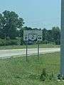
Wide variant of State Route 2 signage at US 6 in Bryan
-

SR 2 in Bryan
-

SR 2 in Farmer
-
US 20A / SR 2 in Delta
-
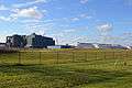
US 20A / SR 2 along the North Star BlueScope Steel mill located southwest of Delta
-
.JPG)
US 127 / SR 2 / SR 15 in Bryan
-

Cleveland Memorial Shoreway in 2013
-
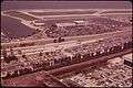
Cleveland Memorial Shoreway in 1973 (Former parking lot exit pictured)

References
- 1 2 Mileages retrieved from Technical Services Straight Line Diagrams unless otherwise noted.
- ↑ Ohio State Highway Department (1912). Highway Map of Ohio (MrSID) (Map). Columbus: Ohio State Highway Department. OCLC 13716556.
- ↑ Ohio Department of Highways and Public Works (September 1921). Highway Map of Ohio (Map). Columbus: Ohio Department of Highways and Public Works.
- ↑ Ohio Department of Highways and Public Works (April 1922). Map of Ohio State Highways (MrSID) (Map). Columbus: Ohio Department of Highways and Public Works.
- 1 2 Ohio Department of Transportation. "Technical Services Straight Line Diagrams: SR 2D, Fulton County" (PDF). Retrieved October 12, 2013.
- ↑ "Lake Erie Ohio Coastal Trail".
- ↑ "National Scenic Byway".
- ↑ "Great Lakes Circle".
- ↑ Ohio Revised Code 5533.66
- ↑ Ohio Revised Code 5533.63.2
- ↑ "Willoughby Family Mourns Loss of Marine Son". Cleveland: WEWS-TV. August 3, 2005. Archived from the original on November 5, 2005. Retrieved November 11, 2015.
- ↑ "Pages: Official Transportation Maps". Ohio Department of Transportation.
- 1 2 3 4 5 6 7 8 9 10 Simpson, John. "Route 2". The Unofficial Ohio State Highways Web Site. Archived from the original on February 5, 2005.
- ↑ Thoma, Pauline (August 31, 1990). "Celeste opens Huron Bypass". The Plain Dealer. Cleveland. Retrieved October 7, 2012. (subscription required (help)).
- ↑
- Kitsko, Jeffrey J. (June 18, 2004). "OH 2 Exit Guide". Ohio Highways. Archived from the original on June 18, 2004. Retrieved January 8, 2016.
- Kitsko, Jeffrey J. (June 17, 2004). "Interstate 90 Exit Guide". Ohio Highways. Archived from the original on June 17, 2004. Retrieved January 8, 2016.
- Fannin, Marc; Gorte, Brandon M.; Slater, C.C. "Ohio 2 East". The Western Reserve Exit Guide Page. Archived from the original on March 4, 2016. Retrieved May 20, 2016.
- Fannin, Marc; Gorte, Brandon M.; Slater, C.C. "Ohio 2/Cleveland Memorial Shoreway West". The Western Reserve Exit Guide Page. Archived from the original on March 6, 2016. Retrieved May 20, 2016.
- ↑ Ohio Department of Transportation District 12 (December 12, 2015). "West 73rd St Extension Opens link to Lake Erie on Cleveland's West Side" (Press release). Ohio Department of Transportation. Retrieved December 16, 2015.
- ↑ http://www.dot.state.oh.us/projects/ClevelandUrbanCoreProjects/LakefrontWest/ProjectGroups/Pages/WestShorewayW28thW45thStreets.aspx
- ↑ http://www.dot.state.oh.us/projects/ClevelandUrbanCoreProjects/LakefrontWest/ProjectGroups/Pages/WestShorewayW28thW45thStreets.aspx
- ↑ http://www.dot.state.oh.us/projects/ClevelandUrbanCoreProjects/LakefrontWest/ProjectGroups/Pages/WestShorewayW28thW45thStreets.aspx
- ↑ "Cleveland Historical Maps (1979)". peoplemaps.esri. Retrieved March 18, 2016.
- ↑ Ohio Department of Transportation Technical Services Straight Line Diagram for SR 2C
- 1 2 3 Google (October 28, 2015). "Eastern Terminus of SR 2D" (Map). Google Maps. Google. Retrieved October 28, 2015.
- ↑
- Google (October 28, 2015). "Eastern Terminus of SR 2D, Facing south" (Map). Google Maps. Google. Retrieved October 28, 2015.
- Google (October 28, 2015). "First Westbound Sign" (Map). Google Maps. Google. Retrieved October 28, 2015.
- Google (October 28, 2015). "Second Westbound Sign" (Map). Google Maps. Google. Retrieved October 28, 2015.
- Google (October 28, 2015). "Third Westbound Sign" (Map). Google Maps. Google. Retrieved October 28, 2015.
- Google (October 28, 2015). "Fourth Westbound Sign" (Map). Google Maps. Google. Retrieved October 28, 2015.
- Google (October 28, 2015). "Fifth Westbound Sign" (Map). Google Maps. Google. Retrieved October 28, 2015.
- Google (October 28, 2015). "Eastbound JCT with Westbound SR 2" (Map). Google Maps. Google. Retrieved October 28, 2015.
- ↑
- Google (October 28, 2015). "First Eastbound Sign" (Map). Google Maps. Google. Retrieved October 28, 2015.
- Google (October 28, 2015). "Second Eastbound Sign" (Map). Google Maps. Google. Retrieved October 28, 2015.
- Google (October 28, 2015). "Third Eastbound Sign" (Map). Google Maps. Google. Retrieved October 28, 2015.
- Google (October 28, 2015). "Fourth Eastbound Sign" (Map). Google Maps. Google. Retrieved October 28, 2015.
- Google (October 28, 2015). "Fifth Eastbound Sign" (Map). Google Maps. Google. Retrieved October 28, 2015.
- Google (October 28, 2015). "Sixth Eastbound Sign" (Map). Google Maps. Google. Retrieved October 28, 2015.
- Google (October 28, 2015). "Seventh Eastbound Sign" (Map). Google Maps. Google. Retrieved October 28, 2015.
- Google (October 28, 2015). "Westbound JCT with Westbound SR 2" (Map). Google Maps. Google. Retrieved October 28, 2015.
- ↑ Google (October 28, 2015). "Western Terminus of SR 2D" (Map). Google Maps. Google. Retrieved October 28, 2015.
- ↑ O'Connor, Clint (March 28, 2014). "Cleveland Is All Over 'Captain America: The Winter Soldier'". The Plain Dealer. Cleveland. Retrieved August 28, 2016.
External links
 Media related to Ohio State Route 2 at Wikimedia Commons