Nyang River

The Nyang River (Tibetan: ཉང་ཆུ, Wylie: nyang chu ; Chinese: 尼洋曲; also transliterated as Niyang or Nanpan) is a major river in south-west Tibet and the longest tributary of the Yarlung Tsangpo River.
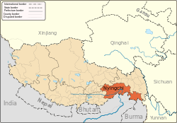
The Nyang has a length of 307.5 km and originates at 5,000 meters above the sea level from the Cuomuliangla in the Goikarla Rigyu, west of the Mila Mountain. The river joins the Yarlung Tsangpo in Cemeng, Nyingchi, 2,580 meters below its source.[1] With an average flow of 538 cubic meters per second, it has an aquatic power potential of 2.08 million kilowatts. Its largest tributary is the Ba River. It flows past the town of Bayi where it is crossed by the Bayi Zanchen bridge.[2]
According to a Chinese government website aimed at investors,[3] the Nyang River valley has an area of 24,800 km², including 175,700 mǔ (117 km²) of cultivated land, 209,800 mǔ (140 km²) of usable wasteland, 24.75 million mǔ (16,500 km²) of forestry land, and 12 million mǔ (8,000 km²) of usable grassland. It is also reported to contain 1,500 kinds of wild animals and plants, 310,000,000 million m³ of wood reserves and 18 million kw of hydroenergy resources.
See also
Footnotes
- ↑ Nyang river information published on www.tibet.cn, visited August 4, 2007.
- ↑ Dorje (1999), p. 236.
- ↑ Comprehensive Development of Agriculture in Niyang River Valley, Beijing Office of the People's Government of Tibet Autonomous Region, visited August 4, 2007
References
- Dorje, Gyume. (1999). Footprint Tibet Handbook with Bhutan. 2nd Edition. Footprint Handbooks, Bath, England. ISBN 1-900949-33-4.
Coordinates: 29°26′01″N 94°29′04″E / 29.4337°N 94.4844°E