Huangpu River
| Huangpu River (黄浦江) | |
| Pu Jiang (浦江) Chunshen Jiang (春申江) Shen Jiang (申江) | |
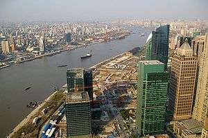 A view of the Huangpu River as it flows through downtown Shanghai. | |
| Country | China |
|---|---|
| Municipality | Shanghai |
| Tributaries | |
| - left | Suzhou Creek |
| Source | Dianshan Lake |
| - location | Zhujiajiao, Qingpu, Shanghai, China |
| Mouth | Yangtze River |
| Length | 113 km (70 mi) |
| Discharge | |
| - average | 180 m3/s (6,357 cu ft/s) [1] |
| Huangpu River | |||||||||||||
| Simplified Chinese | 黄浦江 | ||||||||||||
|---|---|---|---|---|---|---|---|---|---|---|---|---|---|
| Traditional Chinese | 黃浦江 | ||||||||||||
| Postal | Whangpoo River | ||||||||||||
| Literal meaning | Yellow Bank River | ||||||||||||
| |||||||||||||
The ![]() Huangpu , formerly romanized as Whangpoo,[n 1] is a 113-kilometer (70 mi) long river flowing through Shanghai that was first excavated and created by Lord Chunshen, one of the Four Lords of the Warring States during the Warring States period (475 BC - 221 BC). It is the last significant tributary of the Yangtze before it empties into the East China Sea. The Bund and Lujiazui are located along the river.
Huangpu , formerly romanized as Whangpoo,[n 1] is a 113-kilometer (70 mi) long river flowing through Shanghai that was first excavated and created by Lord Chunshen, one of the Four Lords of the Warring States during the Warring States period (475 BC - 221 BC). It is the last significant tributary of the Yangtze before it empties into the East China Sea. The Bund and Lujiazui are located along the river.
The Huangpu is the largest river in Shanghai, with Suzhou Creek being its major tributary. It is on average 400 meters wide and 9 meters deep. It divides the city into two regions: Pudong ("East Bank") and Puxi ("West Bank").[3]

Bridges
- Songpu Bridge
- Xupu Bridge
- Lupu Bridge
- Nanpu Bridge
- Yangpu Bridge
Tunnels
Many lines of the Shanghai Metro cross underneath the river.There are also many tunnels crossing under the river.
Ferries
There are currently several ferry lines operated by Shanghai Ferry.
Controversy
In March 2013, thousands of pig carcasses were found floating in the Huangpu River in Shanghai.[4] Some of the pigs carried ear tags saying they were from Jiaxing, so that city in Zhejiang may be the source; however local farmers deny that.[5]
See also
| Wikimedia Commons has media related to Huangpu River. |
Notes
References
Citations
- ↑ (四)水文 (Chinese)
- ↑ Sladen (1895), p. 278.
- ↑ "The New Huangpu River Both Banks". Retrieved Apr 16, 2014.
- ↑ Hook, Leslie (May 14, 2013). "China: High and dry: Water shortages put a brake on economic growth". Financial Times. Retrieved 2013-05-15.
- ↑ Barboza, David (March 14, 2013). "A Tide of Death, but This Time Food Supply Is Safe". New York Times.
Bibliography
- Sladen, Douglas (1895), "Bits of China", The Japs at Home, 5th ed., New York: New Amsterdam Book Co., pp. 276–354.
Coordinates: 31°23′19.72″N 121°30′55.12″E / 31.3888111°N 121.5153111°E