Nanpan River
Not to be confused with the Nyang River in Tibet, also known as the Nanpan River.
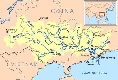
The Pearl River system with the Nanpan River in the west
The Nanpan River (Chinese: 南盘江; pinyin: Nánpánjiāng) has its source in the Yungui Plateau of eastern Yunnan Province. It then flows east, forming part of the border between Guizhou and Guangxi provinces. It joins with the Beipan River to become the Hongshui River.
Part of the Nanpan River is blocked by the Tianshengqiao Dam (Chinese: 天生桥大坝; pinyin: Tiānshēngqiáo dà bà), from which Wanfeng Lake (Chinese: 万峰湖; pinyin: Wànfēng hú) is formed.
Coordinates: 24°57′16″N 106°8′30″E / 24.95444°N 106.14167°EAlong the Nanpan river, many ports were owned by the Cen clan who established in Guangxi to suppress a rebellion since 1053 AD.[1]
References
- ↑ The Nanpan River: A Scenic Waterway in Southeast China, by Qin Nina. February 2015. China Scenic Magazine. Online. The article includes historical information about the Cen clan. The article states, "These ancient ports [of Nanpan River] were once all under the jurisdiction of the Cen clan of Guangxi. The Cen clan was the most powerful and influential Tusi in Guangxi since the Northern Song Dynasty (960–1127 AD). Their ancestors had traveled to the region with Di Qing (1008–1057AD), a famous general of the Northern Song, to suppress a rebellion there. Since 1053 AD, when Cen Zhongshu was appointed to remain in Guangxi as an official, the Cen clan’s influence in the area began to grow and the Nanpan River basin was one of the most important areas under their control".
This article is issued from Wikipedia - version of the 4/29/2016. The text is available under the Creative Commons Attribution/Share Alike but additional terms may apply for the media files.