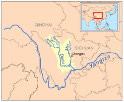
Min River (Sichuan)
| Min River | |
|---|---|
| Country | China |
| Basin | |
| Main source | Songpan |
| River mouth | Chang Jiang at Yibin |
| Features | |
| Tributaries |
|
The Min River or Min Jiang (Chinese: 岷江, p Mínjiāng) is a 735-kilometer-long river (457 mi) in central Sichuan province, China. It is a tributary of the upper Yangtze River which it joins at Yibin. Within China, it was traditionally taken as the main course of the upper Yangtze prior to extensive exploration of its sources.[1][2]
Geography
The Min River flows in the general southern direction. It starts in north-central Sichuan, where its basin is limited by the Qionglai Mountains in the west and the Min Mountains in the east. The river passes through the Longmen Range and enters the plains of the Sichuan Basin near Dujiangyan City; in that area, the ancient Dujiangyan Irrigation System (都江堰) and the modern Zipingpu dam are located. The Giant Buddha of Leshan is built into the stone banks of the Min.
Names
Some 19th-century Western authors used the name Blue River as the "colloquial name" for the Minjiang, after the former local Chinese name Qingshui (清水, lit. "Clear Water").[3] and the belief that the Min constituted the main course of the Yangtze,[1] which was itself known to Europeans as the "Blue River".[4]
Wildlife
A survey by biologist Deng Qixiang found that only 16 of the 40 fish species recorded in the 1950s are to be found today. The Sichuan Taimen, a protected species, has not been seen in one stretch of river, the Wenchuan, for an entire decade.[5]
History
Located along the Min River is the oldest surviving water management scheme built by hydraulic engineer Li Bing, helping to greatly expand the power of the Qin state, and triggering a population boom in the Chengdu plain. It was built about 2,300 years ago. The first western academic to research its history was Joseph Needham. It is named the Dujiangyan Irrigation System.
Dams
The Min is being heavily developed, primarily for hydroelectric power. A total of 27 dams are completed, under construction or planned for the river, as of March 2014. Those dams are listed below from downstream to upstream.[6][7]
- Pianchuangzi Dam – Completed, 740 MW
- Longxikou Dam – Planned, 360 MW
- Jianwei Dam – Planned, 360 MW
- Shazui Dam – Planned, 250 MW
- Banqiaoxi Dam – Planned, 30 MW
- Yangliuhu Dam – Planned, 76.5 MW
- Zipingpu Dam – Completed, 760 MW
- Yingxiuwan Dam – Completed, 135 MW
- Taipingyi Dam – Completed, 260 MW
- Futangba Dam – Completed, 360 MW
- Shaba Dam – Under construction, 720 MW
- Jiangsheba Dam – Completed, 96 MW
- Yangmaoping Dam – Planned, 3.4 MW
- Tongzhong Dam – Completed, 49.5 MW
- Nanxin Dam – Completed, 9.6 MW
- Shigu Dam – Completed, 2.7 MW
- Zongqu Dam – Planned, 2 MW
- Yaneryan Dam – Planned, 66 MW
- Feihongqiao Dam – Planned, 120 MW
- Jinlongtan Dam – Completed, 180 MW
- Tianlonghu Dam – Completed, 180 MW
- Xiaohaizi Dam – Completed, 48 MW
- Lianhuayan Dam – Planned, 111 MW
- Wulibao Dam – Planned, 157 MW
- Longpan Dam – Planned, 72.6 MW
- Xiningguan Dam – Planned, 37.2 MW
- Hongqiaoguan Dam – Planned, 68.5 MW
See also
Notes
- 1 2 Jamieson, George. Encyclopædia Britannica, 11th ed. "Yangtsze-Kiang". Cambridge Univ. Press, 1911. Accessed 14 August 2013.
- ↑ Fan Chengda. James M. Hargett (trans.) Riding the River Home: A Complete and Annotated Translation of Fan Chengda's (1126–1193) Travel Diary Record of a Boat Trip to Wu, p. 77. Chinese Univ. of Hong Kong (Hong Kong), 2008. Accessed 15 August 2013.
- ↑ Davenport, Arthur (1877), Report upon the trading capabilities of the country traversed by the Yunnan Mission, Harrison and Sons, pp. 10–11
- ↑ E.g., Moll, Herman. "The Empire of China and island of Japan, agreeable to modern history." Bowles & Bowles (London), 1736. Accessed 13 August 2013.
- ↑
- ↑ Dong, Luan. "INTERACTIVE: Mapping China's "Dam Rush"". Wilson Center. Retrieved 15 June 2014.
- ↑ "The Last Report on China's Rivers". China's Rivers Report. March 2014. Retrieved 15 June 2014.
Coordinates: 28°46′14″N 104°37′56″E / 28.77056°N 104.63222°E
Sichuan topics | |||||||
|---|---|---|---|---|---|---|---|
| General | |||||||
| History |
| ||||||
| Geography | |||||||
| Culture |
| ||||||
| People | |||||||
| Languages |
| ||||||
| Visitor attractions | |||||||