Red River (Asia)
| Sông Hồng | |
| Sông Thao, Hồng Hà, Nhị Hà, Nhĩ Hà, sông Cái, Nguyên Giang | |
| Sông | |
 | |
| Countries | China, Vietnam |
|---|---|
| Provinces | Yunnan, Lào Cai Province, Yên Bái Province, Phú Thọ Province, Hanoi, Vĩnh Phúc Province, Hưng Yên Province, Hà Nam Province, Thái Bình Province, Nam Định Province |
| Tributaries | |
| - left | Lô |
| - right | Đà |
| Source | |
| - location | Hengduan Mountains, Weishan, Dali, Yunnan, China |
| - elevation | 1,776 m (5,827 ft) |
| Secondary source | |
| - location | TBD, Xiangyun, Dali, Yunnan, China |
| Source confluence | |
| - elevation | 1,200 m (3,937 ft) |
| - coordinates | 25°1′49″N 100°48′56″E / 25.03028°N 100.81556°E |
| Mouth | Ba Lạt |
| - location | (boundary between Tiền Hải and Giao Thủy) |
| - elevation | 0 m (0 ft) |
| - coordinates | 20°14′43″N 106°35′20″E / 20.24528°N 106.58889°ECoordinates: 20°14′43″N 106°35′20″E / 20.24528°N 106.58889°E |
| Length | 1,149 km (714 mi) |
| Basin | 143,700 km2 (55,483 sq mi) |
| Discharge | mouth |
| - average | 2,640 m3/s (93,231 cu ft/s) |
| - max | 30,000 m3/s (1,059,440 cu ft/s) |
| - min | 700 m3/s (24,720 cu ft/s) |
| Discharge elsewhere (average) | |
| - Việt Trì | 900 m3/s (31,783 cu ft/s) |
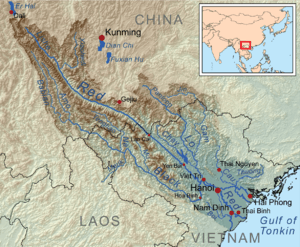 Red River and its tributaries. | |

The Red River (Chinese: t 紅河, s 红河, p Hóng Hé; Vietnamese: Sông Hồng), also known as the Hồng Hà and Sông Cái (lit. "Mother River") in Vietnamese and the Yuan River (元江, Yuán Jiāng) in Chinese, is a river that flows from Yunnan in southwest China through northern Vietnam to the Gulf of Tonkin. According to C. Michael Hogan, the associated Red River Fault was instrumental in forming the entire South China Sea at least as early as 37 million years before present.
Geography
The Red River begins in China's Yunnan province in the mountains south of Dali. It flows generally southeastward, passing through Dai ethnic minority areas before leaving China through Yunnan's Honghe Autonomous Prefecture. It enters Vietnam at Lào Cai Province. It forms a portion of the international border between China and Vietnam. The river, known as Thao River for this upper stretch, continues its southeasterly course through northwestern Vietnam before emerging from the mountains to reach the midlands. Its main tributaries, the Black River (Da River) and Lô River join in to form the very broad Hồng near Việt Trì, Phu Tho Province. Downstream from Việt Trì, the river and its many distributaries spread out to form the Red River Delta. The Red River flows past the Vietnamese capital Hanoi before emptying into the Gulf of Tonkin.
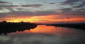
The reddish-brown heavily silt-laden water gives the river its name. The red river has a reddish-brown tint to the river because of the silt. The Red River is notorious for its violent floods with its seasonally wide volume fluctuations. The delta is a major agricultural area of Vietnam with vast area devoted to rice. The land is protected by an elaborate network of dikes and levees.
The Black River and Lô River are the Red River's two chief tributaries.
As a travel and transportation route
In the 19th century, the Red River was thought to be a lucrative trade route to China. The late 19th-century French explorers were able to travel up the Red River until Manhao in South Yunnan, and then overland toward Kunming.[1]
The Red River remained the main commercial travel route between the French Indochina and Yunnan until the opening of the Kunming–Hai Phong Railway in 1910. Thanks to the river, Hai Phong was in the early 20th century the sea port most easily accessible from Kunming. Still, the travel time between Hai Phong and Kunming was reckoned by the Western authorities at 28 days: it involved 16 days of travel by steamer and then a small boat up the Red River to Manhao (425 miles), and then 12 days overland (194 miles) to Kunming.[2]
Settlements
China
Vietnam
- Hà Nội
- Hà Nam Province
- Hưng Yên Province
- Lào Cai Province
- Nam Định Province
- Phú Thọ Province
- Cẩm Khê District (old name: Sông Thao District)
- Hạ Hòa
- Lâm Thao
- Phú Thọ
- Tam Nông
- Thanh Ba
- Thanh Thủy
- Việt Trì
- Thái Bình Province
- Vĩnh Phúc Province
- Yên Bái Province
See also
References
- C. Michael Hogan (2011) South China Sea Topic ed. P.Saundry. Ed.-in-chief C.J.Cleveland. Encyclopedia of Earth. National Council for Science and the Environment. Washington DC
- earthtrends.wri.org, Water Resources eAtlas, Hong (Red River)
- ↑ Bulletin of the Geographical Society of Philadelphia, 9–10, Geographical Society, 1912, pp. 18–20
- ↑ Whates, H. (1901), The Politician's Handbook, Vacher & Sons, p. 146
External links
![]() Media related to Red River (Asia) at Wikimedia Commons
Media related to Red River (Asia) at Wikimedia Commons
- song ma- Song Ma tinh Son La
| Historical sites Public buildings and places |  | |
|---|---|---|
| Religious and worship sites | ||
| Parks and green areas | ||
| Museums | ||
| Occupational villages | ||
| Other constructions | ||
Yunnan topics | |
|---|---|
| General | |
| Geography | |
| Education | |
| Culture | |
| Cuisine |
|
| Visitor attractions | |
| |