Yongding River
- For the Yongding River in Fujian, see Ting River (of which that Yongding River is a tributary)
The Yongding River (simplified Chinese: 永定河; traditional Chinese: same; pinyin: Yǒngdìng Hé; Wade Giles: Yungting River) is a river in northern China. It is one of the main tributaries in the Hai River system and is best known as the largest river to flow through Beijing Municipality.
Geography

The Yongding River is 650 kilometres (400 mi) in length and drains an area of 47,016 square kilometres (18,153 sq mi). It emerges from the Guancen Mountains (管涔山) in Ningwu County, Shanxi Province, where it is known as the Cangqian River (桑乾河) and flows northeast into Inner Mongolia and then heads southeast into Hebei Province.
In Huailai County, it fills the Guanting Reservoir, the biggest reservoir serving Beijing and takes on the name Yongding. It enters Beijing Municipality through the Xishan Mountains west of the city in Mentougou District and descends into the flatlands of Fengtai and Daxing Districts.
The river eventually flows back into Hebei Province and then on to Tianjin Municipality, where it meets the Hai River just before the latter enters the city and then empties into the Bohai Sea at Tanggu. Part of the river is diverted before the juncture with the Hai, and flows directly into the Bohai Sea. This channel is called the Yongding New River (永定新河).

History
Historically, the river was notorious for its flash floods and course changes. The river has taken at least three major courses through Beijing. According to the earliest historical records, the river originally flowed northeast from Babaoshan toward what is now the Purple Bamboo Park in Haidian District and into Wenyu River.
- Western Han Dynasty
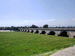
In the Western Han Dynasty, the river flowed south from Deshengmen through the present-day downtown Beijing, including Qianmen and Hongqiao and Longtan Lake, before leaving to the southeast. At that time, the city was situated to the southwest of today's city centre. In the Liao Dynasty, the river moved southwest to its present course, and the Lugou Bridge was built over it in 1189. When Marco Polo visited the city during the Yuan Dynasty, he crossed the Yongding River on the Lugou Bridge, which became known as the Marco Polo Bridge.

- Qing Dynasty
The river has been known colloquially as the Wuding River or the "River of Instability." In 1698, the Qing Dynasty Kangxi Emperor's government reinforced the river banks and rendered the current course permanent. Thereafter it became known as the Yongding River or the "River of Eternal Stability."[1]
References
| Wikimedia Commons has media related to Yongding River. |
- ↑ Li, Lillian M. (2007). Fighting Famine in North China: State, Market, and Environmental Decline, 1690s-1990s. Stanford University Press. pp. 41–43. ISBN 0-8047-5304-0.
Coordinates: 39°09′44″N 117°10′34″E / 39.1623°N 117.1762°E