North Carolina Highway 211
| ||||
|---|---|---|---|---|
|
Route of NC 211 highlighted in red | ||||
| Route information | ||||
| Maintained by NCDOT | ||||
| Length: | 162.5 mi[1] (261.5 km) | |||
| Existed: | 1921 – present | |||
| Major junctions | ||||
| South end: |
| |||
|
| ||||
| West end: |
| |||
| Location | ||||
| Counties: | Brunswick, Columbus, Bladen, Robeson, Hoke, Moore, Montgomery | |||
| Highway system | ||||
| ||||

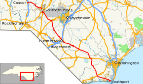
North Carolina Highway 211 (NC 211) is a primary state highway in the U.S. state of North Carolina. It traverses mostly through the Sandhills and Coastal Plain regions of the state; connecting the cities of Candor, Aberdeen, Raeford, Lumberton, Bladenboro, and Southport.
Route description
NC 211 is predominantly a two-lane rural highway that traverses for 158.4 miles (254.9 km) in a diagonal northwesterly route. Its southern terminus is at US 421, via the Fort Fisher Ferry Terminal, in Fort Fisher. Crossing the Cape Fear River on the Fisher-Southport Ferry, travelers enter the town of Southport; where the highway first goes through the downtown area before begins its northwesterly direction to Supply, where it connects with US 17.
Now going on an almost due north direction, it passes through the Green Swamp Preserve, reaching the town of Bolton, where it connects with US 74 and US 76. This section of highway may one day be paralleled by a future segment of I-74.
Returning to a north-westerly direction, it goes through Clarkton (connecting with US 701) and makes a bypass north of Bladenboro before reaching the biggest city along its route, Lumberton. In Lumberton, it follows Roberts Avenue, as it bypasses the downtown area; at the north-end of Lumberton, it connects with I-95/US 301.
North of Red Springs, the highway designations change from north–south to east–west direction; though it continues to go on an almost northerly route through Raeford (connecting with US 401), passing along the western edge of Fort Bragg, and Aberdeen (connecting with US 1/US 15/US 501), until it reaches a roundabout in Pinehurst. After the roundabout, NC 211 goes on a more westerly direction, it traverses through West End and Eagle Springs, before ending at its western terminus in Candor (connecting with I-73/I-74/US 220).
History
Established in 1921 as an original state highway, traversing from NC 23 (today US 701 Bus), in Clarkton, to NC 20 (today NC 72), in Lumberton. In 1930, it was extended south as a new primary routing to US 17/NC 20 (today NC 214), in Bolton. In 1932, it extended north as a new primary routing to NC 70 (today NC 72), in Red Springs. By 1935, its northern terminus was extended again to Aberdeen, replacing NC 70. In 1940, its third northern extension was made, overlapping with US 15/US 501 through Aberdeen, then replacing NC 2 to its current terminus in Candor.
In the late 1940s, NC 211's route was realigned from Main Street to South Street, in Aberdeen; some of the former routing became part of NC 5. During the early 1950s, NC 211 made a fourth extension north in Candor, replacing US 220 on Pack House Road; this lasted until June, 1963 where it was moved back to its former and current northern terminus.[2]
In the mid-1950s, NC 211 made the following adjustments: at Eagle Springs, it was placed on new construction bypassing north of the community, its old alignment becoming Eagle Springs Road (SR 1138). In Bolton, it was removed from Old 211 (SR 1805) and extended south on new primary routing to US 17/NC 130, in Supply. And in Lumberton, it was moved onto its current alignment on Roberts Avenue, its old alignment becoming NC 211A (later becoming NC 211 Business).
In 1957, NC 211 was extended south, overlapping with NC 130, into Southport (at Moore Street). Between 1958-1962, various alignment changes were made along the route at Antioch and Seven Lakes. Also around 1961, NC 211 was rerouted with US 15/US 501 between Aberdeen and Pinehurst to the roundabout, then onto new primary routing that avoided central Pinehurst; the old alignment became part of NC 5. In 1969, NC 211 was placed on new routing west of the McCain community, leaving Old NC 211 (SR 1318).[3]
In 1972, NC 211 was placed on new alignment north between Butters and Bladenboro, the old alignment became secondary road (SR 1134). In 1975, more of NC 211 was placed on new alignment north and east of Bladenboro, its old alignment through town becoming NC 211 Business (which also incorporated the former section displaced in 1972).[4][5]
Around 1990, NC 211 was extended to its current southern terminus at the Southport Ferry Terminal, after upgrades were made on Moore Street and Ferry Road. On June 6, 2013, NC 211 was extended east over the Cape Fear River, via the Fort Fisher-Southport Ferry, to Fort Fisher and US 421. Justification for the change was to have the highway end at another primary route and to incorporate the ferry route into a marine highway, which will expedite dredging operations in emergency situations.[6]
Future
A widening project from the traffic circle in Pinehurst to West End has been planned, which includes curbs, gutters, and sidewalks along the upgraded multi-lane highway. Because of streams and wetlands in the area, NCDOT has to work with the US Army Corps of Engineers, which has delayed the environmental impact study. The estimated cost is $31 million. Property acquisition is expected to start February, 2012.[7]
Junction list
| County | Location | mi[1] | km | Destinations | Notes |
|---|---|---|---|---|---|
| New Hanover | Fort Fisher | 0.0 | 0.0 | Southern terminus ends at terminal | |
| Brunswick | Cape Fear River | 0.1 | 0.16 | ||
| Southport | 7.7 | 12.4 | |||
| | 9.4 | 15.1 | |||
| Midway | 14.3 | 23.0 | |||
| Supply | 23.3 | 37.5 | |||
| Columbus | Bolton | 47.7 | 76.8 | ||
| 48.8 | 78.5 | ||||
| Bladen | Clarkton | 67.6 | 108.8 | ||
| 67.9 | 109.3 | ||||
| | 74.7 | 120.2 | |||
| Bladenboro | 75.9 | 122.1 | |||
| 76.7 | 123.4 | ||||
| Butters | 80.6 | 129.7 | |||
| Robeson | Lumberton | 88.8 | 142.9 | ||
| 90.4 | 145.5 | ||||
| 91.1 | 146.6 | Fayetteville Road | |||
| 92.0 | 148.1 | ||||
| Red Springs | 107.5 | 173.0 | |||
| 107.6 | 173.2 | South end of NC 71 overlap | |||
| 108.3 | 174.3 | North end of NC 71 overlap | |||
| Hoke | Raeford | 119.3 | 192.0 | South end of US 401 Business overlap | |
| 119.4 | 192.2 | North end of US 401 Business overlap | |||
| 120.5 | 193.9 | ||||
| Moore | Aberdeen | 136.4 | 219.5 | South end of US 15/US 501 overlap | |
| 136.7 | 220.0 | South end of US 1 overlap | |||
| 136.9 | 220.3 | ||||
| 138.5 | 222.9 | North end of US 1 overlap | |||
| Pinehurst | 142.4 | 229.2 | Roundabout; north end of US 15/US 501 overlap | ||
| 144.5 | 232.6 | ||||
| West End | 150.3 | 241.9 | West end of NC 73 overlap | ||
| 150.5 | 242.2 | East end of NC 73 overlap | |||
| Eagle Springs | 156.0 | 251.1 | |||
| Montgomery | Candor | 161.5 | 259.9 | ||
| 162.5 | 261.5 | ||||
1.000 mi = 1.609 km; 1.000 km = 0.621 mi
| |||||
Bannered routes
Lumberton alternate spur
| |
|---|---|
| Location: | Lumberton, North Carolina |
| Length: | 0.3 mi[8] (0.5 km) |
| Existed: | 1949–1957 |
North Carolina Highway 211 Alternate (NC 211A) was established by 1949 as a spur route that connected with US 301 (Pine Street) with mainline NC 211 (Elm Street) along 24th Street. In 1957, the alternate route was decommissioned when NC 211 was bypassed north of Lumberton.
Lumberton alternate route
| |
|---|---|
| Location: | Lumberton, North Carolina |
| Length: | 3.4 mi[9] (5.5 km) |
| Existed: | 1957–1960 |
North Carolina Highway 211 Alternate (NC 211A) was established by 1957 as a renumbering of mainline NC 211 through downtown Lumberton; via Fifth Street, Second Street, Chestnut Street, and Elm Street. In 1960, it was rebannered as NC 211 Business.
Lumberton business loop
| |
|---|---|
| Location: | Lumberton, North Carolina |
| Length: | 3.4 mi[9] (5.5 km) |
| Existed: | 1960–1971 |
North Carolina Highway 211 Business (NC 211 Bus) was established in 1960 as a renumbering of NC 211A, which traversed along the old NC 211 route through downtown Lumberton; via Fifth Street, Second Street, Chestnut Street, and Elm Street. On April 1, 1971, the route was decommissioned, reverting all to secondary routes; in 1983, NC 72 was reassigned onto Fifth and Second streets.[10][11]
Bladenboro business loop
| |
|---|---|
| Location: | Bladenboro, North Carolina |
| Length: | 5.7 mi[12] (9.2 km) |
| Existed: | 1975–present |
North Carolina Highway 211 Business (NC 211 Bus) was established in 1975 as a renumbering of mainline NC 211 through downtown Bladenboro, via Martin Luther King Jr Drive and Seaboard Street.
See also
- North Carolina Bicycle Route 3 - Concurrent with NC 211 from its southern terminus to Supply
References
- 1 2 Google (November 24, 2013). "North Carolina Highway 211" (Map). Google Maps. Google. Retrieved November 24, 2013.
- ↑ "NC 211 Route Change (1963-06-06)" (PDF). North Carolina Department of Transportation. June 6, 1963. Retrieved June 14, 2013.
- ↑ "NC 211 Route Change (1969-03-06)" (PDF). North Carolina Department of Transportation. March 6, 1969. Retrieved June 14, 2013.
- ↑ "NC 211 Route Change (1972-09-07)" (PDF). North Carolina Department of Transportation. September 7, 1972. Retrieved June 14, 2013.
- ↑ "NC 211 Route Change (1975-05-01)" (PDF). North Carolina Department of Transportation. May 1, 1975. Retrieved June 14, 2013.
- ↑ "NC 211 Route Change (2013-06-06)" (PDF). North Carolina Department of Transportation. June 6, 2013. Retrieved November 24, 2013.
- ↑ "NCDOT: NC 211 Road Widening Project". Retrieved November 24, 2011.
- ↑ Google (June 15, 2013). "NC 211A - Lumberton" (Map). Google Maps. Google. Retrieved June 15, 2013.
- 1 2 Google (June 14, 2013). "NC 211 Business - Lumberton" (Map). Google Maps. Google. Retrieved June 14, 2013.
- ↑ "NC 211 Route Change (1971-04-01)" (PDF). North Carolina Department of Transportation. April 1, 1971. Retrieved June 14, 2013.
- ↑ "NC 72 Route Change (1983-01-01)" (PDF). North Carolina Department of Transportation. January 1, 1983. Retrieved June 14, 2013.
- ↑ Google (November 24, 2011). "NC 211 Business - Bladenboro" (Map). Google Maps. Google. Retrieved November 24, 2011.
External links
 Media related to North Carolina Highway 211 at Wikimedia Commons
- NCRoads.com: N.C. 211