Carthage, North Carolina
| Carthage, North Carolina | |
|---|---|
| Town | |
|
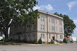
Moore County Courthouse, located in the center of Carthage | |
 Location in Moore County and the state of North Carolina. | |
| Coordinates: 35°19′46″N 79°24′31″W / 35.32944°N 79.40861°WCoordinates: 35°19′46″N 79°24′31″W / 35.32944°N 79.40861°W | |
| Country | United States |
| State | North Carolina |
| County | Moore |
| Government | |
| • Mayor | Lee McGraw[1] |
| Area | |
| • Total | 5.9 sq mi (15.2 km2) |
| • Land | 5.8 sq mi (15.1 km2) |
| • Water | 0.0 sq mi (0.1 km2) |
| Elevation | 617 ft (188 m) |
| Population (2010) | |
| • Total | 2,205 |
| • Density | 321.3/sq mi (124.1/km2) |
| Time zone | Eastern (EST) (UTC-5) |
| • Summer (DST) | EDT (UTC-4) |
| ZIP code | 28327 |
| Area code(s) | 910 |
| FIPS code | 37-10680[2] |
| GNIS feature ID | 1019550[3] |
| Website | http://townofcarthage.org/ |
Carthage is a town in Moore County, North Carolina, United States. The population was 2,205 at the 2010 Census. It is the county seat of Moore County.[4]
Geography
Carthage is located at 35°19′46″N 79°24′31″W / 35.32944°N 79.40861°W (35.329441, -79.408475).[5]
According to the United States Census Bureau, the town has a total area of 5.9 square miles (15 km2), of which, 5.8 square miles (15 km2) of it is land and 0.04 square miles (0.10 km2) of it (0.68%) is water.
Demographics
| Historical population | |||
|---|---|---|---|
| Census | Pop. | %± | |
| 1880 | 366 | — | |
| 1890 | 485 | 32.5% | |
| 1900 | 605 | 24.7% | |
| 1910 | 863 | 42.6% | |
| 1920 | 962 | 11.5% | |
| 1930 | 1,129 | 17.4% | |
| 1940 | 1,381 | 22.3% | |
| 1950 | 1,194 | −13.5% | |
| 1960 | 1,190 | −0.3% | |
| 1970 | 1,034 | −13.1% | |
| 1980 | 925 | −10.5% | |
| 1990 | 976 | 5.5% | |
| 2000 | 1,871 | 91.7% | |
| 2010 | 2,205 | 17.9% | |
| Est. 2015 | 2,395 | [6] | 8.6% |
As of the census[2] of 2000, there were 1,871 people, 653 households, and 440 families residing in the town. The population density was 321.3 people per square mile (124.1/km²). There were 768 housing units at an average density of 131.9 per square mile (50.9/km²). The racial makeup of the town was 67.72% White, 30.84% African American, 0.48% Native American, 0.05% Asian, 0.37% from other races, and 0.53% from two or more races. Hispanic or Latino of any race were 0.86% of the population.
There were 653 households out of which 28.5% had children under the age of 18 living with them, 49.0% were married couples living together, 14.9% had a female householder with no husband present, and 32.6% were non-families. 29.7% of all households were made up of individuals and 13.9% had someone living alone who was 65 years of age or older. The average household size was 2.42 and the average family size was 3.02.
In the town the population was spread out with 21.5% under the age of 18, 7.9% from 18 to 24, 26.5% from 25 to 44, 21.9% from 45 to 64, and 22.2% who were 65 years of age or older. The median age was 40 years. For every 100 females there were 86.0 males. For every 100 females age 18 and over, there were 86.1 males.
The median income for a household in the town was $35,050, and the median income for a family was $43,594. Males had a median income of $32,305 versus $23,603 for females. The per capita income for the town was $17,343. About 8.1% of families and 14.7% of the population were below the poverty line, including 13.4% of those under age 18 and 33.9% of those age 65 or over.
History

The town was the home of the Tyson Buggy Company, a predominant cart and buggy manufacturer in the 1800s. A common story told by residents is that after the closing of the Tyson Buggy Company, Henry Ford was interested in buying the old plant and converting it into a car assembly line. According to the legend, the owners refused to let Ford buy the plant and so he moved on to build a plant in Detroit. This story is often repeated despite a lack of evidence, and runs contrary to the established pattern of Ford (who was born and raised in Detroit) starting all of his businesses in Detroit. A few years afterwards, the Tyson Buggy plant burned down.
Another common story of folklore is that the town was originally to be the home of the University of North Carolina. In this story, however, city leaders determined that they didn't want the university built there. City leaders told the State that Carthage was on too steep of a hill for locomotives to climb and that access to the University would be limited if built there. This often-repeated story fails to take into consideration the fact that locomotives were not invented until two decades after the university had been built in Chapel Hill.
The town now has an annual event that takes place every spring called the Buggy Festival. This event is used to showcase the history of the town as well as show off music, hot rods, old tractors, old buggies made by the Tyson Buggy Company, and crafts from potteries in the surrounding areas. This event takes place in the town square around the Old Court House, considered to be a historic landmark.
The J.C. Black House, Daniel Blue House, Bruce-Dowd-Kennedy House, Carthage Historic District, Alexander Kelly House, and Moore County Courthouse are listed on the National Register of Historic Places.[8]
2009 shooting
On March 29, 2009, a man named Robert Stewart shot and killed eight people and wounded two others at the Pinelake Health and Rehab Center of Carthage.[9] Seven of the victims were elderly patients, with ages ranging from 75 to 98 years old. The eighth was a 39-year-old registered nurse who worked at the facility. The gunman, Robert Stewart, traded gunfire with a local police officer, wounding him in the leg before he himself was wounded and taken to a nearby medical facility.[10] Authorities identified the victims as Pinelake residents Tessie Garner, 75; Lillian Dunn, 89; Jesse Musser, 88; Bessie Hedrick, 78; John Goldston, 78; Margaret Johnson, 89; Louise DeKler, 98; and nurse Jerry Avant, 39.
References
- ↑ "Cape Fear Region Results". Fayetteville Observer. November 9, 2011.
- 1 2 "American FactFinder". United States Census Bureau. Archived from the original on 2013-09-11. Retrieved 2008-01-31.
- ↑ "US Board on Geographic Names". United States Geological Survey. 2007-10-25. Retrieved 2008-01-31.
- ↑ "Find a County". National Association of Counties. Archived from the original on 2011-05-31. Retrieved 2011-06-07.
- ↑ "US Gazetteer files: 2010, 2000, and 1990". United States Census Bureau. 2011-02-12. Retrieved 2011-04-23.
- ↑ "Annual Estimates of the Resident Population for Incorporated Places: April 1, 2010 to July 1, 2015". Retrieved July 2, 2016.
- ↑ "Census of Population and Housing". Census.gov. Archived from the original on April 22, 2013. Retrieved June 4, 2015.
- ↑ National Park Service (2010-07-09). "National Register Information System". National Register of Historic Places. National Park Service.
- ↑ Gunman kills six at US care home BBC - Sunday, 29 March 2009
- ↑ Eight dead in Carthage nursing-home shooting - WRAL.com, March 29, 2009.
External links
Municipalities and communities of Moore County, North Carolina, United States | ||
|---|---|---|
| City |  | |
| Towns | ||
| Villages | ||
| CDP | ||
| Unincorporated communities | ||