Robbins, North Carolina
| Robbins, North Carolina | |
|---|---|
| City | |
|
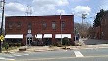
Central business district of Robbins | |
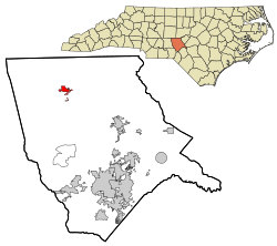 Location in Moore County and the state of North Carolina. | |
| Coordinates: 35°25′48″N 79°34′49″W / 35.43000°N 79.58028°WCoordinates: 35°25′48″N 79°34′49″W / 35.43000°N 79.58028°W | |
| Country | United States |
| State | North Carolina |
| County | Moore |
| Government | |
| • Mayor | Lonnie B. English [1] |
| Area | |
| • Total | 1.3 sq mi (3.3 km2) |
| • Land | 1.3 sq mi (3.3 km2) |
| • Water | 0.0 sq mi (0.0 km2) |
| Elevation | 440 ft (134 m) |
| Population (2010) | |
| • Total | 1,097 |
| • Density | 935.1/sq mi (361.1/km2) |
| Time zone | Eastern (EST) (UTC-5) |
| • Summer (DST) | EDT (UTC-4) |
| ZIP code | 27325 |
| Area code(s) | 910 |
| FIPS code | 37-57000[2] |
| GNIS feature ID | 0993441[3] |

Robbins is a city in Moore County, North Carolina, United States. The population was 1,097 at the 2010 census.
History
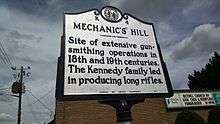
The Town, now known as Robbins, actually began in 1795 when gunsmith Alexander Kennedy and his family left Philadelphia to settle along Bear Creek. Kennedy set up a factory, which produced long rifles for American soldiers, near the site of the present day Robbins Water Plant. The Kennedy rifle works continued in operation until 1838 and the place became known as Mechanics Hill.
In 1891, the Durham and Charlotte Railroad railway connected Gulf, in Chatham County, to Troy, in Montgomery County. The railroad reached Mechanics Hill around 1899. Railroad construction added many jobs and greatly increased the number of settlers. The railroad not only created its own jobs, it generated commerce by providing a ready means of transportation for turpentine, talc, pottery, lumber, agricultural products, and passengers. John B. Lennig was President and owner of the company. Mr. Lennig was here, off and on, for about 12 years. During that time, town lots and streets were designed. A map was registered at the Moore County Register of Deeds Office on March 24, 1900 and the Town was named Elise, in honor of Lennig's daughter.
In 1896, the John L. Frye Company, a producer of lumber for the rail and pallet industries, was established. Railroads across the US are supported by cross ties still made here in Robbins today.
Education was a major concern for the citizens of Elise and the surrounding communities. Some local businessmen and Mr. Lennig met many times to discuss these concerns. These meetings resulted in the founding of Elise Academy in 1904. The academy had a very proud standing and children from here, and from other states and countries, attended this first class establishment. Elise Academy operated until 1940, when it was sold to the Moore County Board of Education.
In 1890,the great inventor Thomas Edison came down to take option on gold mining interests in the Carter's Mill area. Between 1923 and 1924, generators were installed at Carter’s Mill, along Bear Creek, adjacent to Elise, and the first power was supplied to this area. In 1924 and 1925, William Cowgill built the first textile plant here, operating it as Moore Mills Textiles Plant. Three different companies operated that mill until September, 1930, when Karl Robbins, a Russian immigrant, purchased the mill and renamed it Pinehurst Silk Mills.
In 1935, the Town’s name was changed again. The name was changed to Hemp, to avoid confusion between Elise and another town in North Carolina which had a similar name. Karl Robbins brought great prominence to Hemp. He was responsible for a modern water treatment plant and a wastewater disposal system being completed in 1937. He also provided for recreational facilities and a baseball park.
In honor of Karl Robbins, the citizens of Hemp changed the name to Robbins. The town officially became Robbins in 1943, by act of the General Assembly.
Later industries included a poultry processing plant, a mobile home manufacturing plant, and several textile mills. Ithaca Industries produced ladies hosiery and at the height of its operation, employed 1,100 people.
Robbins, like other rural towns in the South, began to suffer loss to its manufacturing base around 1990 and escalated throughout the 90s. According to the Employment Security Commission, Robbins has lost 1,447 jobs since 1990. The town has also lost a very large portion of its water and sewer customer.
Geography
Robbins is located at 35°25′48″N 79°34′49″W / 35.43000°N 79.58028°W (35.430024, -79.580284).[4]
Robbins is located on North Carolina Highway 705, the Pottery Highway.
According to the United States Census Bureau, the city has a total area of 1.3 square miles (3.4 km2), all of it land.
Demographics
| Historical population | |||
|---|---|---|---|
| Census | Pop. | %± | |
| 1940 | 972 | — | |
| 1950 | 1,158 | 19.1% | |
| 1960 | 1,294 | 11.7% | |
| 1970 | 1,059 | −18.2% | |
| 1980 | 1,256 | 18.6% | |
| 1990 | 970 | −22.8% | |
| 2000 | 1,195 | 23.2% | |
| 2010 | 1,097 | −8.2% | |
| Est. 2015 | 1,184 | [5] | 7.9% |
As of the census[2] of 2000, there were 1,195 people, 423 households, and 286 families residing in the city. The population density was 935.1 people per square mile (360.5/km²). There were 471 housing units at an average density of 368.6 per square mile (142.1/km²). The racial makeup of the city was 63.60% White, 2.34% African American, 0.33% Native American, 0.17% Asian, 0.42% Pacific Islander, 32.30% from other races, and 0.84% from two or more races. Hispanic or Latino of any race were 48.37% of the population.
There were 423 households out of which 33.8% had children under the age of 18 living with them, 50.1% were married couples living together, 12.1% had a female householder with no husband present, and 32.2% were non-families. 29.1% of all households were made up of individuals and 16.3% had someone living alone who was 65 years of age or older. The average household size was 2.81 and the average family size was 3.45.
In the city the population was spread out with 28.5% under the age of 18, 12.1% from 18 to 24, 28.7% from 25 to 44, 16.2% from 45 to 64, and 14.5% who were 65 years of age or older. The median age was 31 years. For every 100 females there were 102.2 males. For every 100 females age 18 and over, there were 95.7 males.
The median income for a household in the city was $28,828, and the median income for a family was $33,523. Males had a median income of $21,346 versus $17,391 for females. The per capita income for the city was $14,468. About 18.4% of families and 22.0% of the population were below the poverty line, including 31.1% of those under age 18 and 10.7% of those age 65 or over.
Robbins today
There are many attractions in the Robbins area such as the annual Farmers Day, the Northern Moore Fiddlers Convention, etc. The most popular places in Robbins are Milliken (mill-a-ken) Park, Robbins Mill Pond Park, Bear Creek Trails, Bear Creek, Tracy Brown Park, Jake's Place Cafe, Carolina Fried Chicken Restaurant, The Little Village Restaurant and War Sport Industries. Currently, Robbins is in the middle of restoring its historic theater and train depot. It is also home to the Standard Mineral Company, a mine on the outskirts of town that ships Pyrophyllite all over the world. War Sport Industries is maintaining the towns heritage of gun manufacturing with the opening of gun and ammo manufacturing facilities. Robbins regularly host Robin Sage, a training exercise by the United States ArmySpecial Forces that is the litmus test for soldiers striving to earn the coveted Green Beret.
Notable people
- John Edwards, American politician, former US Senator, two-time Presidential candidate, 2004 Vice-Presidential running mate of John Kerry, grew up in Robbins (he was born in Seneca, South Carolina).
- Charles E. Brady Jr., Astronaut, flew on space shuttle STS-78 in 1996 and logged over 405 hours in space.
- Cam Thomas, NFL Football player for the Los Angeles Rams. He played for the Pittsburgh Steelers for 2 seasons after becoming a free agent from the San Diego Chargers. Originally drafted in the 5th round of the 2010 NFL Draft by the San Diego Chargers. Played high school football at North Moore High School, and college football at the University of North Carolina.
References
- ↑ "Cape Fear Region Results". Fayetteville Observer. November 9, 2011.
- 1 2 "American FactFinder". United States Census Bureau. Retrieved 2008-01-31.
- ↑ "US Board on Geographic Names". United States Geological Survey. 2007-10-25. Retrieved 2008-01-31.
- ↑ "US Gazetteer files: 2010, 2000, and 1990". United States Census Bureau. 2011-02-12. Retrieved 2011-04-23.
- ↑ "Annual Estimates of the Resident Population for Incorporated Places: April 1, 2010 to July 1, 2015". Retrieved July 2, 2016.
- ↑ "Census of Population and Housing". Census.gov. Retrieved June 4, 2015.
http://familytreemaker.genealogy.com/users/c/a/g/Florence-Cagle-Alabama/BOOK-0001/0002-0004.html
External links
Municipalities and communities of Moore County, North Carolina, United States | ||
|---|---|---|
| City |  | |
| Towns | ||
| Villages | ||
| CDP | ||
| Unincorporated communities | ||