Atlantic coastal plain
.jpg)
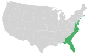
The Atlantic coastal plain is a physiographic region of low relief along the East Coast of the United States. It extends 2,200 miles (3,500 km) from the New York Bight[2][3] southward to a Georgia/Florida section of the Eastern Continental Divide, which demarcates the plain from the ACF River Basin in the Gulf Coastal Plain to the west. The province is bordered on the west by the Atlantic Seaboard fall line and the Piedmont plateau, to the east by the Atlantic Ocean, and to the south by the Floridian province. The Outer Lands archipelagic region forms the insular northeasternmost extension of the Atlantic coastal plain.
The province's average elevation is less than 900 meters above sea level and extends some 50 to 100 kilometers inland from the ocean. The coastal plain is normally wet, including many rivers, marsh, and swampland. It is composed primarily of sedimentary rock and unlithified sediments and is primarily used for agriculture.[4] The area is subdivided into the Embayed and Sea Island physiographic provinces, as well as the Mid-Atlantic and South Atlantic coastal plains.
References
- ↑ "Generalized Landscape Regions of New York State" (PDF). Earth Science Reference Tables. NYSED. Retrieved 12 November 2012.
- ↑ Stoffer, Phil; Messina, Paula. "The Atlantic Coastal Plain". Geology and Geography of New York Bight Beaches.
- ↑ "South Atlantic Coastal Plain". Archived from the original on 2009-04-24.
- ↑ Water table management in the eastern coastal plain Archived July 21, 2011, at the Wayback Machine.