Norfolk Auto Row Historic District
|
Norfolk Auto Row Historic District | |
|
| |
  | |
| Location | Roughly bounded by E. 14th, Llewellyn Ave., Boush & Granby Sts., Monticello & W. Brambleton Aves., Norfolk, Virginia |
|---|---|
| Coordinates | 36°51′29″N 76°17′22″W / 36.85806°N 76.28944°WCoordinates: 36°51′29″N 76°17′22″W / 36.85806°N 76.28944°W |
| Area | 53.7 acres (21.7 ha) |
| NRHP Reference # | 14000529[1] |
| Added to NRHP | August 25, 2014 |
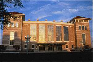
The Norfolk Auto Row Historic District encompasses a commercial district just outside the downtown area of Norfolk, Virginia. The area is bounded on the south by West Brambleton Avenue, on the east by Monticello Avenue, on the north by East 13th Street, and on the west by Llewelllyn Avenue and Granby and Boush streets. The area was originally developed as a low-income housing area early in the 20th century, but was by the mid-20th century completely transformed into an area of commercial development, mainly for the sales and service of automobiles. The district features buildings that are mostly one and two stories, although there is one 14-story skyscraper. One notable structure in the district is the Harrison Opera House, built in 1944 as an Army and Navy USO facility; it served as the city's major performance venue until it was eclipsed in 1970 by the construction of the Norfolk Scope arena.[2]
The district was listed on the National Register of Historic Places in 2014.[1]
See also
References
- 1 2 National Park Service (2010-07-09). "National Register Information System". National Register of Historic Places. National Park Service.
- ↑ "NRHP nomination for Norfolk Auto Row Historic District" (PDF). Virginia DHR. Retrieved 2014-09-07.

