Nikolai, Alaska
| Nikolai | |
|---|---|
| City | |
.jpg) | |
 Nikolai Location in Alaska | |
| Coordinates: 63°0′39″N 154°23′2″W / 63.01083°N 154.38389°WCoordinates: 63°0′39″N 154°23′2″W / 63.01083°N 154.38389°W | |
| Country | United States |
| State | Alaska |
| Census Area | Yukon-Koyukuk |
| Incorporated | July 9, 1970[1] |
| Government | |
| • Mayor | Tamara Roberts[2] |
| • State senator | Lyman Hoffman (D) |
| • State rep. | Bryce Edgmon (D) |
| Area | |
| • Total | 4.9 sq mi (12.6 km2) |
| • Land | 4.5 sq mi (11.7 km2) |
| • Water | 0.3 sq mi (0.9 km2) |
| Elevation | 427 ft (130 m) |
| Population (2007)[3] | |
| • Total | 88 |
| • Density | 22.1/sq mi (8.5/km2) |
| Time zone | Alaska (AKST) (UTC-9) |
| • Summer (DST) | AKDT (UTC-8) |
| ZIP code | 99691 |
| Area code | 907 |
| FIPS code | 02-54150 |
Nikolai is a city in Yukon-Koyukuk Census Area, Alaska, United States. The population was 94 as of the 2010 census.
Geography
Nikolai is located at 63°0′39″N 154°23′2″W / 63.01083°N 154.38389°W (63.010838, -154.383895).[4]
According to the United States Census Bureau, the city has a total area of 4.9 square miles (13 km2), of which, 4.5 square miles (12 km2) of it is land and 0.3 square miles (0.78 km2) of it (7.17%) is water.
Demographics
| Historical population | |||
|---|---|---|---|
| Census | Pop. | %± | |
| 1950 | 88 | — | |
| 1960 | 85 | −3.4% | |
| 1970 | 112 | 31.8% | |
| 1980 | 91 | −18.7% | |
| 1990 | 109 | 19.8% | |
| 2000 | 100 | −8.3% | |
| 2010 | 94 | −6.0% | |
| Est. 2015 | 93 | [5] | −1.1% |
As of the census[7] of 2000, there were 100 people, 40 households, and 23 families residing in the city. The population density was 22.1 people per square mile (8.5/km²). There were 47 housing units at an average density of 10.4 per square mile (4.0/km²). The racial makeup of the city was 19% White and 81% Native American.
There were 40 households out of which 27.5% had children under the age of 18 living with them, 37.5% were married couples living together, 7.5% had a female householder with no husband present, and 42.5% were non-families. 42.5% of all households were made up of individuals and 7.5% had someone living alone who was 65 years of age or older. The average household size was 2.50 and the average family size was 3.35.
In the city the age distribution of the population shows 27.0% under the age of 18, 6.0% from 18 to 24, 24.0% from 25 to 44, 26.0% from 45 to 64, and 17.0% who were 65 years of age or older. The median age was 40 years. For every 100 females there were 194.1 males. For every 100 females age 18 and over, there were 160.7 males.
The median income for a household in the city was $15,000, and the median income for a family was $15,417. The per capita income for the city was $11,029. There were 21.1% of families and 27.6% of the population living below the poverty line, including 22.2% of under eighteens and 15.8% of those over 64.
References
- ↑ "Directory of Borough and City Officials 1974". Alaska Local Government. Juneau: Alaska Department of Community and Regional Affairs. XIII (2): 58. January 1974.
- ↑ 2015 Alaska Municipal Officials Directory. Juneau: Alaska Municipal League. 2015. p. 111.
- ↑ "Annual Estimates of the Population for Incorporated Places in Alaska". United States Census Bureau. 2008-07-10. Retrieved 2008-07-14.
- ↑ "US Gazetteer files: 2010, 2000, and 1990". United States Census Bureau. 2011-02-12. Retrieved 2011-04-23.
- ↑ "Annual Estimates of the Resident Population for Incorporated Places: April 1, 2010 to July 1, 2015". Retrieved July 2, 2016.
- ↑ "Census of Population and Housing". Census.gov. Archived from the original on May 11, 2015. Retrieved June 4, 2015.
- ↑ "American FactFinder". United States Census Bureau. Archived from the original on September 11, 2013. Retrieved 2008-01-31.
External links
-
 Media related to Nikolai, Alaska at Wikimedia Commons
 - Student film on Nikolai
Municipalities and communities of Yukon–Koyukuk Census Area, Alaska, United States | ||
|---|---|---|
| Cities | 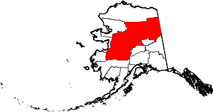 | |
| CDPs | ||
| Unincorporated communities | ||
| Ghost towns | ||