Bettles, Alaska
| Bettles Kk’odlel T’odegheelenh Denh | |
|---|---|
| City | |
|
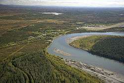
Aerial view of Bettles (right) and its neighbor Evansville (left) | |
 Location in Alaska | |
| Coordinates: 66°54′48″N 151°31′21″W / 66.91333°N 151.52250°WCoordinates: 66°54′48″N 151°31′21″W / 66.91333°N 151.52250°W | |
| Country | United States |
| State | Alaska |
| Census Area | Yukon-Koyukuk |
| Incorporated | December 20, 1985[1] |
| Government | |
| • Mayor | Heather J. Fox |
| • State senator | Donald Olson (D) |
| • State rep. | Benjamin Nageak (D) |
| Area | |
| • Total | 1.6 sq mi (4.2 km2) |
| • Land | 1.6 sq mi (4.2 km2) |
| • Water | 0 sq mi (0 km2) 0% |
| Elevation | 630 ft (200 m) |
| Population (2010) | |
| • Total | 12 |
| • Density | 7.5/sq mi (2.9/km2) |
| Time zone | Alaska (AKST) (UTC-9) |
| • Summer (DST) | AKDT (UTC-8) |
| ZIP code | 99726 |
| Area code | 907 Exchange: 692 |
| FIPS code | 02-06630 |
Bettles (Kk’odlel T’odegheelenh Denh in Koyukon) is a city in Yukon-Koyukuk Census Area, Alaska, United States. The population was 12 at the 2010 census.
History
The city was founded in 1896 during the Alaska Gold Rush. The airstrip that serves the community was built in World War II and is now used for commercial air service. The Hickel Highway was used to transport equipment and supplies to the North Slope for oil exploration, and to build the Dalton Highway, which is now used as a truck route to the oilfields.
Demographics
| Historical population | |||
|---|---|---|---|
| Census | Pop. | %± | |
| 1930 | 23 | — | |
| 1940 | 10 | −56.5% | |
| 1950 | 47 | 370.0% | |
| 1960 | 77 | 63.8% | |
| 1990 | 36 | — | |
| 2000 | 43 | 19.4% | |
| 2010 | 12 | −72.1% | |
| Est. 2015 | 12 | [2] | 0.0% |
As of the census[4] of 2000, there were 43 people, 16 households, and 9 families residing in the city. The population density was 26.2 people per square mile (10.1/km²). There were 36 housing units at an average density of 21.9/sq mi (8.5/km²). The racial makeup of the city was 76.74% White, 18.60% Native American, and 4.65% from two or more races.
There were 16 households out of which 37.5% had children under the age of 18 living with them, 50.0% were married couples living together, 6.3% had a female householder with no husband present, and 43.8% were non-families. 18.8% of all households were made up of individuals and none had someone living alone who was 65 years of age or older. The average household size was 2.69 and the average family size was 3.44.
In the city the population was spread out with 30.2% under the age of 18, 7.0% from 18 to 24, 37.2% from 25 to 44, 25.6% from 45 to 64. The median age was 34 years. For every 100 females there were 104.8 males. For every 100 females age 18 and over, there were 130.8 males.
The median income for a household in the city was $49,375, and the median income for a family was $65,000. Males had a median income of $47,917 versus $48,750 for females. The per capita income for the city was $19,585. There were 10.0% of families and 6.4% of the population living below the poverty line, including 11.1% of under eighteens and none of those over 64.
Geography
Bettles is located on the southeast bank of the Koyukuk River at 66°54′48″N 151°31′21″W / 66.91333°N 151.52250°W (66.913419, −151.522374).[5] The city is on the former Hickel Highway,[6] that now connects to the Dalton Highway as a winter ice road only and crosses the Jim River (Alaska). Bettles is 35 miles (56 km) north of the Arctic Circle just south of the Brooks Range. The city is also served by a 5,190-foot (1,580 m) gravel airstrip built by the military.
According to the United States Census Bureau, the city has a total area of 1.6 square miles (4.1 km2), all of it land.
Climate
As is typical of the Alaska Interior, Bettles experiences a subarctic climate (Köppen Dfc) with very long, frigid winters and short, warm summers, and is located in USDA Plant Hardiness Zone 1,[7] indicating the coldest temperature of the year is typically at or below −50 °F (−45.6 °C). Temperatures usually remain consistently below freezing from late October to late March, and the bulk of the year’s snow occurs from October to April, with generally light accumulations in May and September; the average annual snowfall stands at 91 inches (2.31 m). In summer, temperatures reach 70 °F (21.1 °C) on 37 days and 80 °F (26.7 °C) on 6.4, with an average of 1 night not falling below 60 °F (15.6 °C). The threat of frost usually begins in late August, but sometimes it can happen during the first half of that month. A majority of the annual precipitation of 14.9 inches (378 mm) occurs during summer as well. Extreme temperatures have ranged from −70 °F (−56.7 °C) up to 93 °F (33.9 °C).
| Climate data for Bettles, Alaska (1981−2010 normals, extremes 1944−present) | |||||||||||||
|---|---|---|---|---|---|---|---|---|---|---|---|---|---|
| Month | Jan | Feb | Mar | Apr | May | Jun | Jul | Aug | Sep | Oct | Nov | Dec | Year |
| Record high °F (°C) | 42 (6) |
40 (4) |
49 (9) |
66 (19) |
86 (30) |
92 (33) |
93 (34) |
88 (31) |
79 (26) |
57 (14) |
45 (7) |
38 (3) |
93 (34) |
| Average high °F (°C) | −2.2 (−19) |
4.5 (−15.3) |
16.7 (−8.5) |
34.3 (1.3) |
54.6 (12.6) |
69.3 (20.7) |
69.8 (21) |
62.1 (16.7) |
48.9 (9.4) |
25.6 (−3.6) |
6.0 (−14.4) |
1.9 (−16.7) |
32.8 (0.4) |
| Average low °F (°C) | −17.9 (−27.7) |
−14.5 (−25.8) |
−8 (−22) |
12.3 (−10.9) |
34.2 (1.2) |
47.6 (8.7) |
49.6 (9.8) |
42.9 (6.1) |
32.3 (0.2) |
12.1 (−11.1) |
−8.1 (−22.3) |
−13.4 (−25.2) |
14.2 (−9.9) |
| Record low °F (°C) | −70 (−57) |
−64 (−53) |
−56 (−49) |
−37 (−38) |
−10 (−23) |
27 (−3) |
29 (−2) |
15 (−9) |
−11 (−24) |
−35 (−37) |
−57 (−49) |
−60 (−51) |
−70 (−57) |
| Average precipitation inches (mm) | 0.81 (20.6) |
0.85 (21.6) |
0.58 (14.7) |
0.60 (15.2) |
0.88 (22.4) |
1.40 (35.6) |
2.36 (59.9) |
2.64 (67.1) |
1.91 (48.5) |
1.04 (26.4) |
0.91 (23.1) |
0.92 (23.4) |
14.90 (378.5) |
| Average snowfall inches (cm) | 13.9 (35.3) |
14.0 (35.6) |
9.3 (23.6) |
6.3 (16) |
1.3 (3.3) |
0 (0) |
0 (0) |
0 (0) |
2.5 (6.4) |
12.4 (31.5) |
16.1 (40.9) |
15.6 (39.6) |
91.4 (232.2) |
| Average precipitation days (≥ 0.01 in) | 9.0 | 9.0 | 7.3 | 6.4 | 8.3 | 10.8 | 13.5 | 14.6 | 12.2 | 12.0 | 10.6 | 11.4 | 125.1 |
| Average snowy days (≥ 0.1 in) | 10.0 | 10.3 | 8.1 | 5.6 | 1.2 | 0 | 0 | 0 | 2.1 | 11.4 | 11.5 | 12.5 | 72.7 |
| Average relative humidity (%) | 68.6 | 67.0 | 65.3 | 67.2 | 60.7 | 59.8 | 67.7 | 75.8 | 75.6 | 77.7 | 73.5 | 71.7 | 69.2 |
| Source: NOAA (relative humidity 1961–1990),[8][9][10] Weather.com[11] | |||||||||||||
References
- ↑ 1996 Alaska Municipal Officials Directory. Juneau: Alaska Municipal League/Alaska Department of Community and Regional Affairs. January 1996. p. 33.
- ↑ "Annual Estimates of the Resident Population for Incorporated Places: April 1, 2010 to July 1, 2015". Retrieved July 2, 2016.
- ↑ "Census of Population and Housing". Census.gov. Archived from the original on May 11, 2015. Retrieved June 4, 2015.
- ↑ "American FactFinder". United States Census Bureau. Archived from the original on 2013-09-11. Retrieved 2008-01-31.
- ↑ "US Gazetteer files: 2010, 2000, and 1990". United States Census Bureau. 2011-02-12. Retrieved 2011-04-23.
- ↑ http://niyachen.blogspot.com/2007/05/hickels-highway.html
- ↑
- ↑ "Station Name: AK BETTLES AP". National Oceanic and Atmospheric Administration. Retrieved 2013-03-10.
- ↑ "NOWData - NOAA Online Weather Data". National Oceanic and Atmospheric Administration. Retrieved 2013-04-23.
- ↑ "WMO Climate Normals for BETTLES/FIELD AK 1961–1990". National Oceanic and Atmospheric Administration. Retrieved 2014-03-23.
- ↑ "Average Weather for Bettles, AK − Temperature and Precipitation". The Weather Channel. Retrieved 2013-03-11.
| Wikimedia Commons has media related to Bettles, Alaska. |
Municipalities and communities of Yukon–Koyukuk Census Area, Alaska, United States | ||
|---|---|---|
| Cities |  | |
| CDPs | ||
| Unincorporated communities | ||
| Ghost towns | ||