New Holland, Pennsylvania
| New Holland | |
|---|---|
| Borough | |
|
200 West Main Street | |
| Etymology: Holland | |
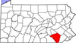
 Location of New Holland in Lancaster County | |
 New Holland Location of New Holland in Pennsylvania | |
| Coordinates: 40°06′08″N 76°05′16″W / 40.10222°N 76.08778°WCoordinates: 40°06′08″N 76°05′16″W / 40.10222°N 76.08778°W | |
| Country | United States |
| State | Pennsylvania |
| County | Lancaster |
| Government | |
| • Mayor | Wilbur G. Horning |
| Area | |
| • Total | 2.1 sq mi (5 km2) |
| • Land | 2.1 sq mi (5 km2) |
| • Water | 0 sq mi (0 km2) |
| Elevation | 495 ft (151 m) |
| Population (2010) | |
| • Total | 5,378 |
| • Density | 2,600/sq mi (990/km2) |
| Time zone | EST (UTC-5) |
| • Summer (DST) | EDT (UTC-4) |
| ZIP code | 17557 |
| Area code(s) | 717 Exchanges: 351,354,355 |
| Website | |

New Holland (Pennsylvania Dutch: Seischwamm) is a borough in Lancaster County, Pennsylvania, USA. As of the 2010 United States Census, the population was 5,378, up from 5,092 in the 2000 United States Census.
History
New Holland was settled in 1728 by John Michael and John Phillip Ranc (Ranck). Before it became known as New Holland, it had been called Hog Swamp, Earltown and New Design.[1] New Holland, Pennsylvania is the twin city of Longvic, France.[2]
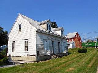
The New Holland Machine Company and John Casper Stoever Log House are listed on the National Register of Historic Places.[3]
Geography
New Holland is located at 40°6′8″N 76°5′16″W / 40.10222°N 76.08778°W (40.102095, -76.087646).[4] According to the United States Census Bureau, the borough has a total area of 2.1 square miles (5.4 km2), all of it land.
Demographics
| Historical population | |||
|---|---|---|---|
| Census | Pop. | %± | |
| 1850 | 672 | — | |
| 1870 | 778 | — | |
| 1880 | 1,005 | 29.2% | |
| 1890 | 1,060 | 5.5% | |
| 1900 | 902 | −14.9% | |
| 1910 | 1,106 | 22.6% | |
| 1920 | 1,453 | 31.4% | |
| 1930 | 1,725 | 18.7% | |
| 1940 | 2,153 | 24.8% | |
| 1950 | 2,602 | 20.9% | |
| 1960 | 3,425 | 31.6% | |
| 1970 | 3,971 | 15.9% | |
| 1980 | 4,147 | 4.4% | |
| 1990 | 4,484 | 8.1% | |
| 2000 | 5,092 | 13.6% | |
| 2010 | 5,378 | 5.6% | |
| Est. 2015 | 5,430 | [5] | 1.0% |
| Sources:[6][7][8] | |||
As of the census[7] of 2000, there were 5,092 people, 2,084 households, and 1,448 families residing in the borough. The population density was 2,444.2 people per square mile (945.2/km²). There were 2,159 housing units at an average density of 1,036.3 per square mile (400.8/km²). The racial makeup of the borough was 90.34% White, 1.02% African American, 0.08% Native American, .025% Asian, 0.02% Pacific Islander, 2.57% from other races, and 1.67% from two or more races. Hispanic or Latino of any race were 6.42% of the population.
In the borough the population was spread out, with 22.4% under the age of 18, 8.1% from 18 to 24, 28.6% from 25 to 44, 24.9% from 45 to 64, and 16.1% who were 65 years of age or older. The median age was 40 years. For every 100 females there were 95.3 males. For every 100 females age 18 and over, there were 94.1 males.
The median income for a household in the borough was $44,446, and the median income for a family was $50,758. Males had a median income of $37,002 versus $25,766 for females. The per capita income for the borough was $20,187. About 3.4% of families and 5.2% of the population were below the poverty line, including 7.5% of those under age 18 and 1.5% of those age 65 or over.
Public services
Education
The Eastern Lancaster County School District has its district headquarters in New Holland, Pennsylvania. This site also houses both Garden Spot High School and Garden Spot Middle School. Elementary schools within the district include: New Holland, Blue Ball and Brecknock.
This area is served by the Eastern Lancaster County Library http://www.elancolibrary.org (ELANCO Library), formerly known as New Holland Library. The ELANCO Library is located on Chestnut St. in New Holland and is a member of the Library System of Lancaster County.
Culture
The New Holland Farmer's Fair is an annual festival held in New Holland.[9]
-
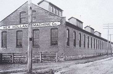
New Holland Machine Company, c. 1895
-

New Holland Borough Sign in front of Garden Spot High School
-
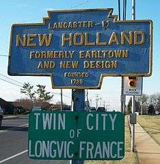
Keystone marker and Sister City sign on route 23 near Garden Spot High School
References
- ↑ "A Brief History of New Holland". Retrieved 2009-01-07.
- ↑ "History". Retrieved 2008-12-15.
- ↑ National Park Service (2010-07-09). "National Register Information System". National Register of Historic Places. National Park Service.
- ↑ "US Gazetteer files: 2010, 2000, and 1990". United States Census Bureau. 2011-02-12. Retrieved 2011-04-23.
- ↑ "Annual Estimates of the Resident Population for Incorporated Places: April 1, 2010 to July 1, 2015". Retrieved July 2, 2016.
- ↑ "Census of Population and Housing". U.S. Census Bureau. Retrieved 11 December 2013.
- 1 2 "American FactFinder". United States Census Bureau. Retrieved 2008-01-31.
- ↑ "Incorporated Places and Minor Civil Divisions Datasets: Subcounty Resident Population Estimates: April 1, 2010 to July 1, 2012". Population Estimates. U.S. Census Bureau. Retrieved 11 December 2013.
- ↑ "New Holland Farmers Fair". Pcrdesigns.net. Retrieved 12 April 2014.
- http://ranck.org/Joomla/index.php?option=com_content&task=view&id=218&Itemid=202" The Ranks of the Ranks "A history of the Ranck (Ranc) Family in Lancaster County"