Hunsecker, Pennsylvania
This article is about Hunsecker, a community in Pennsylvania. For Hunsecker, the surname, see Hunziker.
| Hunsecker | |
|---|---|
| Unincorporated community | |
 Hunsecker Location within the state of Pennsylvania | |
| Coordinates: 40°5′8″N 76°14′39″W / 40.08556°N 76.24417°WCoordinates: 40°5′8″N 76°14′39″W / 40.08556°N 76.24417°W | |
| Country | United States |
| State | Pennsylvania |
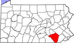
| County | Lancaster |
| Elevation | 312 ft (95 m) |
| Time zone | Eastern (EST) (UTC-5) |
| • Summer (DST) | EDT (UTC-4) |
| GNIS feature ID | 1203859[1] |
Hunsecker is an unincorporated community located in Upper Leacock Township, Lancaster County, Pennsylvania at latitude 40.08556 and longitude -76.24444. The elevation is 308 feet. Hunsecker appears on the Leola U.S. Geological Survey Map and is part of the Lower Susquehanna watershed. Lancaster County is in the Eastern time zone (UTC-5). Hunsecker is located at the vicinity of the intersection of Hunsecker Road (SR 1029, also listed as Hunsicker Road) with Mondale Road, just north of New Holland Pike, east of Holland Heights, and west of Leacock. Nearby is Hunsecker's Mill Covered Bridge spanning the Conestoga River.
References
This article is issued from Wikipedia - version of the 10/30/2016. The text is available under the Creative Commons Attribution/Share Alike but additional terms may apply for the media files.