Brownstown, Lancaster County, Pennsylvania
| Brownstown, Pennsylvania | |
|---|---|
| census-designated place | |
 Brownstown Location within the state of Pennsylvania | |
| Coordinates: 40°07′25″N 76°12′50″W / 40.12361°N 76.21389°WCoordinates: 40°07′25″N 76°12′50″W / 40.12361°N 76.21389°W | |
| Country | United States |
| State | Pennsylvania |
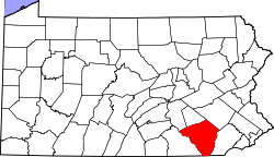
| County | Lancaster |
| Area | |
| • Total | 0.25 sq mi (0.66 km2) |
| Population (2010) | |
| • Total | 2,816 |
| • Density | 11,000/sq mi (4,300/km2) |
| Time zone | Eastern (EST) (UTC-5) |
| • Summer (DST) | EDT (UTC-4) |
| ZIP code | 17508 |
| Area code(s) | 717 |
| GNIS feature ID | 1170414[1] |
Brownstown, Pennsylvania is an unincorporated community and a census-designated place located within West Earl Township in Lancaster County, Pennsylvania. As of the 2010 census the population was 2,816 residents.
Geography
The town has a total land area of 0.66 square kilometers. It is situated southwest of Ephrata and northeast of the city of Lancaster.
The main route through Brownstown is Pennsylvania Route 772 (South State Street), which runs through the center of Brownstown. U.S. Route 222 run just to the west of the center of town. Route 272 runs just parallel to Route 222. The intersection of routes 772 and 272 is currently one of the most heavily traveled areas In Lancaster County.
Demographics
The population is approximately 937.