Caernarvon Township, Lancaster County, Pennsylvania
Coordinates: 40°08′13″N 75°57′29″W / 40.13694°N 75.95806°W
| Caernarvon Township, Lancaster County, Pennsylvania | |
|---|---|
| Township | |
|
A snow squall over Caernarvon Township | |
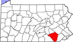
 Map of Lancaster County highlighting Caernarvon Township | |
| Country | United States |
| State | Pennsylvania |
| County | Lancaster |
| Settled | 1730 |
| Incorporated | 1729 |
| Government | |
| • Type | Board of Supervisors |
| • Chairman | Gary Van Dyke |
| • Member | Douglas Maitland |
| • Member | Steve Nichols |
| Area | |
| • Total | 23.0 sq mi (59.5 km2) |
| Population (2000) | |
| • Total | 4,278 |
| • Density | 186.2/sq mi (71.9/km2) |
| Time zone | Eastern (EST) (UTC-5) |
| • Summer (DST) | EDT (UTC-4) |
| Area code(s) | 610, 717 |
| Website | |

Caernarvon Township is a township in northeastern Lancaster County, Pennsylvania, United States. For the 2000 census the population was 4,278.
History
The Bangor Episcopal Church, Ann Cunningham Evans House, Edward Davies House, Pool Forge Covered Bridge, Poole Forge, Weaver's Mill Covered Bridge, and Windsor Forge Mansion are listed on the National Register of Historic Places.[1]
Geography
According to the United States Census Bureau, the township has a total area of 23.0 square miles (60 km2), all of it land.
Demographics
As of the census[2] of 2000, there were 4,278 people, 1,269 households, and 1,079 families residing in the township. The population density was 186.2 people per square mile (71.9/km²). There were 1,303 housing units at an average density of 56.7/sq mi (21.9/km²). The racial makeup of the township was 98.90% White, 0.49% African American, 0.09% Native American, 0.26% Asian, 0.05% from other races, and 0.21% from two or more races. Hispanic or Latino of any race were 0.65% of the population.
There were 1,269 households, out of which 42.6% had children under the age of 18 living with them, 76.8% were married couples living together, 5.0% had a female householder with no husband present, and 14.9% were non-families. 12.1% of all households were made up of individuals, and 5.4% had someone living alone who was 65 years of age or older. The average household size was 3.27 and the average family size was 3.58.
In the township the population was spread out, with 31.9% under the age of 18, 9.1% from 18 to 24, 26.4% from 25 to 44, 21.6% from 45 to 64, and 11.1% who were 65 years of age or older. The median age was 33 years. For every 100 females there were 98.1 males. For every 100 females age 18 and over, there were 95.2 males.
The median income for a household in the township was $47,905, and the median income for a family was $50,410. Males had a median income of $36,630 versus $21,250 for females. The per capita income for the township was $17,881. About 6.0% of families and 8.1% of the population were below the poverty line, including 12.2% of those under age 18 and 4.2% of those age 65 or over.
References
- ↑ National Park Service (2010-07-09). "National Register Information System". National Register of Historic Places. National Park Service.
- ↑ "American FactFinder". United States Census Bureau. Archived from the original on 2013-09-11. Retrieved 2008-01-31.