National Register of Historic Places listings in Washington County, Wisconsin
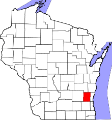
Location of Washington County in Wisconsin
This is a list of the National Register of Historic Places listings in Washington County, Wisconsin. It is intended to provide a comprehensive listing of entries in the National Register of Historic Places that are located in Washington County, Wisconsin. The locations of National Register properties for which the latitude and longitude coordinates are included below may be seen in a map.[1]
There are 26 properties and districts listed on the National Register in the county.
- This National Park Service list is complete through NPS recent listings posted November 25, 2016.[2]
Current listings
| [3] | Name on the Register[4] | Image | Date listed[5] | Location | City or town | Description |
|---|---|---|---|---|---|---|
| 1 | Amity Leather Products Company Factory | 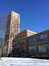 |
(#02000778) |
723-735 S. Main St. 43°24′53″N 88°10′49″W / 43.414722°N 88.180278°W |
West Bend | Billfold factory, built in 1925 and expanded in 1929, 1933 & 1959. The style is "textile mill industrial loft," designed by Lockwood, Greene & Co. with ample windows and a 6-story Art Deco tower. Made billfolds until 1996. Now apartments.[6][7] |
| 2 | Barton Historic District | Upload image | (#92000109) |
Roughly bounded by Harrison and Jefferson Sts., Barton Ave., Salisbury Rd., Monroe St. and the Milwaukee R. 43°26′30″N 88°10′55″W / 43.441667°N 88.181944°W |
West Bend | Now engulfed by West Bend, the modest former village of Barton retains survivors from its early frontier days.[8] Includes the 1850 gabled-ell Hays-Raif house,[9] the 1865 Barton Roller Mill,[10] the 1865 Frazer General Store,[11] the 1865 Greek Revival Frazer House,[12] the 1900 Gothic Revival St Mary's church,[13] the 1915 Barton Bank,[14] the 1921 Ustruck bungalow,[15] and the 1928 French Revival Kircher house.[16] |
| 3 | Christ Evangelical Church | 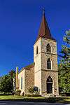 |
(#83004324) |
W188 N12808 Fond du Lac Avenue 43°15′02″N 88°09′19″W / 43.250556°N 88.155278°W |
Germantown | Gothic Revival-styled church built in 1861-62 by German immigrants from the Hunsrück Mountains of limestone blocks quarried a mile away. Now a museum.[17][18] |
| 4 | Leander F. Frisby House | 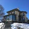 |
(#85001363) |
304 S. Main St. 43°25′15″N 88°10′52″W / 43.420833°N 88.181111°W |
West Bend | |
| 5 | Gadow's Mill | 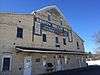 |
(#74000136) |
1784 Barton Ave. 43°26′33″N 88°10′52″W / 43.4425°N 88.181111°W |
West Bend | |
| 6 | Holy Hill | 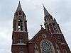 |
(#92000139) |
1525 Carmel Rd. 43°14′42″N 88°19′38″W / 43.245°N 88.327222°W |
Erin | |
| 7 | Kissel's Addition Historic District | 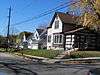 |
(#88002071) |
Rural St. and W. Root Ave. 43°18′57″N 88°22′50″W / 43.315833°N 88.380556°W |
Hartford | |
| 8 | Kissel's Wheelock Addition Historic District | 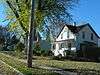 |
(#88002072) |
Roughly bounded by Church St., Wheelock and Linden Aves., Branch St., and Teddy Ave. 43°18′50″N 88°22′24″W / 43.313889°N 88.373333°W |
Hartford | |
| 9 | George A. Kissel House | 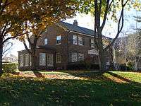 |
(#88002075) |
215 E. Sumner 43°19′03″N 88°22′33″W / 43.3175°N 88.375833°W |
Hartford | |
| 10 | Louis Kissel House | 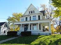 |
(#88002077) |
407 E. Sumner 43°19′03″N 88°22′26″W / 43.3175°N 88.373889°W |
Hartford | |
| 11 | Otto P. Kissel House | 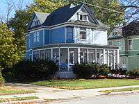 |
(#88002074) |
124 South St. 43°18′58″N 88°22′35″W / 43.316111°N 88.376389°W |
Hartford | |
| 12 | William L. Kissel House |  |
(#88002073) |
67 South St. 43°18′59″N 88°22′37″W / 43.316389°N 88.376944°W |
Hartford | |
| 13 | Lizard Mound State Park | Upload image | (#70000038) |
NE of West Bend 43°27′48″N 88°08′21″W / 43.463333°N 88.139167°W |
West Bend | |
| 14 | Messer-Mayer Mill | 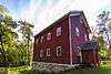 |
(#07000500) |
4399 Pleasant Hill Rd. 43°15′57″N 88°15′23″W / 43.265833°N 88.256389°W |
Richfield | |
| 15 | Ritger Wagonmaking and Blacksmith Shop |  |
(#82000717) |
4928 WI 175 43°22′15″N 88°20′02″W / 43.370833°N 88.333889°W |
Hartford | |
| 16 | St. Agnes Convent and School |  |
(#10000879) |
1386 Fond du Lac St. 43°26′16″N 88°11′06″W / 43.437778°N 88.185°W |
West Bend | |
| 17 | St. Augustine Catholic Church and Cemetery | _September_2013_02.jpg) |
(#90000638) |
Co. Hwy. Y 3 mi (4.8 km). S of jct. of Co. Hwy. Y and SR 33 43°23′03″N 88°02′28″W / 43.384167°N 88.041111°W |
Trenton | |
| 18 | St. John of God Roman Catholic Church, Convent, and School | 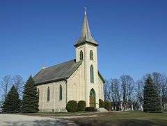 |
(#79000117) |
E of Kewaskum at 1488 Highland Dr. 43°30′48″N 88°06′35″W / 43.513333°N 88.109722°W |
Kewaskum (Boltonville) | |
| 19 | St. Peter's Church |  |
(#83003430) |
1010 Newark Dr. 43°27′17″N 88°05′11″W / 43.454722°N 88.086389°W |
West Bend | |
| 20 | Saxonia House | 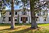 |
(#06000068) |
421 WI H 43°29′58″N 88°03′23″W / 43.499444°N 88.056389°W |
Farmington | |
| 21 | Jacob Schunk Farmhouse | 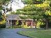 |
(#83004325) |
Donges Bay Rd. 43°12′24″N 88°06′08″W / 43.206667°N 88.102222°W |
Germantown | |
| 22 | Schwartz Ballroom |  |
(#98000564) |
150 Jefferson Ave. 43°18′37″N 88°22′37″W / 43.310278°N 88.376944°W |
Hartford | |
| 23 | Washington County "Island" Effigy Mound District |  |
(#96000417) |
Address Restricted |
West Bend | Included in the group are the mounds in Lizard Mound County Park |
| 24 | Washington County Courthouse and Jail | 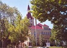 |
(#82000718) |
320 S. 5th Ave. 43°25′12″N 88°10′58″W / 43.42°N 88.182778°W |
West Bend | |
| 25 | West Bend Chicago and North Western Depot | 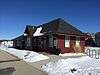 |
(#08000789) |
Veterans Ave. at Willow La. 43°25′28″N 88°10′52″W / 43.424478°N 88.181114°W |
West Bend | |
| 26 | West Bend Post Office | 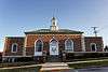 |
(#00001254) |
607 Elm St. 43°25′28″N 88°11′01″W / 43.424444°N 88.183611°W |
West Bend |
See also
| Wikimedia Commons has media related to National Register of Historic Places in Washington County, Wisconsin. |
- List of National Historic Landmarks in Wisconsin
- National Register of Historic Places listings in Wisconsin
References
- ↑ The latitude and longitude information provided is primarily from the National Register Information System, and has been found to be fairly accurate for about 99% of listings. For 1%, the location info may be way off. We seek to correct the coordinate information wherever it is found to be erroneous. Please leave a note in the Discussion page for this article if you believe any specific location is incorrect.
- ↑ "National Register of Historic Places: Weekly List Actions". National Park Service, United States Department of the Interior. Retrieved on November 25, 2016.
- ↑ Numbers represent an ordering by significant words. Various colorings, defined here, differentiate National Historic Landmarks and historic districts from other NRHP buildings, structures, sites or objects.
- ↑ National Park Service (2008-04-24). "National Register Information System". National Register of Historic Places. National Park Service.
- ↑ The eight-digit number below each date is the number assigned to each location in the National Register Information System database, which can be viewed by clicking the number.
- ↑ "Amity Leather Products Company Factory". Wisconsin Historical Society. Retrieved 2016-11-14.
- ↑ Miller, Elizabeth L. (2001-09-06). "Amity Leather Products Company Factory" (PDF). NRHP Inventory-Nomination Form. National Park Service. Retrieved 2016-11-14.
- ↑ Miller, Elizabeth L. (2001-09-06). "Barton Historic District" (PDF). NRHP Inventory-Nomination Form. National Park Service. Retrieved 2016-12-03.
- ↑ "Adams, Raif House". Wisconsin Historical Society. Retrieved 2016-12-03.
- ↑ "Gadow's Mill (Barton Roller Mills)". Wisconsin Historical Society. Retrieved 2016-12-03.
- ↑ "Otten House; Frazer General Store". Wisconsin Historical Society. Retrieved 2016-12-03.
- ↑ "Otten House; Frazer House". Wisconsin Historical Society. Retrieved 2016-12-03.
- ↑ "St. Mary's Immaculate Conception Catholic Church". Wisconsin Historical Society. Retrieved 2016-12-03.
- ↑ "Barton Bank". Wisconsin Historical Society. Retrieved 2016-12-03.
- ↑ "Ustruck". Wisconsin Historical Society. Retrieved 2016-12-03.
- ↑ "Kircher". Wisconsin Historical Society. Retrieved 2016-12-03.
- ↑ "Christ Evangelical Church". Wisconsin Historical Society. Retrieved 2016-11-14.
- ↑ Garfield, Leonard T. (1983-04-15). "Christ Evangelical Church" (PDF). NRHP Inventory-Nomination Form. National Park Service. Retrieved 2016-11-14.
| Topics | |
|---|---|
| Lists by states |
|
| Lists by insular areas | |
| Lists by associated states | |
| Other areas | |
| |
Municipalities and communities of Washington County, Wisconsin, United States | ||
|---|---|---|
| Cities | | |
| Villages | ||
| Towns | ||
| CDP | ||
| Unincorporated communities |
| |
| Footnotes | ‡This populated place also has portions in an adjacent county or counties | |
This article is issued from Wikipedia - version of the 12/4/2016. The text is available under the Creative Commons Attribution/Share Alike but additional terms may apply for the media files.