Hartford, Wisconsin
| Hartford, Wisconsin | |
|---|---|
| City | |
|
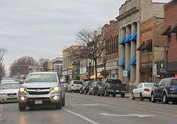
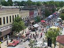
downtown Hartford on WIS 83 | |
 Location of Hartford, Wisconsin, Wisconsin | |
| Coordinates: 43°19′6″N 88°22′44″W / 43.31833°N 88.37889°WCoordinates: 43°19′6″N 88°22′44″W / 43.31833°N 88.37889°W | |
| Country | United States |
| State | Wisconsin |
| Counties | Washington, Dodge |
| Area[1] | |
| • Total | 8.02 sq mi (20.77 km2) |
| • Land | 7.94 sq mi (20.56 km2) |
| • Water | 0.08 sq mi (0.21 km2) |
| Elevation[2] | 981 ft (299 m) |
| Population (2010)[3] | |
| • Total | 14,223 |
| • Estimate (2012[4]) | 14,243 |
| • Density | 1,791.3/sq mi (691.6/km2) |
| Time zone | Central (CST) (UTC-6) |
| • Summer (DST) | CDT (UTC-5) |
| Area code(s) | 262 |
| FIPS code | 55-33000[5] |
| GNIS feature ID | 1566104[2] |
| Website |
www |
Hartford is a city in Washington and Dodge counties in the U.S. state of Wisconsin. As of the 2010 census, the city had a population of 14,223. All of this population resided in the Washington County portion of the city.
History
John Thiel and Nicolas Simon first surveyed the area that would become Hartford in 1843. James and Charles Rossman accompanied Nicolas Simon back to Hartford in 1844, and soon bought 40 acres around the rapids of the Rubicon River.[6] After constructing a dam across rapids in the river, the Rossmans built a sawmill that harnessed the power of the water to make lumber for the growth of the area. Rails were laid in 1855 that linked Chicago, Milwaukee, La Crosse and Minneapolis until the early 1900s.[7]
The town was named after Hartford, Connecticut. Hartford was a New England settlement. The original founders of Hartford consisted entirely of settlers from New England, most of whom were from Connecticut and Vermont, though some came from rural Massachusetts, New Hampshire and the region of downeast Maine. They were descended from the English Puritans who settled New England in the 1600s and were part of a wave of New England farmers who headed west into what was then the wilds of the Northwest Territory during the early 1800s. Most of them arrived as a result of the completion of the Erie Canal and the end of the Black Hawk War. When they arrived in what is now Hartford there was nothing but dense virgin forest and wild prairie. They laid out farms, constructed roads, erected government buildings and established post routes.
Values
The settlers of Hartford brought with them many of their Yankee New England values, such as a passion for education, establishing many schools as well as staunch support for abolitionism. They were mostly members of the Congregationalist Church though some were Episcopalian. Due to the second Great Awakening some of them had converted to Methodism and some had some had become Baptists before moving to what is now Hartford. Hartford, like much of Wisconsin, would be culturally very continuous with early New England culture for most of its early history.[8] The first church in Hartford was the First Congregational Church, constructed by Yankee New England migrants. The Church was built in 1847.[9][10] German and Irish immigrants began arriving after 1842, though initially in small numbers. In the late 1870s the number of German immigrants increased. [11][12]
Historic landmarks
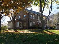
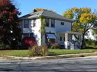
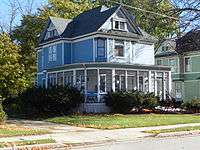
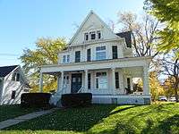
Several buildings are listed on the National Register of Historic Places and among them are some of the Kissel houses as well as houses they built for others.
The Hartford post office contains an oil on canvas mural, Autumn Wisconsin Landscape, painted in 1940 by Ethel Spears. It was produced for the Section of Painting and Sculpture (later the Section of Fine Arts) of the Treasury Department as part of the WPA Depression-era employment projects.[13]
Geography
According to the United States Census Bureau, the city has a total area of 8.02 square miles (20.77 km2), of which, 7.94 square miles (20.56 km2) is land and 0.08 square miles (0.21 km2) is water.[1]
Hartford is located within the Kettle Moraine, a large moraine formed when the Green Bay and Lake Michigan Lobes collided. These glacial movements created varied land formations such as kettles, lakes, hills, and kames that distinguish the region.[6]
Tornado of 2006
The city was the site of an F1 tornado on June 18, 2006, which caused minor damage to homes in the area, and major damage on the city's south side. Lincoln Elementary School and the Silver Bell Motel both suffered roof and structural damage.[14]
Transportation
Hartford Municipal Airport serves the city and surrounding communities.
Demographics
| Historical population | |||
|---|---|---|---|
| Census | Pop. | %± | |
| 1880 | 1,343 | — | |
| 1890 | 1,296 | −3.5% | |
| 1900 | 1,632 | 25.9% | |
| 1910 | 2,982 | 82.7% | |
| 1920 | 4,515 | 51.4% | |
| 1930 | 3,754 | −16.9% | |
| 1940 | 3,910 | 4.2% | |
| 1950 | 2,549 | −34.8% | |
| 1960 | 5,627 | 120.8% | |
| 1970 | 6,499 | 15.5% | |
| 1980 | 7,159 | 10.2% | |
| 1990 | 8,188 | 14.4% | |
| 2000 | 10,978 | 34.1% | |
| 2010 | 14,223 | 29.6% | |
| Est. 2015 | 14,355 | [15] | 0.9% |
2010 census
As of the census[3] of 2010, there were 14,223 people, 5,685 households, and 3,721 families residing in the city. The population density was 1,791.3 inhabitants per square mile (691.6/km2). There were 6,032 housing units at an average density of 759.7 per square mile (293.3/km2). The racial makeup of the city was 94.7% White, 0.9% African American, 0.5% Native American, 0.8% Asian, 1.8% from other races, and 1.2% from two or more races. Hispanic or Latino of any race were 4.8% of the population.
There were 5,685 households of which 35.1% had children under the age of 18 living with them, 51.4% were married couples living together, 9.1% had a female householder with no husband present, 5.0% had a male householder with no wife present, and 34.5% were non-families. 28.3% of all households were made up of individuals and 11.5% had someone living alone who was 65 years of age or older. The average household size was 2.47 and the average family size was 3.06.
The median age in the city was 35.6 years. 26.5% of residents were under the age of 18; 7.5% were between the ages of 18 and 24; 29.4% were from 25 to 44; 23.1% were from 45 to 64; and 13.6% were 65 years of age or older. The gender makeup of the city was 49.1% male and 50.9% female.
2000 census
As of the census[5] of 2000, there were 10,978 people, 1,397 households, and 1,152 families residing in the city. The population density was 133.6 people per square mile (51.6/km²). There were 1,438 housing units at an average density of 47.6 per square mile (18.4/km²). The racial makeup of the town was 98.88% White, 0.20% African American, 0.10% Native American, 0.37% Asian, 0.15% from other races, and 0.30% from two or more races. Hispanic or Latino of any race were 0.55% of the population.
There were 1,397 households out of which 40.6% had children under the age of 18 living with them, 74.7% were married couples living together, 4.0% had a female householder with no husband present, and 17.5% were non-families. 14.5% of all households were made up of individuals and 4.2% had someone living alone who was 65 years of age or older. The average household size was 2.88 and the average family size was 3.19.
In the city the age of the population was spread out with 28.0% under the age of 18, 6.0% from 18 to 24, 31.8% from 25 to 44, 25.8% from 45 to 64, and 8.4% who were 65 years of age or older. The median age was 38 years. For every 100 females there were 102.6 males. For every 100 females age 18 and over, there were 107.1 males.
The median income for a household in the city was estimated at $53,357 [17] and the median income for a family was $73,576. Males had a median income of $42,301 versus $29,727 for females. The per capita income for the town was $26,928. About 1.1% of families and 1.9% of the population were below the poverty line, including 4.5% of those under age 18 and 0.7% of those age 65 or over.
Government
Hartford has a mayor-council form of government. Tim Michalak is the mayor of Hartford. The Common Council is made up of nine aldermen, three elected from each of three aldermanic districts.
Economy
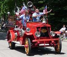
Hartford was an early car manufacturing center, home to the Kissel Motor Car Company before 1926.[18] The city was the home of a Chrysler Marine engine plant, a Libby's beet processing plant, and now many smaller industries, including the headquarters and a manufacturing site for Broan-NuTone, LLC.
Kissel's
In 1883 Ludwig “Louis” Kissel moved to Hartford and by 1890 he formed a partnership with his sons, Adolph P., Otto P., William L. and George A. that included many businesses that started with the L. Kissel & Sons Hardware store. Other enterprises ultimately included the Hartford Plow Works (1892) manufacturing and distribution of farm machinery,[19] In addition to distributing engines through Kissel Manufacturing Company for other manufacturers, the Kissel's developed their own gasoline engines, both two and four stroke, that even included a boat motor for Sears and Roebuck. Other businesses included the Hartford Electric Company, a stone quarry, and a sand pit.
In 1906, Louis, his four sons and US District Attorney H. K. Butterfield incorporated the Kissel Motor Car Company. The new auto company started full-scale production in 1907 and continued until 1930. In 1906 Otto, along with John Liver, H. K. Butterfield, and 18 other members formed the First National Bank of Hartford, with a capital of $50,000. John was elected president, H. K. Butterfield was elected vice-president and Otto Kissel was elected second vice president. Henry H. Esser was appointed cashier.Liver died in 1925 and Otto was appointed President.[20] In 1923 the Hartford Chamber of Commerce was organized with Otto Kissel, Henry Esser and John Liver as charter members. In 1936 Kissel Industries was formed, the old factory regained, and the company manufactured the Kissel outboard motor, sold as the Waterwitch from 1936 to 1944 exclusively by Sears and Roebuck.[21]
Education
The School District of Hartford provides public education to elementary students in Hartford. Lincoln and Rossman Elementary Schools each serve roughly half of the city's kindergarten through fifth grade student population. Both schools are feeders to Central Middle School, which serves all Hartford students in grades 6 through 8.
Secondary education is provided by Hartford Union High School (HUHS), which is independent of the School District of Hartford.[22] It has an enrollment of about 1700 students. The high school serves the city of Hartford, the Town of Hartford, and most of the surrounding communities including Richfield, Erin, Friess Lake, and Neosho.
Several parochial schools are in the community, including St. Kilian Roman Catholic School and Peace Lutheran.[23]
The city's library is the Jack Russell Memorial Library.
Area information
- The city has recently annexed parts of the town of Hartford and other areas, including Pike Lake. The Pike Lake Unit of the Kettle Moraine State Forest is situated on the lake.
- The city has a major industrial park on the outskirts of the city, including a Quad Graphics factory that employs many city residents.
- Hartford is home to the Schauer Arts & Activities Center, a regional arts center that stages professional touring performances, offers arts classes for all ages, and hosts social and business functions.
- Hartford is also home to Erin Hills, a public golf course selected to host the 2017 United States Open.
Notable people
- Samuel S. Barney - Justice of the U.S. Court of Claims and Congressman
- Alfred G. Becker - Wisconsin State Assemblyman
- John R. Bohan - Wisconsin State Senator
- Hopewell Coxe - Wisconsin State Assemblyman
- Steve Feak - Game Designer at Riot Games
- Edward J. Gehl - Wisconsin Supreme Court justice
- Dennis Hall - Olympic Wrestler
- Curt Hansen - Actor/Singer
- Polly Koch - Professional football player
- John A. Norman - Wisconsin State Assemblyman
- Jesse Peters - Wisconsin State Senator
- Jacob C. Place - Wisconsin State Assemblyman[24]
- Adam F. Poltl - Wisconsin State Assemblyman and Mayor of Hartford[25]
- Don Pridemore, legislator[26]
- John Reiser - Former general manager of Roush Racing NASCAR Busch Series and Craftsman Truck Series race shops
- Adam Schantz - Wisconsin State Senator
- Ronald A. Sell - Wisconsin State Assemblyman
- John Shinners - NFL player
- Jeremy Unertl - Professional football player
- Ericka Walker - Artist
- George Weissleder - Wisconsin State Senator
Images
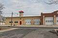 Fire & rescue building
References
- 1 2 "US Gazetteer files 2010". United States Census Bureau. Retrieved 2012-11-18.
- 1 2 "US Board on Geographic Names". United States Geological Survey. 2007-10-25. Retrieved 2008-01-31.
- 1 2 "American FactFinder". United States Census Bureau. Retrieved 2012-11-18.
- ↑ "Population Estimates". United States Census Bureau. Retrieved 2013-06-24.
- 1 2 "American FactFinder". United States Census Bureau. Retrieved 2008-01-31.
- 1 2 Hartford Centennial Committee. "Hartford, County & State History" (PDF). Retrieved 6 November 2012.
- ↑ Hartford Website Historic Page
- ↑ Stewart Hallbrook Hall, The Yankee Exodus page 141
- ↑ http://www.1stcchartfordwi.org/About_Us
- ↑ History of Washington and Ozaukee Counties page 419
- ↑ History of Washington and Ozaukee Counties, Wisconsin page 315
- ↑ The History of Wisconsin by William Fletcher Thompson State Historical Society of Wisconsin, Dec 1, 1998 ISBN 0870203037, 9780870203039
- ↑ Arnesen, Eric (2007). Encyclopedia of U.S. Labor and Working-Class History. 1. New York: Routledge. p. 1540. ISBN 9780415968263.
- ↑ JS Online: Tornado rips through Hartford
- ↑ "Annual Estimates of the Resident Population for Incorporated Places: April 1, 2010 to July 1, 2015". Retrieved July 2, 2016.
- ↑ "Census of Population and Housing". Census.gov. Retrieved June 4, 2015.
- ↑ http://www.city-data.com/city/Hartford-Wisconsin.html
- ↑ Clymer, Floyd. Treasury of Early American Automobiles, 1877-1925 (New York: Bonanza Books, 1950), p.2 & 153.
- ↑ Wendel,C H (May 20, 2004). "Encyclopedia of American Farm Implements & Antiques". Listings of Implements & Antiques. Krause Publications. p. 346. Retrieved March 29, 2015.
- ↑ First National Bank of Hartford- Retrieved 2015-03-29
- ↑ Kissel outboard- Retrieved 2015-03-29
- ↑ "Hartford Union High School District".
- ↑ http://peacehartford.org/site/default.asp?sec_id=1361&nc=1358434972275.27
- ↑ 'Wisconsin Blue Book 1880,' Biographical Sketch of Jacob C. Place, pg. 526
- ↑ 'Wisconsin Blue Book 1935,' Biographical Sketch of Adam F. Poltl, pg. 234
- ↑ 'Wisconsin Blue Book 2011-2012,' Biographical Sketch of Don Pridemore, pg. 85
External links
| Wikimedia Commons has media related to Hartford, Wisconsin. |
Municipalities and communities of Dodge County, Wisconsin, United States | ||
|---|---|---|
| Cities | 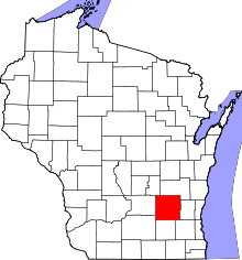 | |
| Villages | ||
| Towns | ||
| CDPs | ||
| Unincorporated communities |
| |
| Ghost towns | ||
| Footnotes | ‡This populated place also has portions in an adjacent county or counties | |
Municipalities and communities of Washington County, Wisconsin, United States | ||
|---|---|---|
| Cities | 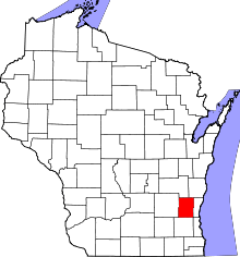 | |
| Villages | ||
| Towns | ||
| CDP | ||
| Unincorporated communities |
| |
| Footnotes | ‡This populated place also has portions in an adjacent county or counties | |