National Register of Historic Places listings in Plaquemines Parish, Louisiana
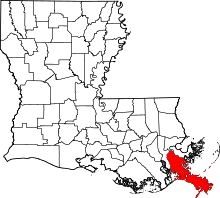
Location of Plaquemines Parish in Louisiana
This is a list of the National Register of Historic Places listings in Plaquemines Parish, Louisiana.
This is intended to be a complete list of the properties on the National Register of Historic Places in Plaquemines Parish, Louisiana, United States. The locations of National Register properties for which the latitude and longitude coordinates are included below, may be seen in a map.[1]
There are 9 properties listed on the National Register in the parish.
- This National Park Service list is complete through NPS recent listings posted December 16, 2016.[2]
Current listings
| [3] | Name on the Register | Image | Date listed[4] | Location | City or town | Description |
|---|---|---|---|---|---|---|
| 1 | Fort De La Boulaye Site | 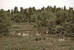 |
(#66000378) |
Eastern bank of the Mississippi River, along Louisiana Highway 39[5] 29°38′57″N 89°56′40″W / 29.6492°N 89.9444°W |
Phoenix | Fort De La Boulaye was a fort built in 1699–1700, when France took control of the mouth of the Mississippi River. |
| 2 | Fort Jackson | 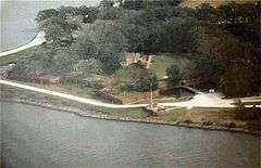 |
(#66000379) |
2.5 miles southeast of Triumph on Louisiana Highway 23 on the western bank of the Mississippi River 29°21′22″N 89°27′18″W / 29.356111°N 89.455°W |
Triumph | Fort Jackson was constructed between 1822 and 1832. In April 1862, it was the site of the Battle of Forts Jackson and St. Philip, the decisive battle for control of New Orleans during the American Civil War. A state-operated park, the fort was flooded in 2005 for several weeks following Hurricanes Katrina and Rita. |
| 3 | Fort St. Philip |  |
(#66000380) |
2.5 miles southeast of Triumph on Louisiana Highway 23 on the eastern bank of the Mississippi River 29°21′45″N 89°27′58″W / 29.3625°N 89.466111°W |
Triumph | Originally established in the 18th-century colonial period, Fort St. Philip's two important engagements were ten-day naval sieges during the War of 1812 and the American Civil War, the former an 1815 American victory against the British Royal Navy and the latter an 1862 Union Navy victory over Confederate forces guarding New Orleans. The site is privately owned and has deteriorated greatly because of river flooding, erosion, and tropical storms. |
| 4 | Harlem Plantation House | 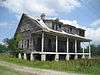 |
(#82000451) |
West of Pointe à la Hache on Louisiana Highway 39 29°37′28″N 89°54′10″W / 29.624444°N 89.902778°W |
Pointe à la Hache | |
| 5 | George Lincoln House | Upload image | (#16000301) |
30763 Parish Hwy. 11 29°44′44″N 90°01′08″W / 29.745624°N 90.019007°W |
Nairn | |
| 6 | Mary Plantation House | 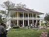 |
(#83000533) |
Louisiana Highway 39 29°48′15″N 89°59′59″W / 29.804167°N 89.999722°W |
Braithwaite | Plantation house dating to Spanish Colonial era |
| 7 | Promised Land | 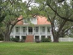 |
(#97001128) |
5907 Louisiana Highway 39 29°47′43″N 90°00′15″W / 29.795278°N 90.004167°W |
Braithwaite | Mansion of Plaquemines Parish boss Leander Perez |
| 8 | St. Patrick's Catholic Church | 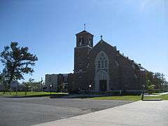 |
(#99001571) |
21997 Louisiana Highway 23 29°27′09″N 89°37′34″W / 29.4525°N 89.626111°W |
West Pointe à la Hache | |
| 9 | Woodland Plantation |  |
(#98000702) |
21997 Louisiana Highway 23 29°35′08″N 89°49′34″W / 29.585556°N 89.826111°W |
West Pointe à la Hache |
See also
| Wikimedia Commons has media related to National Register of Historic Places in Plaquemines Parish, Louisiana. |
- List of National Historic Landmarks in Louisiana
- National Register of Historic Places listings in Louisiana
References
- ↑ The latitude and longitude information provided in this table was derived originally from the National Register Information System, which has been found to be fairly accurate for about 99% of listings. For about 1% of NRIS original coordinates, experience has shown that one or both coordinates are typos or otherwise extremely far off; some corrections may have been made. A more subtle problem causes many locations to be off by up to 150 yards, depending on location in the country: most NRIS coordinates were derived from tracing out latitude and longitudes off of USGS topographical quadrant maps created under the North American Datum of 1927, which differs from the current, highly accurate WGS84 GPS system used by most on-line maps. Chicago is about right, but NRIS longitudes in Washington are higher by about 4.5 seconds, and are lower by about 2.0 seconds in Maine. Latitudes differ by about 1.0 second in Florida. Some locations in this table may have been corrected to current GPS standards.
- ↑ "National Register of Historic Places: Weekly List Actions". National Park Service, United States Department of the Interior. Retrieved on December 16, 2016.
- ↑ Numbers represent an ordering by significant words. Various colorings, defined here, differentiate National Historic Landmarks and historic districts from other NRHP buildings, structures, sites or objects.
- ↑ The eight-digit number below each date is the number assigned to each location in the National Register Information System database, which can be viewed by clicking the number.
- ↑ Location derived from its GNIS feature record; the NRIS lists the site as "Address Restricted"
| Topics | |
|---|---|
| Lists by states |
|
| Lists by insular areas | |
| Lists by associated states | |
| Other areas | |
| |
Municipalities and communities of Plaquemines Parish, Louisiana, United States | ||
|---|---|---|
| CDPs | | |
| Unincorporated communities |
| |
| Ghost towns | ||
This article is issued from Wikipedia - version of the 6/13/2016. The text is available under the Creative Commons Attribution/Share Alike but additional terms may apply for the media files.