National Register of Historic Places listings in Ketchikan Gateway Borough, Alaska
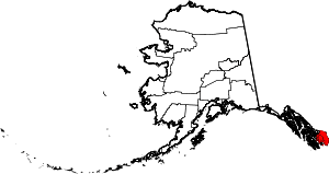
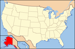
Location of the Ketchikan Gateway Borough in Alaska
This is a list of the National Register of Historic Places listings in Ketchikan Gateway Borough, Alaska.
This is intended to be a complete list of the properties and districts on the National Register of Historic Places in Ketchikan Gateway Borough, Alaska, United States. The locations of National Register properties and districts for which the latitude and longitude coordinates are included below, may be seen in a Google map.[1]
There are 19 properties and districts listed on the National Register in the borough. Another 2 properties were once listed but have been removed.
- This National Park Service list is complete through NPS recent listings posted December 16, 2016.[2]
Current listings
| [3] |
Name on the Register[4] |
Image |
Date listed[5] |
Location |
City or town |
Description |
|---|
| 1 |
Alaska Totems |
|
000000001971-06-21-0000June 21, 1971
(#71001090) |
Between Park and Deermount Avenues
55°20′35″N 131°37′55″W / 55.343056°N 131.631944°W / 55.343056; -131.631944 (Alaska Totems) |
Ketchikan |
Site of the Totem Heritage Center.
|
| 2 |
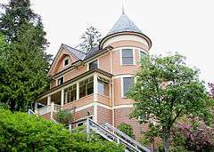
Burkhart-Dibrell House |
|
000000001982-09-08-0000September 8, 1982
(#82004902) |
500 Main Street
55°20′38″N 131°38′54″W / 55.343889°N 131.648333°W / 55.343889; -131.648333 (Burkhart-Dibrell House) |
Ketchikan |
|
| 3 |
Chief Kashakes House |
|
000000001993-04-26-0000April 26, 1993
(#93000338) |
Mile 2.5 South Tongass Highway
55°19′05″N 131°35′49″W / 55.318170°N 131.597078°W / 55.318170; -131.597078 (Chief Kashakes House) |
Saxman |
|
| 4 |
Clover Pass School |
Upload image |
000000002005-08-22-0000August 22, 2005
(#05000898) |
Potter Road off Knudson Cove Road
55°28′22″N 131°47′32″W / 55.4728°N 131.7922°W / 55.4728; -131.7922 (Clover Pass School) |
Knudson Cove |
|
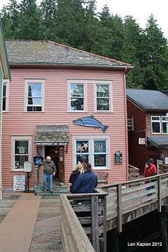
| 5 |
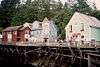
Creek Street Historic District |
|
000000002014-08-06-0000August 6, 2014
(#14000454) |
Creek St., Married Man's Trail & Totem Way
55°20′32″N 131°38′30″W / 55.3423°N 131.6417°W / 55.3423; -131.6417 (Creek Street Historic District) |
Ketchikan |
|
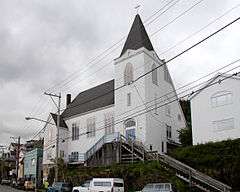
| 6 |
First Lutheran Church |
|
000000001987-05-18-0000May 18, 1987
(#87000716) |
1200 Tongass Avenue
55°20′43″N 131°39′28″W / 55.345278°N 131.657778°W / 55.345278; -131.657778 (First Lutheran Church) |
Ketchikan |
|
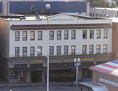
| 7 |
Gilmore Building |
|
000000001989-09-27-0000September 27, 1989
(#89001415) |
326 Front Street
55°20′32″N 131°38′52″W / 55.342361°N 131.647778°W / 55.342361; -131.647778 (Gilmore Building) |
Ketchikan |
|
| 8 |
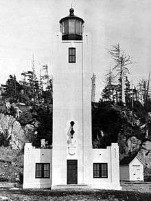
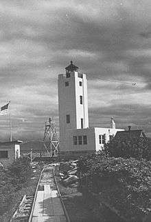
Guard Island Lighthouse |
|
000000002004-01-14-0000January 14, 2004
(#03001378) |
Guard Islands in the Clarence Strait at the northern end of Tongass Narrows, 9.6 miles northwest of Ketchikan
55°25′52″N 131°51′46″W / 55.431111°N 131.862778°W / 55.431111; -131.862778 (Guard Island Lighthouse) |
Ketchikan |
|
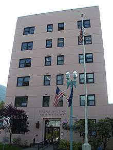
| 9 |
Ketchikan Federal Building |
|
000000002006-04-28-0000April 28, 2006
(#05000897) |
648 Mission St.
55°20′30″N 131°38′34″W / 55.341667°N 131.642778°W / 55.341667; -131.642778 (Ketchikan Federal Building) |
Ketchikan |
|
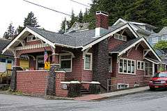
| 10 |
Ketchikan Ranger House |
|
000000001987-07-16-0000July 16, 1987
(#87000645) |
309 Gorge St.
55°20′50″N 131°39′32″W / 55.347222°N 131.658889°W / 55.347222; -131.658889 (Ketchikan Ranger House) |
Ketchikan |
|
| 11 |
Mary Island Light Station |
|
000000002005-07-08-0000July 8, 2005
(#05000645) |
Eastern shore of the northern end of Mary Island, between the Revillagigedo Channel and Felice Strait about 6-3/8 miles south of Revillagiedo
55°05′57″N 131°10′53″W / 55.099167°N 131.181389°W / 55.099167; -131.181389 (Mary Island Light Station) |
Ketchikan |
|
| 12 |
Saxman Totem Park |
|
000000001979-08-07-0000August 7, 1979
(#79003758) |
S. Tongass Highway
55°19′11″N 131°35′41″W / 55.319722°N 131.594722°W / 55.319722; -131.594722 (Saxman Totem Park) |
Saxman |
|
| 13 |
Stedman-Thomas Historic District |
|
000000001996-02-21-0000February 21, 1996
(#96000062) |
Stedman, Thomas, Inman, Brown, and Tatsudu Sts.
55°20′25″N 131°38′17″W / 55.340278°N 131.638056°W / 55.340278; -131.638056 (Stedman-Thomas Historic District) |
Ketchikan |
|
| 14 |
Storehouse No. 3 |
|
000000001977-12-07-0000December 7, 1977
(#77001575) |
Northeast of Ketchikan at Halibut Bay Estuary
55°14′08″N 130°06′05″W / 55.235556°N 130.101389°W / 55.235556; -130.101389 (Storehouse No. 3) |
Ketchikan |
|
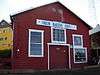
| 15 |
The Star |
|
000000001993-04-26-0000April 26, 1993
(#93000336) |
5 Creek St.
55°20′35″N 131°38′22″W / 55.343056°N 131.639444°W / 55.343056; -131.639444 (The Star) |
Ketchikan |
|
| 16 |
Totem Bight State Historic Site |
|
000000001970-10-27-0000October 27, 1970
(#70000916) |
Western side of Revillagigedo Island
55°25′23″N 131°46′17″W / 55.423056°N 131.771389°W / 55.423056; -131.771389 (Totem Bight State Historic Site) |
Ketchikan |
|
| 17 |
Tree Point Lighthouse |
|
000000002004-10-27-0000October 27, 2004
(#04001177) |
Western coast of the mainland on the eastern side of the southern entrance to the Revillagigedo Channel, about 4.25 miles north of Cape Fox
54°48′10″N 130°56′02″W / 54.802778°N 130.933889°W / 54.802778; -130.933889 (Tree Point Lighthouse) |
Ketchikan |
|
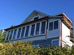
| 18 |
Walker-Broderick House |
|
000000001982-08-31-0000August 31, 1982
(#82004903) |
541 Pine St.
55°20′40″N 131°38′48″W / 55.344583°N 131.646667°W / 55.344583; -131.646667 (Walker-Broderick House) |
Ketchikan |
|
| 19 |
Ziegler House |
|
000000001985-05-30-0000May 30, 1985
(#85001161) |
623 Grant St.
55°20′40″N 131°38′43″W / 55.344444°N 131.645278°W / 55.344444; -131.645278 (Ziegler House) |
Ketchikan |
|
| [3] |
Name on the Register |
Image |
Date listed | Date removed |
Location |
City or town |
Summary |
|---|
| 1 |
Ayson Hotel |
Upload image |
000000001987-06-17-0000June 17, 1987
(#86003366) | 000000001990-06-04-0000June 4, 1990 |
301-305 Stedman St.
|
Ketchikan |
|
| 2 |
McKay Marine Ways |
Upload image |
000000001998-09-26-0000September 26, 1998
(#88001569) | 000000001990-01-18-0000January 18, 1990 |
1935 Tongass Ave.
|
Ketchikan |
|
See also
References
- ↑ The latitude and longitude information provided in this table was derived originally from the National Register Information System, which has been found to be fairly accurate for about 99% of listings. For about 1% of NRIS original coordinates, experience has shown that one or both coordinates are typos or otherwise extremely far off; some corrections may have been made. A more subtle problem causes many locations to be off by up to 150 yards, depending on location in the country: most NRIS coordinates were derived from tracing out latitude and longitudes off of USGS topographical quadrant maps created under the North American Datum of 1927, which differs from the current, highly accurate WGS84 GPS system used by most on-line maps. Chicago is about right, but NRIS longitudes in Washington are higher by about 4.5 seconds, and are lower by about 2.0 seconds in Maine. Latitudes differ by about 1.0 second in Florida. Some locations in this table may have been corrected to current GPS standards.
- ↑ "National Register of Historic Places: Weekly List Actions". National Park Service, United States Department of the Interior. Retrieved on December 16, 2016.
- 1 2 Numbers represent an ordering by significant words. Various colorings, defined here, differentiate National Historic Landmarks and historic districts from other NRHP buildings, structures, sites or objects.
- ↑ National Park Service (2008-04-24). "National Register Information System". National Register of Historic Places. National Park Service.
- ↑ The eight-digit number below each date is the number assigned to each location in the National Register Information System database, which can be viewed by clicking the number.
|
|---|
|
| Topics | |
|---|
|
| Lists by states | |
|---|
|
| Lists by insular areas | |
|---|
|
| Lists by associated states | |
|---|
|
| Other areas | |
|---|
|
-
 Portal Portal
-
 WikiProject WikiProject
|
|
|---|
|
| Boroughs | |
|
|
|
Census areas |
|
|
|
There are no sites listed on the National Register of Historic Places in Kusilvak Census Area. |


06.jpg)
.jpg)